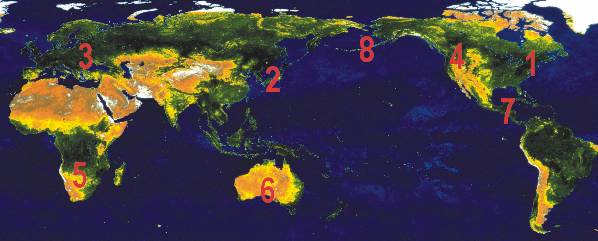
1 Whiteout
2 Oyama still smoking
3 Flooding in central Europe
4 Pacific Northwest shakes
5 Flooding and disease in southern Africa
6 Pricing disasters
7 Second strike
8 Cleveland vents

|
1 Whiteout 2 Oyama still smoking 3 Flooding in central Europe 4 Pacific Northwest shakes 5 Flooding and disease in southern Africa 6 Pricing disasters 7 Second strike 8 Cleveland vents |
|
1
Whiteout
A blizzard moved over the eastern shore of the United States and Canada
on March 6. Massachusetts took the brunt of the storm with 63.5 centimeters
(25 inches) of snow accumulating on Paxton, Mass. Ice and snow felled power
lines, cutting electricity to 80,000 people across the state. Waves broke
over seawalls, flooding coastal cities from Portland, Maine, south to Hull,
Mass.
2
Oyama
still smoking
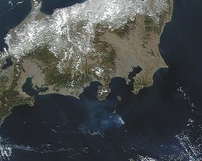 A
Feb. 22 SeaWiFS pass over Japans Miyakejima Volcano showed smoke and ash
plumes erupting from the central cone of Mount Oyama. Reports from a Feb.
5 conference in Tokyo said the volcano had been spouting 20 to 50 kilotons
of sulfur dioxide a day with no sign of decrease. The smoke trails may
reach heights of up to 2,000 meters above the crater. The volcano has been
spewing gases since it last erupted in October. The nearly 4,000 residents
that began evacuating the island last July, when Oyama first became active,
still cannot return. Journalists visiting the island on March 4 reported
seeing houses and roads still buried under mudslides.
A
Feb. 22 SeaWiFS pass over Japans Miyakejima Volcano showed smoke and ash
plumes erupting from the central cone of Mount Oyama. Reports from a Feb.
5 conference in Tokyo said the volcano had been spouting 20 to 50 kilotons
of sulfur dioxide a day with no sign of decrease. The smoke trails may
reach heights of up to 2,000 meters above the crater. The volcano has been
spewing gases since it last erupted in October. The nearly 4,000 residents
that began evacuating the island last July, when Oyama first became active,
still cannot return. Journalists visiting the island on March 4 reported
seeing houses and roads still buried under mudslides.
[Image provided by the Sea WiFS Project, NASA/Goddard Space Flight Center and ORBIMAGE.]
3
Flooding
in central Europe
Heavy rains and melting snow have inundated the region around the Carpathian
Mountains. On March 6, the Tisza River burst through its dam at the village
of Palad, near the Hungarian-Ukrainian border. Floodwaters in western Ukraine,
northeastern Hungary and parts of Transylvania, Romania, have left at least
three people dead and immersed more than 200 villages, the Associated Press
reported. Some 20,000 people were evacuated from communities along the
Tisza. More than 30,000 emergency workers and military troops fought the
flooding, using nearly 400,000 sandbags to strengthen dikes.
4
Pacific
Northwest shakes
On Feb. 28, a magnitude-6.8 earthquake struck near Seattle at 10:55
a.m. local time and lasted 45 seconds. The quake is the strongest to hit
the area in 52 years and occurred 11 kilometers northeast of the states
capital city, Olympia, very near the location of a 1949 magnitude-7.1 earthquake.
The quake originated 52 kilometers below the surface, rising from the Benioff
zone. One person has died as a result of a heart attack. Newspapers have
reported more than 200 people were injured, eight seriously. Thousands
were without power. Structural damage to the Capitol dome, falling bricks
and mudslides were of immediate concern. The estimated cost to property
was $2 billion.
5
Flooding
and disease in southern Africa
At least 20 people in Malawi have died from cholera since heavy rains
flooded parts of the east and south, news wires reported on March 5. The
swollen Zambezi River encircled some 600 families trapped on islands in
the low velds of Mozambique. Rising waters killed 10 people in Zimbabwe.
Rising waters also brought a marauding crocodile closer to people, and
the crocodile reportedly killed one person. In Mozambique, the death toll
was 62. Authorities in Zambia issued a warning that, if the rains continue,
they may open the spillway gates of the Kariba Dam to prevent it from bursting,
the Inter Press Service reported. If the dam burst, the downstream flow
would add flooding to the Zambezi Valley. Other areas inundated with continuing
downpours are Angola and the Democratic Republic of the Congo.
6
Pricing
disasters
On Feb. 28, Emergency Management Australia announced the cost of natural
and non-natural disasters across the country for the year 2000. The bill
amounted to $A1.5 billion with 42 people dead as a result of the disasters,
local papers reported. Floods in the Riverland and parts of the Barossa
in South Australia cost $32.5 million. Flooding from two cyclones that
hit Western Australia last year totaled $92 million.
7
Second
strike
A magnitude-6.1 earthquake rattled El Salvador, leaving at least 70
people dead on Feb. 14. The quake is considered an aftershock of the Jan.
13 earthquake of magnitude 7.6. The February temblor was a shallower quake
than the first quake and hit in the middle of the country rather than off
the coast, said Randall Jibson of the U.S. Geological Survey. The aftershock
shook the departments of San Vicente, La Paz, Cuscatlan, La Libertad and
San Salvador the hardest, news agencies reported. A recently reopened section
of the Pan American Highway, hit by a landslide after the Jan. 13 quake,
was buried again.
8
Cleveland
Vents
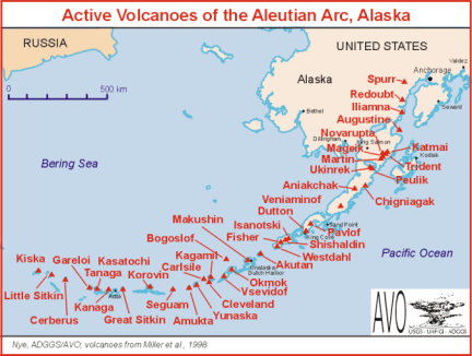 On
Feb. 19, Cleveland Volcano in the central Aleutian Islands erupted explosively
and pilots reported seeing the ash cloud top out at 35,000 feet. The plume
moved at approximately 30 knots toward Dutch Harbor, Akutan, and extended
north for at least 75 miles, said scientists at the Alaska Volcano Observatory.
Satellite images showed the main part of the ash cloud drifted mostly between
55 degrees latitude north and 171 degrees longitude west. Residents of
Nikolski, 45 miles east of the volcano, saw four hours of light ash fall.
Mount Cleveland last erupted in 1994 and has erupted 11 times since 1893.
The February eruption dumped ash on the north and east flanks of the volcano
while small debris flows may have formed on the southwest flank.
On
Feb. 19, Cleveland Volcano in the central Aleutian Islands erupted explosively
and pilots reported seeing the ash cloud top out at 35,000 feet. The plume
moved at approximately 30 knots toward Dutch Harbor, Akutan, and extended
north for at least 75 miles, said scientists at the Alaska Volcano Observatory.
Satellite images showed the main part of the ash cloud drifted mostly between
55 degrees latitude north and 171 degrees longitude west. Residents of
Nikolski, 45 miles east of the volcano, saw four hours of light ash fall.
Mount Cleveland last erupted in 1994 and has erupted 11 times since 1893.
The February eruption dumped ash on the north and east flanks of the volcano
while small debris flows may have formed on the southwest flank.
[Image at right: Active Volcanoes
of the Aleutian Arc, Alaska. Courtesy of ADGGS/AVO.]
 |
Geotimes Home | AGI Home | Information Services | Geoscience Education | Public Policy | Programs | Publications | Careers |