
The volcanoes on the westernmost Galápagos Islands are the targets of investigations that may lead to more accurate predictions of volcanic eruptions. One of the key tools in the Galápagos research is the satellite-based motion detection system known as Interferometric Synthetic Aperture Radar, or InSAR.
With InSAR, researchers say they could one day remotely monitor all active volcanoes worldwide. But so far this technology has only been looking at the vertical motion of volcanoes. Combining InSAR with the Global Positioning System (GPS) could create a 3-D view from space.
InSAR may contribute to saving lives without any risk to field crews, says volcano researcher Falk Amelung. The system detects deformation by monitoring changes in the ground-to-satellite distance over multiple satellite passes (see Geotimes, November 2000).
 In
the Oct. 15 Nature, Amelung reported unusual faulting beneath the
Galápagos volcano Sierra Negra on the island of Isabela. The faulting,
which he detected using InSAR data, explained the volcanos seeming quiescence
in a neighborhood rife with activity the land beneath Sierra Negra had
risen 2.7 meters in seven years, without an eruption.
In
the Oct. 15 Nature, Amelung reported unusual faulting beneath the
Galápagos volcano Sierra Negra on the island of Isabela. The faulting,
which he detected using InSAR data, explained the volcanos seeming quiescence
in a neighborhood rife with activity the land beneath Sierra Negra had
risen 2.7 meters in seven years, without an eruption.
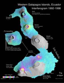
[At right: Vertical deformation at Isabela and Fernandina islands in the Galápagos archipelago, measured by InSAR. Click here for a larger version. Courtesy of Falk Amelung.]
Supported by both NASA and the European Space Agency, Amelung and his colleagues at Stanford University Sigurjón Jónsson, Howard Zebker and Paul Segall observed broad-scale ground motion using InSAR. The team determined that a series of faults beneath the volcano created a trapdoor structure in the overlying rock that temporarily relieved stress, giving flexibility and space to the rock so that more magma can squeeze in before breaching the surface. The discovery aids researchers in predicting the likelihood of eruptions at similar volcanoes elsewhere in the world and provides a new mechanism for explaining why one volcano may not have erupted though others around it have.
These kinds of studies are only possible because the European Space Agency stepped ahead at the end of the 1980s and decided to launch [the first ERS satellite], says Amelung, now of the University of Hawaii. Remote monitoring of volcano deformation is only one of the applications for the satellites that nobody even dreamt of before ERS-1 was launched, he says.
But the system measures only distance changes in line with the satellites, limiting the technology to observing the vertical motion of the volcanoes. New studies of Galápagos volcanoes are taking InSAR data to the next level, adding ground-based GPS and microgravity measurements to see horizontal motions.
With support from the National Science Foundation, one research team is in the process of installing a grid of instruments to monitor movement in a variety of directions. Dubbed G4 for Galápagos Geodetic and Gravity Grid, the instrument array uses GPS and microgravity measurements to track subcentimeter motion and magma intrusion from 51 stations on Sierra Negra and the volcanic island of Fernandina.
It is premature to state whether we have a predictive tool yet, Geist says. Still, the new techniques are receiving substantial support. Amelung is also continuing satellite-aided studies with sponsorship that includes not only the European Space Agency and NASA, but also the Canadian Space Agency and the Japanese Space Agency.
There is no doubt that GPS and InSAR will reduce hazards on a worldwide basis by aiding prediction, because of the increased coverage, high sampling rates, increased accuracy and decreased danger in data collection, Geist says.
Joshua Chamot
 |
Geotimes Home | AGI Home | Information Services | Geoscience Education | Public Policy | Programs | Publications | Careers |