Geotimes

News Notes
Impacts
Seeing Chicxulub
 Looking
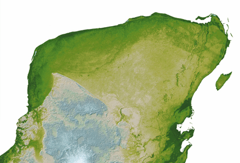
at the picture at right, you might wonder what the big deal is — it’s
just another map of the Yucatan Peninsula. But focus your attention on the upper
left corner. See that dark-green, arcing semicircle? Upon first glance, it may
not look like much, but that arc is the first actual picture of the 65-million-year-old
crater left behind after a giant impact that researchers believe killed the
dinosaurs.
Looking
at the picture at right, you might wonder what the big deal is — it’s
just another map of the Yucatan Peninsula. But focus your attention on the upper
left corner. See that dark-green, arcing semicircle? Upon first glance, it may
not look like much, but that arc is the first actual picture of the 65-million-year-old
crater left behind after a giant impact that researchers believe killed the
dinosaurs.
Part of a high-resolution mapping database of North America released in March,
this picture outlines the 180-kilometer wide Chicxulub crater using radar interferometry
from the Space Shuttle Endeavor. In the coming months, NASA will be releasing
datasets for other continents.
Image courtesy of
NASA/JPL.
“What’s neat about this picture is that the trough has
never been seen in any kind of photography or picture from space or even airplanes
before,” says Michael Kobrick, project scientist for NASA’s Shuttle
Radar Topography Mission (SRTM). “If you’re walking across it, you
probably wouldn’t even notice it.”
The highest point in the whole picture is about 300 meters. The semicircular
trough is just a few meters deep over about 5 kilometers and represents the
dissolving away of limestone along the crater’s rim. “What happened
65 million years ago is that this thing hit out in the water in the Gulf of
Mexico and blasted out a crater; but subsequently, it got covered over with
these carbonates, limestone sediments,” he says. The impact had altered
and destabilized the rocks below, causing the limestone to fracture.
“That dark green line is the rim of where the crater at Chicxulub would
be if there were really a crater there now,” Kobrick says. Just below that
arc are several little dots — sinkholes called cenotes. “That’s
an indication of how porous this limestone is and how easily it dissolves. The
cenotes are preferentially strung out along the arc of this curve,” Kobrick
says. Tourists can scuba dive in the cenotes, traveling through the area’s
vast system of underground caves and tunnels.
For the past 20 years, researchers have known about Chicxulub and, through ground
surveying and gravity measurements, have known about the trough. In 1995, Alan
Hildebrand at the University of Calgary first described Chicxulub’s topographic
features in a Nature paper. He noted a fracture system about 5 kilometers wide
with a parallel cenote ring.
Hildebrand says he is delighted to see a clear demarcation of the trough and
the cenotes in the SRTM image that mirrors his own description. “The data
and image are beautiful,” he says. “The level of detail is terrific.”
On a larger version of the map, rows of trees are visible. The map’s resolution
is almost five times better than called for in the original SRTM specifications.
When geologists studying Chicxulub requested the Yucatan data from Kobrick,
he didn’t expect to see anything. “I was really surprised to see this
nice arcing line,” Kobrick says.
SRTM is giving researchers the best topographic views ever of historically poorly
mapped areas, such as the Yucatan, Kobrick adds. “This is the first digital
topographic map of the Yucatan that’s any good at all and the first that
actually shows the surface expression of Chicxulub,” he says. “Now
if you’re giving a lecture about Chicxulub, you can actually put up a picture
on the screen and point to it and say, ‘Look, there it is.’”
Lisa M. Pinsker
