Geotimes
Feature
Life Along the Fault:
Reducing Risk in Utah
Gary E. Christenson
The importance of the earth sciences to society is rarely more apparent than
during a natural disaster. Lives are disrupted, government services are strained
and society’s safeguards are severely tested. Threats from geologic events
continue despite our modern technology and advances in understanding and awareness.
 The Federal Emergency
Management Agency (FEMA) estimates average annual earthquake losses at $4.4
billion in the United States. The U.S. Geological Survey (USGS) estimates that,
nationwide, landslides cause over $1 billion in damages and cost 25 to 50 lives
every year. The National Oceanic and Atmospheric Administration estimates average
annual flood losses at $4.5 billion with about 100 deaths.
The Federal Emergency
Management Agency (FEMA) estimates average annual earthquake losses at $4.4
billion in the United States. The U.S. Geological Survey (USGS) estimates that,
nationwide, landslides cause over $1 billion in damages and cost 25 to 50 lives
every year. The National Oceanic and Atmospheric Administration estimates average
annual flood losses at $4.5 billion with about 100 deaths.
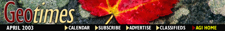
Utah Geological Survey geologists
survey a channel bend in one of the Santaquin debris flows. The geologists will
use the data to calculate discharge and velocity of the debris flow. Photos
courtesy of UGS.
One of the great contributions earth scientists and state geological surveys
can make is to help protect lives and property from geologic hazards. At the
Utah Geological Survey (UGS), our philosophy is to use earth science information
to help reduce the risks people face from natural hazards. State geological
surveys can raise awareness of hazards, advocate responsible risk reduction,
perform research to better understand hazards, and help developers and regulators
promote safe land use.
Principal hazards include earthquakes, landslides and floods. Geologic hazards
are particularly important in Utah because of their variety, frequency and coincidence
with urban areas. Utah’s populous Wasatch Front, including the state capital
Salt Lake City and contiguous Provo and Ogden metropolitan areas, sits in the
most geologically hazardous part of the state.
 A challenge for UGS
is reducing risks from geologic hazards for new development by identifying areas
where hazards may exist, and convincing local governments to adopt and enforce
ordinances that require developers to address the hazards. The challenge is
significant. First, despite the survey’s efforts for new development, risks
inherited from previous building and land-use practices remain high and losses
continue. Second, annual losses from geologic hazards will continue to increase
as development moves into less favorable areas unless risks are properly reduced.
UGS experience has shown that many forces act to impede risk reduction, including:
the perceived high cost of assessing hazards and taking steps to reduce risks;
high levels of uncertainty in hazard assessments; relative infrequency of major
hazards; and lack of earth-science expertise at the local government level,
where land-use regulation typically occurs.
A challenge for UGS
is reducing risks from geologic hazards for new development by identifying areas
where hazards may exist, and convincing local governments to adopt and enforce
ordinances that require developers to address the hazards. The challenge is
significant. First, despite the survey’s efforts for new development, risks
inherited from previous building and land-use practices remain high and losses
continue. Second, annual losses from geologic hazards will continue to increase
as development moves into less favorable areas unless risks are properly reduced.
UGS experience has shown that many forces act to impede risk reduction, including:
the perceived high cost of assessing hazards and taking steps to reduce risks;
high levels of uncertainty in hazard assessments; relative infrequency of major
hazards; and lack of earth-science expertise at the local government level,
where land-use regulation typically occurs.
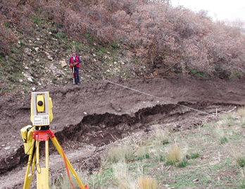
Utah Geological Survey geologists lead
a field trip for geologists and government officials to a trench across the
Wasatch fault in southern Salt Lake County.
A key tool in overcoming these obstacles is the wise use of earth science information.
Already, using such information in land-use regulation and building practice
has helped prevent potentially greater losses from natural hazards. State geological
surveys have played an active role in this prevention.
Earthquakes in a
growing region
Over 80 percent of Utah’s 2.3 million people live in the central Wasatch
Front along Utah’s most active fault, the Wasatch fault. The fault extends
the entire length of the Front at the base of the Wasatch Range along the eastern
edge of the urban area. The fault itself trends through expensive east-side
neighborhoods, and may extend beneath high-rise buildings in downtown Salt Lake
City. However, the Wasatch fault itself has not generated a major earthquake
in historical time, and the most recent one to affect the Wasatch Front was
a magnitude-6.6 earthquake in 1934 on the Hansel Valley fault north of Great
Salt Lake. In general, large earthquakes do not occur often enough in Utah to
“remind” people that they are living and building in earthquake country.
UGS, in cooperation with USGS and others, has undertaken extensive geologic
studies of faults along the Wasatch Front as potential sources of large earthquakes.
These studies involve trenching across the faults to reconstruct the timing
and size of past surface-faulting earthquakes (greater than magnitude 6.5) to
assess how active and dangerous the various faults are as sources of damaging
ground shaking. For the Wasatch fault, these studies indicate that the active
central segments generate magnitude-7.0 or greater earthquakes on average every
350 years, and that the last one was about 600 years ago in the Provo area.
Our studies have resulted in a map and database of all known Quaternary faults,
which USGS uses for preparing national seismic hazard maps that in turn provide
the basis for designing buildings, bridges and dams.
 The Wasatch Front
also has many soil and groundwater conditions that increase the severity of
an earthquake and thus the likelihood of damage. UGS has prepared 1:75,000 to
1:250,000-scale maps for estimating the potential effects of soils on earthquake
ground shaking, and worked with private-sector and university seismologists
to prepare ground-shaking maps for the Salt Lake City and Wasatch Front areas.
The Wasatch Front
also has many soil and groundwater conditions that increase the severity of
an earthquake and thus the likelihood of damage. UGS has prepared 1:75,000 to
1:250,000-scale maps for estimating the potential effects of soils on earthquake
ground shaking, and worked with private-sector and university seismologists
to prepare ground-shaking maps for the Salt Lake City and Wasatch Front areas.
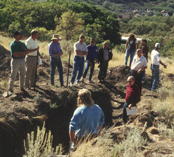
Two years after the 2001 Heather Drive
landslide in Layton, Utah — Utah Geological Survey geologists continue
to monitor movement on the main scarp at the head of the landslide.
Shallow groundwater and liquefiable soils are also common in the lower parts
of Wasatch Front basins. As the ground shakes in an earthquake, sandy soils
below the water table may liquefy and lose their ability to support structures,
causing damage due to settlement. Liquefaction is particularly dangerous when
it occurs on slopes, even very gentle slopes, causing destructive landslides
that are a major source of earthquake damage.
UGS studied large-scale, prehistoric landslides and lateral spreads induced
by liquefaction to better understand these hazards. Non-liquefaction-induced
landslides are also a major concern. Our reliance on lifelines, including highways,
railroads and utility corridors, from surrounding mountains, and the susceptibility
of these mountain slopes to earthquake-induced landslides, greatly increases
the risk. To aid in emergency response planning and estimating losses, UGS prepared
scenario maps for a magnitude-7.0 earthquake in the Salt Lake City area. The
maps identify where damage from ground shaking, faulting, liquefaction and landslides
is most likely.
Building on hillsides
Landslides, debris flows and alluvial-fan floods are common in Utah in the
foothills along the base of the Wasatch Range in response to wet climatic conditions.
In 1983 alone, landslides and floods caused by rapid melting of a record winter
snowpack accounted for hundreds of millions of dollars in damages. The disastrous
Thistle landslide blocked a main highway and railroad corridor and dammed a
river, costing more than $200 million itself. Recent landslides in 1997 and
1998 caused major damage throughout the Wasatch Front. The 2001 Heather Drive
landslide in Layton, 25 miles north of Salt Lake City, destroyed or forced removal
of six houses and cost more than $1 million.
Nearly all recent landslides occurred in areas of pre-existing landslides now
identified on geologic-hazards maps. Unfortunately, most development in these
areas predated awareness of the importance of geologic hazards, and also predated
completion of modern geologic-hazards maps. To help reverse this trend, UGS
works with communities affected by recent landslides to adopt and enforce hillside
protection ordinances that will better address geologic hazards in the future.
UGS geologists are participating on a technical review panel to advise Provo
City regarding existing and proposed new development on a large, partially active
but very slow-moving landslide. In landslide emergencies, UGS assists local
governments by mapping the landslides, assessing hazards and the likelihood
of continued movement, providing information to the public and press, and providing
advice about plans for future development. We prepared a technical analysis
of the 1998 landslides evaluating landslide types and characteristics, causative
climatic conditions, instability thresholds and the role of hillside modifications.
One goal of the analysis was to improve our ability to identify potentially
unstable slopes before people build on or near them.
Alluvial-fan surfaces provide flat, scenic, desirable mountain-front building
sites. However, alluvial fans are built by sediment-laden debris flows and floods
that wash out of the mountains. Debris flows and alluvial-fan floods from storms
following mountainside wildfires have been a particular hazard in Utah during
drought years since 1998. A large wildfire denuded hillsides above the Wasatch
Front communities of Santaquin and Spring Lake 55 miles south of Salt Lake City
in 2001. The fire destroyed the vegetation that controls runoff and protects
the soil from erosion, leaving hillsides vulnerable. A 2002 storm generated
debris flows from 10 canyons, one of which flooded a subdivision, causing major
damage to five houses and two businesses, and minor damage to 27 other houses.
UGS performed scientific investigations to understand this event and the continuing
long-term hazard, and also showed that the damages occurred in known high-risk
areas shown on existing geologic-hazards maps. We continue to work with local,
state and federal agencies to implement federal emergency risk-reduction programs
in the area and to promote the use of geologic-hazards maps in long-term risk
reduction.
Helping local governments
Utah’s State Code grants authority for regulating land use to local governments,
both cities and counties. To regulate land use with respect to geologic hazards,
local governments typically adopt ordinances that require developers to perform
studies prior to construction to identify geologic hazards and demonstrate that
risks are acceptable or will be reduced to acceptable levels. Although this
process sounds relatively straightforward, assessing geologic hazards and establishing
levels of acceptable risk tap into very complex, controversial and political
topics that many local governments are unprepared and ill-equipped to face.
UGS provides technical assistance to cities and counties to help promote wise
land use and encourage uniform levels of acceptable risk among jurisdictions.
Our efforts are directed at outreach to local government planning staffs, planning
commissions and elected officials. We encourage them to adopt ordinances, and
we assist them in implementing those ordinances. UGS provides models of effective
ordinances and assistance in adapting them to local geologic conditions. We
prepare generalized, 1:24,000-scale geologic-hazards maps showing areas where
hazards may exist in a community. Local governments adopt these maps in ordinances
to show where site-specific studies are required before developers can build.
Local governments also use the maps to develop master plans. Developers and
their consultants use the maps to understand local-government requirements.
 In the late 1980s,
UGS acquired USGS funding so that the major Wasatch Front counties could employ
geologists for three years to prepare geologic-hazards maps and work with city
and county planners to use those maps. The work of these geologists, along with
continued mapping of adjoining areas by UGS, has culminated in maps of geologic
hazards (1:24,000-scale) available to everyone living in the Wasatch Front.
Site-specific studies required by city and county planners using these maps
typically recommend risk-reduction measures such as fault setbacks, slope modifications,
and flood or debris-flow containment or diversion where needed. Most major Wasatch
Front communities follow this procedure. Although the level of enforcement is
variable, we believe these measures have significantly reduced long-term risk.
In the late 1980s,
UGS acquired USGS funding so that the major Wasatch Front counties could employ
geologists for three years to prepare geologic-hazards maps and work with city
and county planners to use those maps. The work of these geologists, along with
continued mapping of adjoining areas by UGS, has culminated in maps of geologic
hazards (1:24,000-scale) available to everyone living in the Wasatch Front.
Site-specific studies required by city and county planners using these maps
typically recommend risk-reduction measures such as fault setbacks, slope modifications,
and flood or debris-flow containment or diversion where needed. Most major Wasatch
Front communities follow this procedure. Although the level of enforcement is
variable, we believe these measures have significantly reduced long-term risk.
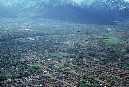
The scarp of the active trace of
the Wasatch fault — the linear shadow shown by arrows in the center —
stretches along the east side of the Salt Lake City metropolitan area.
A critical element of enforcing geologic-hazards ordinances is to review the
reports on potential hazards that developers submit to local governments. Salt
Lake County is the state’s only local government still employing a geologist
to perform these reviews. Outside of Salt Lake County, UGS geologists review
hazard reports for local governments as requested. These reviews evaluate both
the technical aspects of the hazard assessment and the recommended hazard-reduction
measures. Whereas hazard assessments are chiefly technical applications of the
earth sciences, recommendations for risk-reduction measures are based on a concept
of acceptable risk that may vary between a developer and a local government.
Therefore, UGS works with local governments in reviewing reports and helping
them to understand the uncertainties and risks involved so that the interests
of the city, future homeowners and city taxpayers are protected.
UGS also provides advice to local governments in responding to geologic disasters
such as earthquakes and landslides. Local government responders at the scene
of a disaster typically need to know: what additional areas may be affected
by a hazard such as a landslide or debris flow; whether a hazard remains after
the initial event; and whether warning and evacuation procedures are necessary.
UGS immediately responds to natural disasters to work directly with emergency
responders as needed.
In any disaster, information is the key. UGS has developed a detailed response
plan to coordinate geologic investigations and establish an information clearinghouse
following a major earthquake. The purpose of the clearinghouse is to share information
among emergency responders and scientists, and provide information to the media
and general public, in real-time.
Information is also the key to long-term risk reduction. State geological surveys
not only study and map geologic hazards and disseminate information, but actively
reach out and work with government partners, developers, residents and other
constituents to promote the beneficial use of earth-science information for
reducing risks.
Christenson
is manager of the Geologic Hazards Program at the Utah Geological Survey, and
has 27 years of experience working in engineering geology and geologic hazards
throughout the western United States. E-mail him at: garychristenson@utah.gov.
