Geotimes

Feature
A Circuitous Path:
Protecting Groundwater in Wisconsin
Kenneth R. Bradbury
Open most basic groundwater textbooks and you’ll find hydrogeology discussed
in terms of porous media, with aquifers composed of well-sorted sand, and groundwater
moving through pores between sand grains. In the dolomite terrain of northeastern
Wisconsin, however, the story is much different. Over much of Wisconsin’s
Door Peninsula, fractured dolomite is exposed at or near the land surface. Rain
or snow falling on this landscape enters the groundwater system through an interconnected
network of vertical and horizontal bedrock fractures. Once in the aquifer, the
water flows laterally, through horizontal fractures, until it discharges to
local lakes, springs or streams or is captured by water-supply wells.
 In such systems,
rapid groundwater movement and minimal contaminant attenuation are common, and
so the land-use practices in the areas where the water originates — often
called the capture zones or contributing areas — highly influence the quality
of groundwater produced by local wells.
In such systems,
rapid groundwater movement and minimal contaminant attenuation are common, and
so the land-use practices in the areas where the water originates — often
called the capture zones or contributing areas — highly influence the quality
of groundwater produced by local wells.
Determining these capture zones and understanding how groundwater moves from
recharge to local wells are critical to protecting groundwater in fractured-rock
terranes.
The Wisconsin Geological and Natural History Survey (WGNHS) has carried out
a series of field-based, hydrogeologic research investigations with the goal
of improving our understanding of fluid movement in fractured carbonate rocks
throughout Wisconsin. The other aim of this research is to find the best methods
for protecting groundwater and making sure contaminants are not carried to the
wells that supply drinking water. Undertaking wellhead-protection studies in
fractured-rock settings is a challenging endeavor, yet it is in these very vulnerable
settings that wellhead-protection programs are most essential.
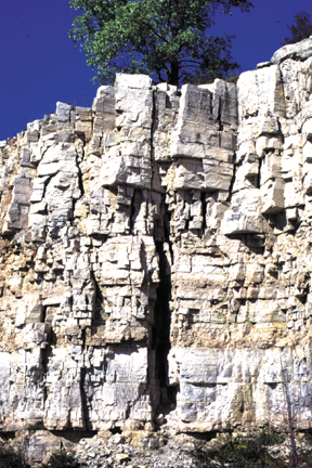
The vertical and
horizontal fractures in this Silurian dolomite in Door County are typical of
the fractures that underlie the county and affect the groundwater. Photos courtesy
Wisconsin Geological and Natural History Survey, University of Wisconsin-Extension.
The focus of our work is the Silurian dolomite aquifer of Door County, in northeastern
Wisconsin. A rocky peninsula between Lake Michigan and Green Bay, Door County
has rugged shorelines, mild climate, abundant natural resources and a small-town
feel that together have made it one of the most popular tourist destinations
in the midwestern United States.
All residents of the county depend on groundwater, but groundwater quality problems
have plagued the county for many years. Bacteria and nitrate exceed U.S. Environmental
Protection Agency and Wisconsin drinking water standards in about 30 percent
of the private wells in the county, and private well owners often report turbid
or muddy water in their wells during certain times of the year. Other groundwater
contaminants include agricultural chemicals, pesticide residues from cherry
and apple orchards, and petroleum and other non-aqueous phase liquids such as
gasoline and solvents.
Much of Door County’s charm, and its groundwater problems, are directly
related to its unique geology — a combination of Paleozoic bedrock and
Pleistocene modifications. Silurian-age dolomites form the backbone of the peninsula
and dip gently eastward into the Michigan Basin. In the Late Pleistocene, continental
glaciers covered the area, and, when they retreated, left behind a fascinating
landscape.
On the western side of the county the Silurian escarpment forms high cliffs
along the Green Bay shoreline; only a few miles to the east the land meets Lake
Michigan with sandy beaches and diverse wetlands. In between, in the uplands
of the county, the glaciers removed most of the soil, so that in most places
the bedrock is less than two meters below the surface and in many places it
is exposed at the land surface. The dolomite contains both near-horizontal and
vertical fractures. These fractures are extensive, and the vertical fractures
are easily visible from the air, particularly under alfalfa fields in dry weather.
The combination of thin soils and fractured rock makes groundwater in the county
extremely vulnerable to contamination.
Over the past 20 years, WGNHS has carried out a number of scientific studies
of the hydrogeology of Door County at the request of, and with substantial funding
from, local, state and even national regulatory agencies. Each of these studies
has involved the collection and analysis of new field data and has included
extensive cooperation with local landowners, citizens’ groups and decision
makers. Each project builds on previous work and has led to a broader understanding
of fractured-rock hydrogeology that WGNHS scientists have shared in national
and international venues. For example, Maureen Muldoon, now at the University
of Wisconsin-Oshkosh, carried out detailed groundwater monitoring and tracer
experiments in an active dolomite quarry, producing some of the most detailed
data on dolomite hydrogeology ever collected.
A fast trip to the Bay
The City of Sturgeon Bay (population 9,100) lies midway up the Door Peninsula
and is the county seat as well as an important industrial and recreational center.
Sturgeon Bay’s water supply comes entirely from municipal wells drawing
water from the fractured dolomite aquifer. In 1998, the Sturgeon Bay Water Utility,
with support and funding from the Wisconsin Department of Natural Resources,
requested that the WGNHS provide assistance in delineating the capture zones
for its municipal wells in support of a wellhead-protection plan. The motivation
for this project was twofold: to assist the City of Sturgeon Bay and the county,
and to gain a better understanding of how groundwater moves and of techniques
for delineating the capture zone. This understanding could be applied to other
fractured carbonate aquifers in the state.
Since the turn of the century, the city has installed 12 municipal wells within
the city limits; nine of these wells have shown signs of bacterial contamination,
and seven of the wells have been shut down and abandoned. Currently the city
operates five wells. Water from three of these wells is disinfected on site.
Only two wells have remained free of bacterial contamination.
 We used our
observations and field measurements from the Sturgeon Bay area to create a model
showing how rapidly groundwater moves near the city. The existing wellhead protection
guidelines are based on a five-year travel time from infiltration at the land
surface to capture by the municipal wells. But we found that travel times to
municipal wells are so rapid — less than two years — and distances
traveled are so large — up to 10 kilometers — that the traditional
criteria for wellhead protection are meaningless.
We used our
observations and field measurements from the Sturgeon Bay area to create a model
showing how rapidly groundwater moves near the city. The existing wellhead protection
guidelines are based on a five-year travel time from infiltration at the land
surface to capture by the municipal wells. But we found that travel times to
municipal wells are so rapid — less than two years — and distances
traveled are so large — up to 10 kilometers — that the traditional
criteria for wellhead protection are meaningless.
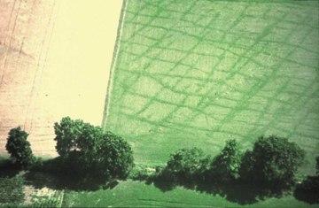
Vertical fractures visible in an alfalfa
field, central Door County, reflect fractures below in the carbonate rocks.
The alfalfa grows greener and more vigorously above sediment-filled fractures.
The predicted short travel times of the flow system are consistent with our
conceptual model and with numerical modeling results. Additional geochemical
and isotopic data collected for this study are consistent with the results of
those models. These isotopes can act as effective natural groundwater tracers
and should be used routinely in groundwater studies in fractured carbonate rocks.
Armed with the technical understanding that municipal well water is coming from
several kilometers away and from outside the city limits, the city, water utility
and county officials are working together to develop a wellhead-protection plan
that will identify and perhaps reduce potential contaminant sources at the land
surface in the contributing areas for the city wells.
How we tracked the groundwater
The Sturgeon Bay work spanned several years and involved numerous investigators,
graduate students and local officials.
Field investigations: Extensive field
investigations supported the modeling and analyses for this project and had
four main objectives: 1) Characterize the hydraulic its temporal variability.
We collected water-level measurements during dry and wet seasons and analyzed
the historic record of water-level fluctuations at long-term monitoring wells
in the area. 2) Evaluation of bulk aquifer properties. We conducted a large-scale
pumping test using existing municipal wells and also analyzed the results of
specific-capacity tests on several hundred domestic wells throughout the study
area. 3) Detailed analyses of dolomite hydrostratigraphy. The hydrostratigraphic
analyses were a key part of this project and included rock core examination,
downhole geophysical logging, straddle-packer experiments and stratigraphic
correlation of high-permeability features. 4) Collection of geochemical and
isotopic data for model verification.
Hydrostratigraphy and conceptual model:
Determining the location and continuity of horizontal flow zones in the dolomite
aquifer was essential to simulate groundwater flow accurately in the study area.
The basis for the conceptual model of the aquifer was the work of Maureen Muldoon,
Toni Simo of the University of Wisconsin at Madison and others, who identified
14 horizontal, high-permeability zones within the dolomite aquifer in the Sturgeon
Bay area. All are parallel to bedding and are most highly developed at lithologic
contacts.
These zones, predominantly bedding-plane fractures that have been widened by
solution, are critical to groundwater flow because they provide pathways for
rapid horizontal groundwater movement. Five of the zones are continuous across
the study area and can be correlated on both sides of Sturgeon Bay. The flow
zones range in thickness from 0.3 to 11 meters and represent boundaries of contrasting
lithologies, layers with high primary porosity or lithologies that contain numerous
bedding-plane partings at the boundaries of depositional cycles.
Five laterally continuous flow zones are in the vicinity of Sturgeon Bay. We
defined the intervals of aquifer between the flow zones as “non-flow”
zones. Although some groundwater flow occurs in the non-flow zones, the amount
is relatively small in comparison to that in the flow zones.
Numerical modeling: Simulating groundwater
flow near Sturgeon Bay required a 3-D transient groundwater flow model with
spatial and temporal variability of recharge rates, simulation of near-horizontal
flow zones, and representation of flow boundaries. A transient model most accurately
reflects aquifer behavior because of the seasonal water level fluctuation seen
in wells.
Working with Todd Rayne of Hamilton College in New York, we constructed a porous
media porous media groundwater flow model, using the USGS’ MODFLOW modeling
code model. We simulated the flow zones as thin, continuous, highly permeable
layers. The intervals between the flow zones were modeled as thicker layers
with lower horizontal and vertical hydraulic conductivities. The 11 bedrock
model layers dip approximately 1 degree to the southeast. The top layer, representing
glacial deposits and lake sediment, truncates the bedrock layers unconformably
and has variable thickness. The thickness of each remaining bedrock layer is
uniform throughout the model domain, but thickness varies between layers. Reverse
particle tracking through the transient groundwater flow field delineated the
land surface area from which water is likely to reach each well.
Model results and verification: The
modeling indicated that wells on the north side of the city have contributing
areas extending nearly 10 kilometers to the northeast; contributing areas for
the wells on the south side of the city extend nearly 7 kilometers to the southwest.
Groundwater travel times from the water table to the municipal wells vary with
depth in the well, but in all cases are quite short. The average travel time
from the water table to the wells is 150 days. The minimum and maximum simulated
travel times are, respectively, 14 days and 730 days.
Several of the particles had paths originating in surface water, indicating
that some municipal wells may be inducing the flow of surface water from the
bay into the aquifer. All particles reached the water table or the bay within
the two-year simulation time. The near-horizontal flow zones clearly control
groundwater movement to the municipal wells. Groundwater movement is largely
vertical from the water table to the first major flow zone. Upon entering a
flow zone, groundwater movement is mostly horizontal.
To verify the conceptual and numerical models of the Sturgeon Bay system, we
collected temperature, electrical conductivity and oxygen isotope data from
groundwater and precipitation samples in one of the contributing areas. Natural
precipitation varies seasonally in oxygen isotope ratio and temperature, and
the electrical conductivity of recharge water also varies throughout the year.
These variations compose a signal that should remain imprinted on groundwater
in the study area during its relatively rapid movement from recharge to pumping
wells. Rapid and significant changes in water temperature and electrical conductivity
occurred in two monitoring wells equipped with continuous recorders. These changes
show the discrete nature of recharge events in the study area and demonstrate
how rapidly recharge moves into the groundwater flow system. Stable isotopic
ratios of oxygen and hydrogen varied significantly with time and location during
the sampling period.
Results of particle-tracking simulations agree with the observed behavior of
the aquifer. Simulated breakthrough curves for low recharge periods show an
average travel time of about 40 days, compared to eight days for particles released
from the same location at a time of high recharge. This flow rate compares extremely
favorably with the nine-day change in oxygen-18 ratio observed at a city well
following a significant recharge event. The rapid transport occurred because
of substantially higher hydraulic gradients in the aquifer during times of high
recharge.
It doesn’t end with a report
At the conclusion of funding for the Sturgeon Bay project, we prepared a report
for the funding agencies that summarized our findings. But our commitment to
the project did not end there. As a unit of the University of Wisconsin-Extension,
WGNHS scientists follow the “Wisconsin Idea”: communicating research
to the people of the state. The Sturgeon Bay project was no exception.
During and after the project, we have frequently interacted with local officials
and citizens; our contributions range from making phone calls and visiting county
boards. We prepare copy for articles in the local newspaper and participated
in an outdoor environmental fair. We provided advice as the county soil and
water conservation staff worked in partnership with the water utility to develop
a wellhead-protection plan for the area. Beyond the local scene, we have presented
information from the Sturgeon Bay project in professional journal articles and
at national and international meetings. We have incorporated this information
into professional short courses on fractured-rock hydrogeology.
Most important, our scientific investigations have made subsequent studies of
fractured rock in other parts of Wisconsin better. Each project builds on previous
work. Working with a variety of students, colleagues and cooperators, WGNHS
scientists have carried out nationally recognized research while continuing
to stay in touch with local issues and providing advice and assistance to local
citizens and officials.
Bradbury
has been a research hydrogeologist and professor with the Wisconsin Geological
and Natural History Survey, University of Wisconsin-Extension since 1982. His
research interests include the hydrogeology of fractured rocks, wellhead protection
and regional groundwater modeling. E-mail him at: krbradbu@facstaff.wisc.edu.
