 More than a century
has passed since the last catastrophic volcanic eruption in Central America. In
1902, the Santa María Volcano in Guatemala erupted, devastating more than
150 square kilometers and causing 2,000 to 3,000 direct fatalities. Although subsequent
regional volcanic activity has been relatively mild, more powerful eruptions certainly
will occur in the future. Volcanoes located in densely populated areas, however,
need not have powerful eruptions to produce disastrous results. General population
growth and migration from the countryside to urban centers, many of which in Central
America are in close proximity to volcanoes, create ever-increasing exposure of
people to volcano hazards.
More than a century
has passed since the last catastrophic volcanic eruption in Central America. In
1902, the Santa María Volcano in Guatemala erupted, devastating more than
150 square kilometers and causing 2,000 to 3,000 direct fatalities. Although subsequent
regional volcanic activity has been relatively mild, more powerful eruptions certainly
will occur in the future. Volcanoes located in densely populated areas, however,
need not have powerful eruptions to produce disastrous results. General population
growth and migration from the countryside to urban centers, many of which in Central
America are in close proximity to volcanoes, create ever-increasing exposure of
people to volcano hazards. A new scale
As with most other hazardous geophysical events, such as earthquakes, the consequences
of a volcanic eruption depend on its magnitude and what is at risk. And as with
other hazards, we can assign a magnitude of effects to the risks.
The Volcano Explosivity Index, or VEI, is a measure of eruption magnitude, similar
to the Richter Scale for earthquakes. Created by Chris Newhall and Steve Self
in 1982, the VEI is a scale from 0 to 8 of increasing explosivity based on a
number of factors, including volume of tephra, column height and eruption duration.
Each number represents an approximate factor of 10 increase in explosivity;
population is irrelevant.
Unlike for many natural hazards, however, we can anticipate the locations of
volcanic eruptions as well as the populations at risk. Because eruptions also
have precursory unrest and generally can be forecasted, effective mitigation
of volcanic hazards is often possible by temporarily evacuating the population
at risk. In proximal areas, the time between eruption onset and the resulting
hazard — for example, pyroclastic flows, ballistic projectiles and lahars
(large mudflows) — is often measured in seconds to minutes.
VPI is an effort to quantify the risk based on population in order to facilitate
mitigation. It is an outgrowth of the Volcano Disaster Assistance Program (VDAP)
in connection with recent work in Central America. VDAP is jointly funded by
the U.S. Geological Survey (USGS) and the U.S. Office of Foreign Disaster Assistance.
Specifically, the VPI was developed to objectively determine populations at
risk living around the 80 active volcanoes in Central America. We are now extending
the VPI calculations to other volcanic regions, including the United States,
to produce a global summary.
Calculating VPI
Two key tools used in developing the VPI are the LandScan population database,
created at the Oak Ridge National Laboratory, and volcano coordinates from the
Smithsonian’s Global Volcanism Program, both available online. LandScan
is a gridded global population database with a resolution of approximately 1
kilometer. Best available census data are distributed within census tracts based
on land cover, proximity to roads, slope and nighttime lights.
In our pilot study of Central America, we reviewed the Smithsonian volcano coordinates
to ensure that calculations of the VPI from some of the more complex volcanic
systems used the most appropriate vent or vents. To create the VPI, the volcano
coordinate data are circumscribed by 5- and 10-kilometer radii (VPI5 and VPI10
respectively). The resulting circular areas intersecting with the LandScan grid
yield the estimated included population.
We chose 5- and 10-kilometer radii for the VPI to address risk from small- to
moderate-sized eruptions that occur most frequently and thus the eruptions that
emergency responders and civil authorities will most likely have to face. A
review of the global magnitude-frequency relation for volcanic eruptions by
Tom Simkin and Lee Siebert in 1994 shows that VEI 2 eruptions occur somewhere
on Earth every few weeks on average. VEI 3 eruptions occur several times a year;
VEI 4 eruptions occur once or twice a year; VEI 5 eruptions occur about once
per decade; and VEI 6 eruptions about once or twice per century.
The VPI is specifically designed to be most useful in the VEI 2 to VEI 4 range.
Even small VEI 2 eruptions may produce hazardous phenomena, such as ballistic
projectiles or tephra fall, that warrant evacuation of populations within 5
kilometers; most VEI 5 eruptions and some larger VEI 4 eruptions will usually
involve evacuation within or beyond 10 kilometers.
The precise outcomes of ongoing volcanic unrest can rarely be forecasted with
any certainty. Not all episodes of volcanic unrest culminate in an eruption,
and, for those that do, scientists are generally not able to anticipate changes
in the eruption course, such as a sudden escalation, that would pose a significant
threat to nearby populations. Thus, volcanologists can only give an imprecise
range of the magnitude and style of eruption to expect, typically based on knowledge
of a volcano’s prehistoric and historical eruptive history. This problem
is particularly acute if eruptions have been infrequent or entirely prehistoric.
Our use of simple circles with 5- and 10-kilometer radii is supported by a couple
of independent lines of evidence. In 2002, Newhall and Rick Hoblitt published
in the Bulletin of Volcanology a global compilation of eruption effects with
distance and assigned exceedance probabilities of severe hazards for VEI 3,
4 and 5 eruptions reaching various distances. For small- to moderate-sized eruptions,
severe hazards will reach only 5 to10 kilometers from a vent.
We also reviewed recent evacuations made in response to small to moderate volcanic
activity in Central America to ascertain what distances from the volcano people
were typically evacuated. For 15 separate small to moderate eruptions (maximum
VEI 4) at six different volcanoes, the distances evacuated were always 4 to
10 kilometers away, generally involving areas downwind from the volcano. Thus,
given the uncertainty of style and magnitude of a potential eruption, people
within 5 kilometers of any threatening volcano almost certainly will be evacuated
until the eruption settles into a well-characterized pattern or ceases altogether.
People within 5 to 10 kilometers of a threatening volcano may be evacuated,
depending on local conditions. For small- to moderate-sized eruptions, VPI5
and VPI10 numbers can provide authorities with a reliable estimate of the minimum
numbers of people that may need to be evacuated and cared for, should the volcanic
unrest culminate in an eruption.
The ranks
Central America has 30 historically active volcanoes; for this region, recorded
history dates back to the early 1500s. Calculation of the VPI10 in the region
indicates that approximately 2.7 million people in Central America have potentially
significant exposure to volcano hazards.
|
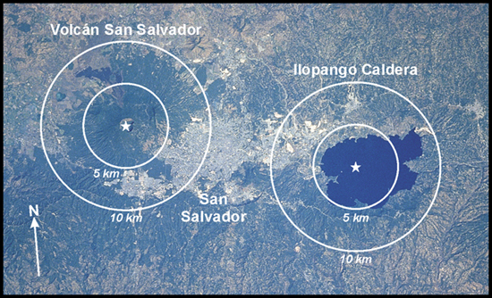
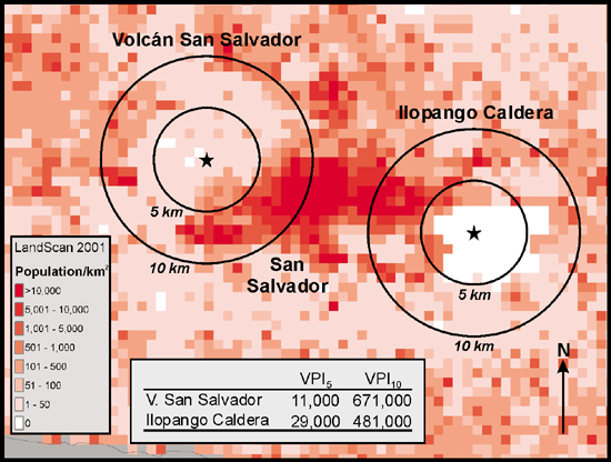
| The city of San Salvador is sandwiched between two volcanoes, Volcán San Salvador and Ilopango Caldera, as shown in the Space Shuttle photo above. The 5- and 10-kilometer-radius circles outline the areas used in calculating Volcano Population Index (VPI) for each volcano; stars indicate the site of the most recent eruptions at each volcano. Looking at LandScan populations around the two volcanoes (below) and calculating a VPI, volcanologists can help communities better prepare for evacuation. Each LandScan cell is approximately 1 square kilometer. Top: Base photo courtesy of Earth Sciences and Image Analysis Laboratory, NASA Johnson Space Center. Bottom: Courtesy of John Ewert. |
|
Compared to some other volcanic regions of the world, Central America stands
out in terms of the sheer numbers of people living in close proximity to historically
active volcanoes. Our preliminary analysis of other volcanic regions suggests
that only Indonesia has more people at risk. But, Indonesia has many more historically
active volcanoes — about 2.5 times the number in Central America. In Central
America, however, urban areas are closer to active volcanoes. Use of the VPI
allows scientists to identify those volcanoes where even relatively small eruptions
may result in a disproportionately huge disaster.
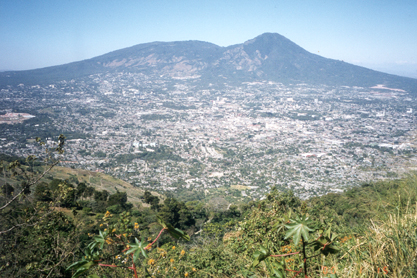
San Salvador area, El Salvador. Not surprisingly, El Salvador has the
largest number of people living near active volcanoes; it has one of the highest
population densities in the western hemisphere. The capital city, San Salvador,
is a large urban area with well-known, historically active volcanoes anchoring
the eastern and western ends of the city.
On the eastern end of the city is Ilopango, a silicic caldera that produced
a powerful eruption (VEI 6) in approximately A.D. 429 that devastated much of
what is now modern El Salvador and had a profound impact on the Mayan civilization.
Ilopango was again active in 1879-1880, when a mostly nonexplosive eruption
extruded lava domes into the caldera lake. On the western end of the city sits
Volcán San Salvador, a complex andesitic system with many potentially
active vents oriented southeast to northwest within about 10 kilometers of its
main vent, Boqueron. The most recent eruption of Volcán San Salvador
occurred in 1917.
Of the nearly 1.4 million Salvadorans within 10 kilometers of a historically
active volcano, 80 percent live within 10 kilometers of Volcán San Salvador
and Ilopango. Thus a moderately explosive eruption from either of these volcanoes
would have a large impact on the city of San Salvador and, because it is the
capital and commercial center of El Salvador, on the entire country. Both volcanoes
are seismically monitored by the Servicio Nacional de Estudios Territoriales,
and Volcán San Salvador has been the subject of several hazards studies.
A hazards assessment of Ilopango is in preparation.
Quetzaltenango area, Guatemala. VPI calculations indicate that in Central
America, Guatemala ranks second in the number of people within 10 kilometers
of a historically active volcano. Surprisingly, more than half of these people
are threatened by a single, little-known volcano, Cerro Quemado, in the highlands
of Guatemala.
Cerro Quemado does not have a classic volcanic cone shape like its more famous
neighbor Santa María; it lies behind the volcanic front and is a small
complex of coalescing domes and lava flows with a total volume of about 2 cubic
kilometers. The most recent eruption occurred in 1818, when it produced a large
trachyandesite lava flow. Approximately 700 years prior to the 1818 eruption,
Cerro Quemado produced a small debris avalanche (a smaller version of the event
that occurred in 1980 on Mount St. Helens) that was followed by a lateral blast
and pyroclastic flows, which devastated at least 40 square kilometers to the
northwest. But what makes Cerro Quemado truly exceptional is its proximity to
Quetzaltenango, the second largest city in Guatemala.
More people live within 5 kilometers of Cerro Quemado than any other historically
active volcano in Central America. Although the volcano does not appear to have
been frequently active, it is a young system that tends to erupt explosively.
At the present time, there is no seismic monitoring of the volcano and the nearest
seismic station is approximately 10 kilometers away, near Santiaguito, the currently
active vent on the south side of Santa María Volcano. In cooperation
with VDAP, the Instituto Nacional de Sismología Vulcanología Meteorología
e Hidrología and the Coordinadora Nacional para la Reducción de
Desastres will be installing a seismic station to monitor Cerro Quemado this
year.
Limits of the VPI
Although the VPI does a good job of estimating the number of people who are
potentially at risk from fast moving, severe volcanic hazards, it gives only
a minimum estimate. Even the VPI10 will underestimate the number of persons
at risk from many VEI 4 eruptions and all larger eruptions, as well as eruptions
from snow- and ice-capped volcanoes, which can produce lahars that may travel
100 kilometers or more.
In regions such as South America, North America and Japan, where primary lahar
hazards can be severe, lahar-hazard zones extending beyond 10 kilometers obviously
need to be considered. In such cases or when a more accurate evaluation of population
at risk at an individual volcano is needed, the LandScan database can be used
in combination with a hazard-zonation map to produce a suite of population risk
estimates based on a variety of possible scenarios. The 1-kilometer grid size
of the current release of LandScan is the principal limiting factor in making
precise estimates of population at risk.
Nevertheless, the VPI is useful for estimating minimum numbers of people that
may need to be cared for during an eruption. Moreover, as a communication tool,
the VPI can effectively convey the magnitude of risk in terms that are easily
understood by nonscientists (for example, emergency managers, affected populace
and journalists). We will continue to use the LandScan database and to refine
the VPI in our efforts to reduce risks from volcano hazards.
Dull, R.A., Southon, J.R., and Sheets, P.D., 2001, Volcanism, ecology, and culture: a reassessment of the volcán Ilopango TBJ eruption in the souther Maya realm: Latin American Antiquity, v. 12, no. 1, p.25-44.
Newhall, C.G. and Hoblitt, R.P., 2002, Constructing event trees for volcanic crises: Bulletin of Volcanology, v. 64, p. 3-20.
Newhall, C.G. and Self, S., 1982, The volcanic explosivity index (VEI): an estimate of explosive magnitude for historical volcanism: Journal of Geophysical Research, v. 87, p. 1231-1238.
Simkin, T., and Siebert, L., 1994, Volcanoes of the World: Geoscience Press, Tucson, 349 p.
 |
Geotimes Home | AGI Home | Information Services | Geoscience Education | Public Policy | Programs | Publications | Careers |