
Landslides kill thousands of people around the world each year and wreak costly
property damage, especially in heavily populated mountainous regions such as
the Alps. A new service funded by the European Space Agency might be able to
reduce some of those losses by using satellites to predict where and when landslides
might occur.
The Service for Landslide Monitoring project, or SLAM, began operating in February
over Italy and Switzerland with the goal of identifying and monitoring slope
movement. Using images from the European Remote Sensing Satellite (ERS), researchers
have been able to create detailed landslide hazard maps that pinpoint unstable
slopes and make it easier to predict potential slope failures.
This is the first time synthetic aperture radar (SAR) and interferometry have
been used together to forecast landslides, says Gerald Wieczorek, a civil engineer
with the U.S. Geological Survey’s Landslide Hazards Program. SAR obtains
images of an area from different positions along the satellite’s path,
emulating a much larger antenna. Interferometry is the process of combining
radar images taken at different times.
“The interferometric techniques are able to detect precursory deformations
which don’t produce any superficial evidences in the terrain, such as terraces,
tensional cracks or damage to buildings,” says Nicola Casagli of Italy’s
National Group for the Prevention of Hydrogeological Hazards, a research network
working with Italy’s Civil Protection Department and a SLAM user.
Several factors can trigger landslides, including heavy rain, earthquakes, volcanic
activity, changes in groundwater flow and human-induced slope disturbances.
However, the early detection of landslides that can move at speeds ranging from
millimeters per year to kilometers per hour has proved challenging.
In the past, researchers have used monitoring devices to detect the minuscule
ground shifts that occur on a slope prior to a landslide. Unlike SAR interferometry,
however, the devices cannot cover large regions simultaneously and are usually
limited to slopes already known to be unstable.
“There are some very sensitive ground-based monitoring techniques that,
if the appropriate instruments had been installed, would detect slight preceding
motion,” Wieczorek says. “But the instruments would have to be there
and in the right place.”
SLAM provides users with two unique methods of observation. The first, called
differential interferometry, provides maps of displacement over time. “By
comparing, pixel by pixel, the phase values of two SAR images acquired in the
same area at different times, it is possible to obtain information about the
ground deformations that occurred within the observed area, with centimetric
accuracy,” Casagli says.
The second method, called the permanent scatterers technique, provides accuracy
to the millimeter, Casagli says. Instead of using two single SAR images, researchers
use a series of at least 25 images and look for fixed points, such as walls
or large boulders, which occur in every image. They can then compare these permanent
scatterers with various points in the landscape, allowing them to identify even
minute changes.
One of the first test cases for SLAM will be coverage of the Arno River Basin,
a 9,000-square-kilometer area with a population of 2.5 million, where more than
3,000 landslides have occurred, mostly due to erosion, rain and earthquakes.
Ideally, for hazard management purposes, researchers would be able to predict
the location, time, type, size, velocity and run-out distance of a landslide.
In order to determine as many of these variables as possible, SLAM researchers
will compare new SAR imagery with historical imagery recorded since ERS launched
a decade ago, and combine that information with geological models of slope failures.
“Although several assumptions are made in order to simplify the complex
behavior of a mass movement, such models can provide a useful tool, especially
for emergencies management,” Casagli says.
Sara Pratt
Geotimes contributing writer
 The town of
Paso Robles lies in the southern end of the Salinas Valley, on California’s
central coast. The town owes its existence to natural hot springs in the region,
which people visited for their “curative powers.” Even the town’s
main street, Spring Street, is named for these features. Now, a new hot spring
has come to town, opened by the magnitude-6.5 earthquake that killed two people
and leveled part of the town’s historic center last December.
The town of
Paso Robles lies in the southern end of the Salinas Valley, on California’s
central coast. The town owes its existence to natural hot springs in the region,
which people visited for their “curative powers.” Even the town’s
main street, Spring Street, is named for these features. Now, a new hot spring
has come to town, opened by the magnitude-6.5 earthquake that killed two people
and leveled part of the town’s historic center last December.
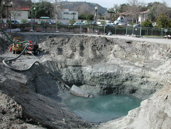
The San Simeon earthquake last December
opened a new hot spring in Paso Robles, Calif., but digging has not helped clarify
the spring’s origin. Photo by Robert Anderson, California Seismic Safety
Commission.
Bubbling since the Dec. 22 earthquake, the sulfur spring has spewed thousands
of gallons a day of hot water laced with boron into the Paso Robles City Hall
parking lot. Despite excavating a pit 150 feet wide by 150 feet deep, the city
has yet to locate the source of the spring. Such features may be the most difficult
earthquake effect to characterize, says Lew Rosenberg, county geologist for
San Luis Obispo County. “It’s easy to see a surface crack or fault,
but where the water comes from is more mysterious and elusive,” he says.
One of the questions geologists must answer, Rosenberg says, is how this new
spring is connected to the town’s other springs and the fault system. Over
the past few months, the water pressure has dropped in springs built into a
resort hotel across the street. U.S. Geological Survey mapping shows that both
Spring Street and a string of springs are aligned along the Rinconada fault,
on which the town sits. It is unclear, Rosenberg says, if the new spring is
part of the same seepage system.
The city has hired a consultant to use thermal imaging in order to find hot
springs and the thermal connections between them. Although the geothermal activity
is nowhere near as great as California’s Geysers field farther north (which
is connected to volcanic activity), the water is coming from depths that circulate
within the fault zone, several hundred feet deep.
The county also is looking for a solution to disposing of the chemical-laced
waters discharged from the unexpected spring: For now, the stream of warm, high-boron
sulfuric water goes directly to the Salinas River, but both the high temperature
and boron content could affect the river’s fish.
Rosenberg and his co-workers have documented a variety of other phenomena connected
to the recent earthquake, from liquefaction effects near Pismo Beach to large
earthquake-induced landslides. “Geologically, it’s been really neat,”
he says, and continued work on this central portion of California’s fault
systems is important, in order to “help us connect what we know about northern
and southern California geology.”
Naomi Lubick
Back to top
 The magnitude-7.7
earthquake that struck Bhuj, India, in 2001, released a pressurized slurry of
water and soil, creating small sand volcanoes and cracks. Water continued to
flow, sometimes for days afterward, all as a result of liquefaction. But the
earthquake also triggered delayed explosions of dry liquefaction craters —
a surprising phenomenon, says Martitia Tuttle, a Maine-based consulting geologist
who also has studied liquefaction after large earthquakes in San Francisco and
Quebec.
The magnitude-7.7
earthquake that struck Bhuj, India, in 2001, released a pressurized slurry of
water and soil, creating small sand volcanoes and cracks. Water continued to
flow, sometimes for days afterward, all as a result of liquefaction. But the
earthquake also triggered delayed explosions of dry liquefaction craters —
a surprising phenomenon, says Martitia Tuttle, a Maine-based consulting geologist
who also has studied liquefaction after large earthquakes in San Francisco and
Quebec.
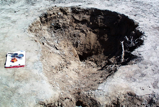
A dry liquefaction crater in Bhuj, India,
that appeared after a large 2001 earthquake. Photo by Martitia Tuttle.
“It’s not unusual to see a delayed surface manifestation of underground
liquefaction,” Tuttle says. But the dry craters are harder to explain.
Paul Rydelek of the Center for Earthquake Research and Information (CERI) at
the University of Memphis, and Tuttle published their description of the dry
blowouts and other ejecta in the Jan.8 Nature. Although the team remains
uncertain about the exact dynamics of how dry craters might occur, they hypothesized
that gas trapped in the clay and sand layers — pressurized and then jostled
by an earthquake — might lead to explosive ejection of the gas and material.
“It’s bizarre, and I have to say that when I first saw it I didn’t
believe it,” says Eugene Schweig, a U.S. Geological Survey geologist located
at CERI and a co-worker of Tuttle’s. But Schweig says the observations
clearly show that dry craters can occur, and the hypothetical cause — collapse
of a gas-filled cavity — is appealing. The question remains as to how the
gas gets there.
Naomi Lubick
Back to top
 |
Geotimes Home | AGI Home | Information Services | Geoscience Education | Public Policy | Programs | Publications | Careers |