
 No
one can miss, even from a satellite image of Earth, the green strip of land
at the northeastern tip of Africa. The swath starts in the south, following
the great African rift that connects the Nile in Egypt with tributaries in Ethiopia
and equatorial Africa. Swollen in summer with rain that gathered a few months
earlier in its tropical tributaries, the Nile overflows from the confines of
its channel to form a narrow floodplain that runs north for a thousand kilometers
in Egypt before it enters the Delta to finally deliver its water into the Mediterranean
Sea.
No
one can miss, even from a satellite image of Earth, the green strip of land
at the northeastern tip of Africa. The swath starts in the south, following
the great African rift that connects the Nile in Egypt with tributaries in Ethiopia
and equatorial Africa. Swollen in summer with rain that gathered a few months
earlier in its tropical tributaries, the Nile overflows from the confines of
its channel to form a narrow floodplain that runs north for a thousand kilometers
in Egypt before it enters the Delta to finally deliver its water into the Mediterranean
Sea.
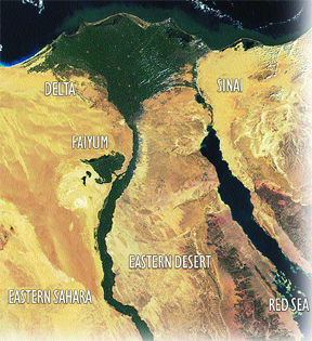
Summer floods in the Nile River create
a narrow strip of fertile land at the northern end of the African Rift in Egypt.
Annual, decadal and centennial variations in flood discharge made agriculture
possible in the region, thus forming the backbone of Egyptian civilization.
A bowl-shaped valley called the Faiyum Depression received water from the Nile
via an inlet traversing the desert hills that separated it from the river valley.
This depression was the site of a major water-management and land-reclamation
project in ancient Egypt around 1900 B.C. Climate changes throughout time have
shaped water-management decisions in the region. Courtesy of Fekri Hassan.
Eleven thousand years ago, the inhabitants of the Nile Valley pursued hunting,
gathering and fishing. By 5850 B.C., goats and sheep from the Levantine cradle
were brought to the deserts surrounding the Nile Valley, and by 4795 B.C., communities
of farmers, who were cultivating wheat and barley and were herding sheep, goats
and cattle, began to emerge in the Nile Delta. Egypt was on its way to becoming
one of the major agricultural centers of the ancient world.
By necessity, the agricultural cycle depended on the summer floods, and the
year was subdivided into three seasons: the season of inundation, the season
of drought when the Nile is at its lowest level and the in-between season. In
July, the main flood discharge would begin with a crest of reddish-brown muddy
water from the highlands of Ethiopia. By the middle of August, the inundation
would reach its peak. By the end of October, the inundation waned, and water
began to subside, with the Nile sinking to its lowest level by May. Then from
May to September, the rise of flood water could reach as much as 7 meters.
Today, the flow of the Nile in Egypt is regulated by the Aswan High Dam. But
in the past, this predictable annual rhythm was superimposed on more capricious
variations in Nile flood discharge over decades, centuries and millennia. Farmers
could hardly anticipate the long-term vagaries of Nile floods, and as a result,
Egyptian civilizations suffered at times from catastrophically high or low Nile
flood discharge.
Geoarchaeological investigations are now revealing the complex dynamics of interactions
between the Nile and Egyptian civilizations. The results reveal close connections
between climate change and variations in Nile floods. They also show the need
in current and future projects to consider the volatile and sudden changes in
global climate, which at times, seriously threatened the viability of Egyptian
civilizations.
Collapse of the Old Kingdom
Within the span of two millennia following the adoption of an agricultural mode
of life in Egypt, communities began to coalesce in progressively larger social
groups. By 3300 B.C., the whole country was unified in a single state ruled
by kings who launched huge pyramid-building programs that were indicative of
a strongly centralized government and of general prosperity. Pyramid building
during the Old Kingdom coincided with a period of bountiful Nile floods. Rather
unexpectedly, however, by 2185 B.C., the centralized government disintegrated
and the country plunged into an age of chaos, disorder and violent internal
conflicts.
The sudden and dramatic collapse of the Old Kingdom government marked the onset
of the “First Intermediate Period,” also once called the “First
Dark Age.” The cause of the civilization’s demise remained a mystery
until geological investigations revealed that Egypt had suffered from a series
of catastrophically low Nile floods due to abrupt climate change. As crops failed,
there was a food shortage, aggravated by speculators who hoarded grain, which
led to starvation, disease, death, civic unrest and political turnover.
The first geologic clue to this collapse came from a study of a lake in a bowl-shaped
valley called the Faiyum Depression, situated 90 kilometers south of Cairo.
In prehistoric times, the depression was filled with water, forming an extensive
lake. Beach gravel between 20 and 34 meters above sea level marks paleo-shorelines
of a huge lake far bigger than the current lake, with a shoreline at 45 meters
below sea level. The lake was fed by Nile water flowing into the depression
through an inlet from a branch of the Nile Valley.
During the Old Kingdom, the level of the lake oscillated between 18 and 20 meters
above sea level. The lake covered most of the extensive depression. A quay to
transport blocks of basalt from quarries in northern Faiyum marks the high level
of the Old Kingdom lake. Surprisingly, my own examination of lake bottom sediments
revealed that deposits from the Old Kingdom lake were missing — suggesting
that the lake had dried up and that the Old Kingdom deposits were winnowed away.
A team of scientists, led by Jean-Daniel Stanley of the Smithsonian Institution,
has now substantiated this explanation, by analyzing sediments obtained from
drilling the subsurface sediments of the Delta. The geologists noticed a distinctly
thin layer of reddish-brown silt dating between 2250 to 2050 B.C., coincident
with the time of the collapse of the Old Kingdom. The layer indicated that the
delta floodplain dried up for a long period of time, allowing reddish-brown
iron oxides to accumulate at the surface. The scientists also detected a significant
change in the ratio of strontium isotopes, which they interpret as evidence
for a decline of rainfall in Ethiopia, the main source of Nile floods.
There is also compelling evidence from the ongoing drilling program in Memphis,
Egypt, by David Jeffreys at University College London, of dry conditions, represented
by encroaching desert sand that began to engulf the Old Kingdom capital at Memphis
during the First Intermediate Period. This dryness apparently caused a shift
of the capital to the south and east. The desert sand extended as a massive
sheet of windblown sand for at least half a kilometer from the edge of the escarpment.
It remained a prominent feature of the landscape until medieval times.
A similar situation was also observed farther north at Abu Roash. And the intensification
of sandstorms and the encroachment of sand on Old Kingdom settlements are also
evident outside the Delta. Moreover, investigations at ‘Ayn Asil in Dakhla
Oasis reveal a progressive sanding-up of the site by the end of the Old Kingdom.
More than 4 meters of windblown sand were deposited before the site was finally
abandoned.
The tie between low rainfall at the Nile’s source and Faiyum Lake’s
receding levels and the Delta dryness is revealed by dry climatic conditions
in Ethiopia and equatorial Africa during the period from 2200 to 2100 B.C. For
example, a conspicuous episode of aridity spans from about 2150 to 2100 B.C.
in the high-resolution pollen sequences from Burundi, provided by Raymonde Bonnefille
of the French National Centre for Scientific Research (CNRS) and his collaborators.
This dry episode is also apparent in Rwanda, the highlands of Uganda, Lake Victoria
and Ethiopia. In a study of diatoms from Lake Abhe in Ethiopia, French paleoclimatologist
Françoise Gasse, also of CNRS, detected a very pronounced drop in lake
level at the time of the First Intermediate Period.
The drought extended also to the African Sahel. An investigation of the Lake
Kajemarum Oasis and dune deposits in northeastern Nigeria revealed that a marked
drying of climate and deterioration of vegetation commenced at 2150 B.C. This
change led to the formation of the present-day semi-arid landscape, due to a
pronounced shift in atmospheric circulation with significant degradation of
terrestrial and aquatic ecosystems. In addition, investigations at Lake Bosumtwi
in Ghana reveal that the level of the lake fell in 2150 B.C., in response to
arid conditions.
The 2200 B.C. climatic event was most likely due to severe cold spells more
characteristic of an ice age than of the warmer conditions that prevailed before
the event. Ice cores from Greenland show a weak circulation over the Atlantic
at that time, which is associated with a transition from birch and grassland
vegetation to arctic conditions in Iceland in 2150 B.C. This spell of severe
cold caused a shift to a drier climate in southeastern Europe.
The impact of the cold phase was also felt farther afield in areas affected
by the Intertropical Convergence Zone. For example, dry conditions were observed
in a record from Lake Sumxi in western Tibet in 2200 B.C. In addition, a definite
transition to a variable late Holocene climate occurred in 2100 B.C., as revealed
by marine sediments off the southern coast of Chile. This global event was also
felt in the eastern Mediterranean, as indicated by a high-resolution study of
deposits at Soreq Cave that revealed a massive reduction of 20 to 30 percent
in rainfall at the time.
A hydraulic civilization
 The global
climatic event that ultimately caused the collapse of the Old Kingdom was short-lived.
The country was devastated for a quarter of a century before it began to take
the first steps toward recovery. These initial steps were a prelude to major
waterworks that transformed Egypt into a hydraulic civilization.
The global
climatic event that ultimately caused the collapse of the Old Kingdom was short-lived.
The country was devastated for a quarter of a century before it began to take
the first steps toward recovery. These initial steps were a prelude to major
waterworks that transformed Egypt into a hydraulic civilization.
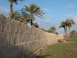
Remnants of a dam originally constructed by the Ptolemies around 250 B.C. represent
an effort to reclaim land and protect low-lying land from flooding. Courtesy
of Fekri Hassan.
In response to falling flood levels, the chiefs of a district adjacent to the
Faiyum Depression began to dig canals to supply parched fields with water. As
their strength grew, they made allies and enemies in other parts of Egypt. In
due time, they were overtaken by rulers from Thebes (modern Luxor) in the far
south. The new kings, who styled themselves as great pharaohs, continued the
waterworks in the Faiyum at a scale hitherto unknown in ancient Egypt.
According to legend, not content with simple canal digging, the new rulers decided
to build a dam at Lahun, excavate a reservoir and regulate the flow of water
into the Faiyum Depression. In years of drought, the reservoir would supply
the area downstream with water. The project also entailed restricting water
flow into the Faiyum Depression to reclaim a vast area of cultivable land.
As a signal of their commitment to the Faiyum hydraulic project, the pharaohs
of the Middle Kingdom moved their capital just north of the Faiyum Depression,
midway to the Old Kingdom capital at Memphis. To celebrate their achievements,
they also, for the first time, constructed two pyramids at El-Lahun and Hawara
near the beginning and end of the water inlet into the Faiyum, and they erected
the first colossal obelisk.
The hydraulic project likely began with King Senusert II (1897 to 1879 B.C.)
and continued until the reign of King Amenemhat III (1844 to 1797 B.C.). The
project would have included, first of all, the dredging of a branch of the Nile
now called Bahr Yusuf to allow water to flow again into the Faiyum Depression.
During the period of droughts, Bahr Yusuf dried up and must have been filled
with windblown sand. Instead of allowing water to refill the depression, water
flow was regulated to maintain the lake level at 14 meters above sea level in
order to reclaim a vast area for agriculture. Occasionally water was allowed
to rise to higher levels to accommodate high Nile floods, as indicated by looking
at the location of the Sobek temple and the colossal statues of the kings, which
were 18 meters above sea level until 1800 B.C., versus the location of Middle
Kingdom lake sediments in northern Faiyum.
The Greek historian and writer Herodotus visited the Faiyum Depression during
the 5th century B.C. Most of the depression was filled with water, and he was
unable to get close to the statues that once stood at the edge of the lake.
From a distance, he thought that the statues were two pyramids in the middle
of the lake.
Today, only the pedestals of the king’s statues remain standing, with stone
blocks from the statues scattered on the ground. Looking for any clues of ancient
lake levels, I discovered beach sediments lodged below one of the collapsed
blocks. Therefore, at a time after 1800 B.C. and before the collapse of the
blocks, the level of the lake rose well above 18 meters above sea level to drown
the area once occupied by the Middle Kingdom installations. This was a sudden
turn of events, as a few hundred years before, the Nile levels were devastatingly
low. Efforts to cope with low Nile floods were countermanded by an unexpected
increase in flood discharge. The dam was breached and the Faiyum Depression
became once more uninhabitable.
Recently, a combined team from University College London, Cairo University,
the Egyptian National Center for Remote Sensing, and the National Center for
the Documentation of Cultural and Natural Heritage began to extract new cores
from the bottom of the lake and the areas in front and behind the Lahun Dam.
A core from a location east of the Lahun Dam revealed Nile deposits with fragments
of pottery accumulated in what appears to be an artificially excavated reservoir.
The location and function of this reservoir is in accord with Herodotus’
stories.
Hydraulic revival
A millennium and a half passed before the Faiyum became the ground of another
major phase of waterworks land reclamation. During the Ptolemaic period (283
to 247 B.C.), when Egypt was ruled by a dynasty descending from one of the generals
of Alexander the Great, access to the depression was closed by a dam near El-Lahun,
which led to a dramatic decrease in the size of the lake and a corresponding
increase in cultivable land.
There are also indications that the Ptolemies constructed another dam, the Shedmu
Dam, perhaps to divert excess water through a spillway to a low-lying area in
the southeast of the depression. Our recent drilling program revealed a much
higher accumulation of Nile sediments in the reservoir than in the cultivable
area behind the dam.
Roman and Muslim rulers who followed the Ptolomies maintained the dams. However,
both dams were repeatedly breached by high floods and had to be repaired in
successive historical periods (3rd, 7th, 12th, and the second half of the 18th
centuries A.D.). The remains of the dam in the southeast part of the Faiyum
still clearly reveal repairs by the Romans.
In modern times, at the beginning of the 19th century, waterworks that included
the reconstruction and consolidation of the older dams have given the Faiyum
a new life as one of the most fertile and productive regions of Egypt. But the
ancient dams in the Faiyum are threatened by development.
Lessons learned
The prosperity of Egypt and its magnificent civilization depended on the benevolence
of the Nile, but Egypt was hardly an unalloyed gift of the Nile. The ups and
downs of Nile floods in response to climatic change beyond human reckoning had
on occasion led misery and the collapse of centralized government. There is
much to be learned here as we face the grim prospects of global climate change.
The Nile record confirms that climate changes can be abrupt and severe, and
that abrupt climatic events could have devastating effects on civilization.
We have to be prepared to deal with unanticipated extremes, and we must take
into consideration long-term variations that are beyond the range of climate
change indicated by the instrumental record. Historical documents and geological
information are indispensable to this preparation.
Egypt and the world must seriously consider water policies based on an understanding
of the links between global climate change and water resources. This examination
will require global cooperation to mitigate regional effects and establish water
transport networks.
Ongoing investigations into the region’s ancient water history will reveal
much more about the fragile and delicate interactions between people and the
Nile, and clarify the connections between global climate events and hydrological
regimes on a regional scale. By comparing and contrasting similar data from
other societies, we will begin to learn more about human survival in a world
of ecological uncertainty.
 |
Geotimes Home | AGI Home | Information Services | Geoscience Education | Public Policy | Programs | Publications | Careers |