
 Officials
in the Russian Ministry of Natural Resources announced in February that any
significant natural resources placed on the market for purchase this year would
have to remain 51-percent-owned by the Russian federal government. The announcement,
called a surprise by a variety of sources, threatens to hurt some western interests.
Officials
in the Russian Ministry of Natural Resources announced in February that any
significant natural resources placed on the market for purchase this year would
have to remain 51-percent-owned by the Russian federal government. The announcement,
called a surprise by a variety of sources, threatens to hurt some western interests.
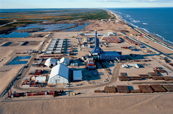
ExxonMobil built facilities for developing the Chayvo Field, part of Sakhalin-1
on Sakhalin Island, as a part of its activities in Russia. Recent Russian government
policies may hamper Western companies’ activities in the country. Courtesy
of ExxonMobil.
The policy, for example, could potentially keep Sakhalin-3, a giant offshore
oil field up for leasing this year, from being developed by Exxon, and seems
to affect the interests of TNK-BP, which has a 50-50 operating agreement between
Russian-owned TNK and English company BP, according to the Financial Times
and others. But at the moment, the situation in Russia remains uncertain, as
the Ministry of Natural Resources seems to be backing off the policy.
“It’s too early to gauge the reaction” to the recently announced
policy or its potential impacts, says Robert Ebel, chair of the energy program
at the Center for Strategic and International Studies (CSIS) in Washington,
D.C. However, he says, “I would look at it as a small step backward.”
Even though the new policy will not affect companies already operating in Russia
under contracts, Ebel says, major oil companies are still looking to the unused
potential of Russia’s oil fields for future investments. And because Russia
has neither the money nor the technology to improve its fields, particularly
in its oil-rich Arctic and offshore regions, foreign companies will be necessary
to future development there, say Ebel and others.
The decision to control foreign investments smacks of a continuation of the
crackdown seemingly initiated with the dissolving and re-nationalization of
Yukos, says Gal Luft, co-director of the Institute for the Analysis of Global
Security in Washington, D.C. “The Yukos affair really shattered perceptions
about Russia, [and] brought about a suspicion and lack of trust that is really
important in this business.” (See Geotimes, February
2005.)
Luft says that because oil prices currently are so high (at $55 a barrel as
of press time), most companies are not worried about investing in new exploration
or reserves in general. That comfort level also extends to the Russian government,
which gets 40 percent of its revenues from oil and gas, Luft says. All parties
“feel very comfortable,” he says, and feel no need for “urgency.”
PFC Energy analysts have tracked the Russian Ministry of Natural Resources as
it seemingly backtracks on the 51-percent rule after a “firestorm”
of criticism, inside and outside the country. And in a PFC Energy report in
March, analysts raised further doubts about Russia’s federal oil policy.
They noted that the merger plan for Gazprom and Rosneft, two of Russia’s
biggest state-owned oil and gas companies, “suffered a setback” as
company officials “feuded openly over the terms just hours after they were
announced.”
In the midst of these activities, western companies might stay away no matter
what the country’s policy on new bids. “It is not a good season for
them to go into Russia until things clarify, and we realize whether there are
good practices in place,” Luft says. And in the meantime, Russia is turning
to face the East rather than the West, where interest in its oil from China,
Japan and India has heightened.
Naomi Lubick
Links:
"Yukos
under fire," Geotimes, February 2005
Back to top
One of the primary ways to find hydrocarbon deposits on land is seismic surveying,
which can involve a crew of hundreds of people, a fleet of large trucks, seismic
energy sources and thousands of “geophones” to measure sound waves
as they travel through Earth. It’s a relatively expensive endeavor, and
one that’s not guaranteed to find hydrocarbons, says Stephen Coulson, head
of the European Space Agency’s (ESA) Earth Observation Market Development
program. So some oil and gas exploration companies are looking for ways to increase
the likelihood of successfully imaging the subsurface. For the past three years,
ESA and surveyor WesternGeco have partnered up for one approach: combining satellite
images with seismic surveying.
Seismic technologies can image and characterize the subsurface down to about
6 kilometers. They not only can locate potential reservoirs, but they also can
see geologic structures within the reservoirs. Because the technology is located
at the surface, it cannot image through some rock types, such as very soft or
very hard rock, and the seismic data may fail to give much information about
the subsurface. Satellite synthetic aperture radar from ESA’s ERS and Envisat
satellites can directly image those rocks and help seismic surveys obtain a
more detailed and diverse look at what’s belowground, Coulson says.
Using satellite images in this way is “certainly cheaper and easier than
physically going to remote locations,” says Peter Duncan, president of
MicroSeismic, Inc., in Houston, Texas. And satellite images can provide different
types of information that might be helpful in oil and gas exploration, Duncan
says.
Images of vegetation can reveal the geochemistry of the soils, while images
of the topography at the surface can reveal the geology at depth. And gravity
maps can detail the subsurface extensively, which is the only true way to see
subterranean structures such as reservoirs, Duncan says. The other things satellites
can show, says John LaBrecque, manager of the Solid Earth and Natural Hazards
Program at NASA are the types of minerals at the surface and the lithology at
and below the surface.
Prior to seismic surveys in east-central Algeria, for example, on a 500-square-kilometer
satellite fly-through, WesternGeco could see surface geologic clues as to where
the surveys would and would not work. Digital elevation models, ground-cover
images and short-wave infrared data revealed a pronounced limestone outcrop,
while thermal infrared imaging showed buried mineral deposits and information
on the hardness and softness of the near-surface rock.
By looking at these factors all together, companies can “come up with a
map where it’s best to run seismic surveys,” Coulson says. “They
are not going to tell you where you’ll find oil, but they will tell you
where to stop wasting your time and money running expensive surveys that won’t
work.”
Megan Sever
Back to top
Donald Olson, the U.S. Geological Survey Garnet Commodity Specialist, has compiled the following information on garnet, a colorful mineral used as gemstones and sandpaper.
Garnet is the general name given to a group of complex silicate minerals, all
with isometric crystal structure, similar properties and chemical compositions.
Garnet occurs in every color of the spectrum except blue, but it is most commonly
red, purple, brown and green. Garnet necklaces dating from the Bronze Age have
been found in graves and also among the ornaments adorning the oldest Egyptian
mummies.
However, garnet’s angular fractures, relatively high hardness and specific
gravity, recycling potential, chemical properties (it is inert and nontoxic),
and lack of crystalline silica, make it ideal for many industrial applications.
While some people may be familiar with industrial garnet from its use in sandpaper
and nail files, the largest industrial uses are in abrasive blasting, waterjet
cutting, water filtration, abrasive powders and anti-slip coatings.
Garnet resources are large and occur in a wide variety of rocks, particularly
in gneisses and schists. The mineral also occurs in veins and other contact-metamorphic
zones in limestones, pegmatites and serpentinites. In addition, alluvial garnet
is present in many heavy-mineral sand and gravel deposits throughout the world,
and is the source of most U.S. industrial garnet.
In 2004, total world industrial garnet production was estimated at over 440,000
metric tons, with Australia, Canada, China, India and the United States as the
leading producers. The United States produced about 6.5 percent of the industrial
garnet mined worldwide, with three mines in Idaho and New York providing an
estimated 28,400 metric tons valued at $3.05 million in 2004.
In 2004, the United States imported about 34,600 metric tons and exported approximately
11,000 metric tons. U.S. consumption in 2004 was about 56,700 metric tons.
During 2004, seven mines located in California, Idaho and Montana produced an
estimated $56,000 worth of gemstone garnet. Other U.S. mines in Alaska, Arizona,
Colorado, Connecticut, Maine, New Hampshire, New York, North Carolina, Pennsylvania,
Oregon and Virginia have produced significant gem garnet commercially in the
past.
For more information on garnet, visit minerals.usgs.gov/minerals.
 |
Geotimes Home | AGI Home | Information Services | Geoscience Education | Public Policy | Programs | Publications | Careers |