
The surprising strength of the magnitude-9 earthquake that triggered the destructive tsunami in Sumatra in December 2004 gave seismologists new urgency to discover characteristics that lead up to very large events. New models show that responsibility might rest on sediments that sometimes collect kilometers deep at the junctions of tectonic plates.
 Sediments
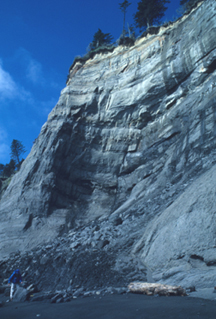
erode from a cliff located along the Olympic Coast in the state of Washington.
Similar types of sediments are filling basins underwater, and could be a contributing
factor behind large subduction-zone earthquakes. Image courtesy of Christopher
Fuller.
Sediments
erode from a cliff located along the Olympic Coast in the state of Washington.
Similar types of sediments are filling basins underwater, and could be a contributing
factor behind large subduction-zone earthquakes. Image courtesy of Christopher
Fuller.
Subduction zones, where two plates meet and one pushes below the other, have hosted many of the worlds largest earthquakes, including the Sumatra event, Kamchatkas magnitude-9.0 earthquake in 1952 and Chiles magnitude-9.5 earthquake in 1960, according to the U.S. Geological Survey. Yet other regions along subduction zones rest quietly.
A reason for the variation is evident in previous experiments that show that portions of subduction faults slip regularly, allowing stress to dissipate and making strong earthquakes less likely. In other locked portions of faults, however, stress tends to build, which can lead to large earthquakes when they finally slip.
How long plates stay locked together determines an earthquakes ultimate size, says Christopher Fuller, a seismologist at the University of Washington in Seattle. And according to new models that Fuller and colleagues put together, sediments help plates maintain their strength and stay locked, potentially leading to large earthquakes.
The models, published in the February Geology, have spurred Fuller and colleagues to consider new hypotheses that could one day help researchers determine where large earthquakes are most likely to strike. But just as important, Fuller says, the models put down a really simple explanation for a really complicated process.
Fullers team modeled plate strength in two computer simulations that show the cross section of a plate subducting beneath another plate, creating a bowl-shaped depression on the upper plate. The models suggest that when sediments are present, the upper plate is actually strengthened and deforms less than upper plates without sediments. These stronger plates, Fuller says, set the stage for larger earthquakes by allowing them to stay locked longer.
The correlation is evident to varying degrees in both the Kamchatka and Sumatra events, says Roland Burgmann, a seismologist at the University of California in Berkeley. The processes tested by Fullers models are fundamental to understanding subduction-zone earthquakes, Burgmann says.
Researchers are still uncertain, however, why some plates maintain strong stable contact for longer periods of times and trigger larger earthquakes. One idea centers around the idea of plate deformation. The more sediment loaded onto the top plate, the less it will deform and the more slip will occur at the plate interface.
Additionally, Fuller says, sediment on the top plate may keep the plate in stationary contact. The longer the plates stay in stationary contact, the more violent the result will be when the plates finally slip past each other. Conversely, smaller earthquakes are more likely to occur where the upper plate is not bearing sediment, as it is then free to slip more over time.
Another option is that sediments are controlling the movement of fluids that reside between plates. Under conditions free of sediment, mantle fluids can easily escape. Plates reinforced by sediment, however, make that escape more difficult, and pressure could build up until the fault finally fractures. Any of these processes could be occurring separately or together, Fuller says. Its really that we just dont know yet.
Fuller hopes that his models initiate discussion about why large earthquakes strike particular regions, and encourages seismologists to consider things that havent been considered before. Each basin, from Sumatra to Kamchatka, is a little different, he says.
Kathryn Hansen
 |
Geotimes Home | AGI Home | Information Services | Geoscience Education | Public Policy | Programs | Publications | Careers |