
The following is an excerpt from Remembering the Great Earthquake of 1906 in the July 1996 Geotimes:
When an earthquake destroyed much of San Francisco on the morning of April 18, 1906, studies to understand earthquakes and reduce their effects were in their infancy. In 1887, the first seismographs in the United States were installed at the University of California, Berkeley, and on Mount Hamilton; eleven years later, the San Andreas Fault was first recognized and named, but no one yet understood its significance.
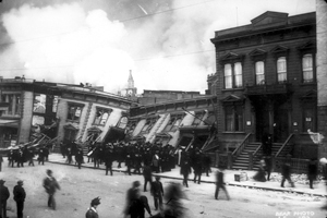
An unknown photographer took this photo of collapsed buildings somewhere in the Mission District, after a magnitude-7.8 earthquake, one of the largest to strike California in the past century, rattled the city of San Francisco in 1906. The earthquake and ensuing fires that burned for three days wrought millions of dollars in damage. Photo courtesy of Earthquake Engineering Research Center; Copyright © 2005 the Regents of the University of California.
Those few individuals who were involved in the relatively new science of seismology quickly journeyed to San Francisco that long ago April to see for themselves the effects of the disaster, to record their observations in scientific terms, and to hypothesize on its causes. Today, its clear that much of Californias success in learning how to live safely with earthquakes began in 1906.
News Notes
The San Andreas Fault ruptured early on the morning of April 18, 1906, in an earth-splitting magnitude-7.8 quake. Clocks stopped just after 5 a.m. in San Francisco and surrounding California communities. Fences split, houses collapsed, and water mains and gas lines broke. The fault broke from the coast at Point Arena, where it plunges into the Pacific in the north, all the way past the mission of San Juan Bautista in Hollister, and farther south to Parkfield (the site of U.S. Geological Survey experiments today). A total of 430 kilometers of fault slipped that day, as the Pacific side slid northward up to 5 or 6 meters in some places.
Geologists at the time had just figured out that faults were the source of earthquakes, and not the other way around. The teams of geologists who traced the effects of the earthquake and its parent fault down the length of California did not know that the San Andreas Fault, which would officially receive that name in 1907, marks the meeting point between two continental plates making the forces behind the so-called Great Earthquake huge.
The strongest shaking lasted about a minute, and aftershocks followed for days. Damage from the major shock was extreme in some cases, particularly on the sites built on made ground. Whole neighborhoods of the seaside city sat on fill that had been dumped on wetlands or in shoreline inlets to create land or just get rid of garbage. Builders continue to unearth foundations and other archeological treasures when digging into the soft sediments of the Marina District and elsewhere.
These human-made sediments liquefied in many places during the intense shaking of the 1906 event: As the waves passed through the deposits, particles shook loose and became suspended in the water that already was diffused throughout the layers. The land jiggled like gelatin, bringing down the two- and three-story wooden buildings in the Mission District, for example, causing many to pancake onto their first floors. Many people died in collapsing flophouses and businesses.
But its not the earthquake that people remember as destroying San Francisco. Instead, the ensuing fires that burned for three days are embedded in public imagination as the citys death knell. Waterlines and gas pipes ruptured, and the citys response at the time was not enough to prevent the conflagration. Some photos show limited damage to stone structures in the city, but many buildings were destroyed, whether by fire or on purpose, before engineers could get in to examine them.
The response from local and national politicians and businessmen led to what Gladys Hansen, San Franciscos official historian, and her co-author Emmet Condon, call the denial of disaster. In a book of the same name, Hansen and Condon lay out photos and other documentation detailing a cover-up of the earthquakes culpability, in ad campaigns and for insurance policy benefits that emphasized the fire as the main destroyer of the city. Hansen estimated that instead of the official number of about 300 deaths, some 3,000 people died for reasons directly related to the earthquake.
Some commentators today say that San Francisco is poised for some of these same kinds of disasters should another large earthquake strike the city directly. A few neighborhoods have invested in earthquake retrofitting, particularly in the Marina District, in some cases almost completely rebuilding the supporting framework of apartment buildings and houses so that they can withstand massive shaking. However, million-dollar apartment buildings on the bedrock hills above the city still have wide-open garages the same unsupported wooden frames that can collapse and pancake first floors.
Others point out that fire hydrants still lack the couplings that would allow fire companies from outside the city to hook up their hoses, and the waterlines are still at risk for rupture. The San Francisco Public Utilities Commission is now working on building earthquake-proof water pipes that cross the San Francisco Bay, carrying the regions water supply from the Hetch Hetchy reservoir farther inland. Pipes will have additional backup ducts that could be switched open should the main lines fail. That system, which provides water to the communities on the peninsula south of San Francisco as well as to the city (more than 2 million people), will not be fully functioning until 2010.
One well-known building from the 1906 earthquake still stands: The downtown federal courthouse that houses the Ninth District U.S. Court of Appeals came through relatively intact. Engineers recently retrofitted it with an innovative base-isolation system that put the stone building on rollers.
Seismologists currently estimate a 21 percent probability in the next 30 years that a big temblor will shake the city on the San Andreas Fault in the same way it did a century ago. But they also point out that the Bay Area is laced with faults that present even more immediate hazards.
The Hayward Fault, for example, which runs through the Oakland Hills and down the hills that rim the east side of the bay, last experienced a major seismic event in 1868. The magnitude-7.0 earthquake destroyed buildings in Hayward and San Leandro and damaged San Francisco. More than 30 people died throughout the region. Seismologists estimate a 27 percent likelihood of another large earthquake on that faultline in the next 30 years.
This month, the Seismological Society of America also celebrates its 100th anniversary, co-sponsoring a conference on the 1906 earthquake that brought the organization into existence (www.1906eqconf.org).
Sources: USGS; After the Earth Quakes, by Susan Hough and Roger Bilham; American Geophysical Union annual meeting, 2005.
 |
Geotimes Home | AGI Home | Information Services | Geoscience Education | Public Policy | Programs | Publications | Careers |