
Mount Vesuvius looms large above Naples and the Campania region along the western coast of Italy, serving as an ominous reminder of the cities and Italian citizens it buried during its infamous A.D. 79 eruption. However, another threat lies hidden beneath the coastal region a giant magma chamber. As the magma moves deep belowground, the land above it also moves, and new research is showing that such changes are more variable than previously thought.
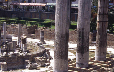 Dating of fossilized mollusk boreholes in Roman columns, shown here
in Pozzuoli, Italy, is giving researchers a better idea of when and by how much land has risen and fallen over
the years above a massive magma chamber on the Neapolitan coast. Photo courtesy of Nick Marriner.
Dating of fossilized mollusk boreholes in Roman columns, shown here
in Pozzuoli, Italy, is giving researchers a better idea of when and by how much land has risen and fallen over
the years above a massive magma chamber on the Neapolitan coast. Photo courtesy of Nick Marriner.
The magma chamber feeds Campi Flegrei, or the Phlegrean Fields, an active volcanic complex that since its formation has erupted massively twice, around 39,000 years ago and 15,000 years ago, with smaller eruptions as recently as 1538. In the oldest event, the volcanic complex erupted 200 cubic kilometers of magma an amount that would bury nearby Naples to a depth of 60 meters if it happened today. Vesuvius, by contrast, erupted approximately 3 cubic kilometers of magma in A.D. 79, says Daniel Morgan, a volcanologist at the Université Joseph Fourier of Grenoble in France.
The eruptions since then have not come anywhere near the size of early eruptions from the complex. Yet Campi Flegrei has serious potential to cause large amounts of damage if it were to erupt again in the heavily populated region, Morgan says.
The town of Pozzuoli (population around 80,000) is at the center of the volcanic complex, and over the years, the land there has risen and sunk repeatedly over short timescales, Morgan says. In 1984, Pozzuoli was evacuated after a series of shallow earthquakes, none of which topped magnitude 4, and a very intense period of uplift that resulted in more than 1.8 meters of inflation in less than two years. The quakes and uplift, however, mysteriously stopped later that year, and the land then began to slowly sink. Except for a few brief periods of uplift, the last of which occurred in 2005, the land has been subsiding since, says Giovanni Orsi, a volcanologist at the Osservatorio Vesuviano in Naples.
Such land inflation and deflation has been recorded at Campi Flegrei since at least Roman times, according to Christophe Morhange of the Université Aix-Marseille in France and colleagues, reporting in the February Geology. But the repeated uplift and subsidence cycles had not been accurately dated, nor had researchers been able to determine the extent of the land changes. Given that ground uplift may represent a precursor of eruptive activity, Morhange and colleagues wrote, the researchers set about trying to determine a detailed reconstruction history of the complex, in hopes of further evaluating future risks.
Morhange and colleagues compared historical accounts of uplift since the first century A.D. with fossilized mollusk boreholes that they collected from various points on Roman columns in Pozzuoli, nearby volcanic cliffs and an excavated Roman cave. Because the locales experienced land rise and fall over time, the team radiocarbon dated the boreholes at the three sites to determine how much and when the land changed.
The researchers found that from its highest point to its lowest point about 10 meters below present-day sea level Pozzuoli has risen and subsided by an astounding 17 meters (56 feet) over the past 2,000 years. The deformation occurred over at least three distinct events, only one of which ended in an eruption the 1538 eruption of Monte Nuovo, the team wrote. In the days prior to that eruption, the ground swelled several meters.
Considering the amount of land changes that occurred without eruptions, Morhange and colleagues wrote, it seems that the history of deformation at Campi Flegrei is far more complex than previously thought. And perhaps, they wrote, noneruptive land uplift episodes might be the rule rather than the exception.
Neither Orsi nor Morgan is surprised by the results. Weve known that the ground has been going up and down for a long time, Orsi says, but putting numbers on the magnitude and timing of the events is very helpful in evaluating the hazards the caldera may pose today.
The next step would be to pin down the causes of the deformation, Orsi says. Morhange and colleagues do not posit any specific mechanism behind the inflation and deflation at Campi Flegrei. The leading hypotheses presented, however, are either that magma is moving toward the surface or that hydrothermal fluids moving through minute cracks in the subsurface cause expansion and contraction. Although no one knows the cause, one thing is certain, he says: Any deformation is ultimately brought about by magmas life at depth.
The volcanic risk in the Neapolitan area is one of the highest in the world, Orsi says, as the area is densely inhabited and surrounded by three active volcanoes: Campi Flegrei, Vesuvius and Ischia Island. Because all three are active, he says, researchers just have to keep an eye on them, and keep learning about past activity.
Megan Sever
Back to top
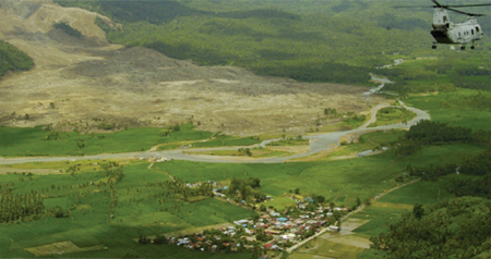
With merely a rumble, the slope of Mount Guinsaugon on southern Leyte in the Philippines gave way on Feb. 17, almost completely burying the village of Guinsaugon in more than 30 meters (100 feet) of mud and boulders. The landslide (seen in this aerial shot from a marine helicopter deployed to deliver relief supplies) killed more than 1,000 people, most of whom have not been found, according to a Feb. 20 Associated Press report. Storms in the previous two weeks had sopped the area, dropping 69 centimeters (27 inches) of rain on hillsides that were dangerously denuded from illegal logging in the 1970s through mid-1990s, officials told the Associated Press.
U.S. Navy Photo by Photographers Mate 1st Class Michael D. Kennedy.
As Leyte is often struck by tropical storms that bring floods and heavy rains into the mountainous area, landslides are common. Since 1991, thousands of people have been killed in floods and landslides on Leyte.
 |
Geotimes Home | AGI Home | Information Services | Geoscience Education | Public Policy | Programs | Publications | Careers |