
|
 Subscribe

NEWS NOTES
Adriatic still active
 Richard A. Bennett |
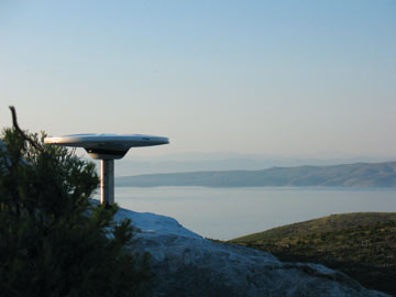
| A GPS station on the Dalmatian island of Hvar tracks the movement of the Croatian coast. |
Between the heel of the boot of Italy and the Balkan Peninsula lies the Adriatic Sea, an arm of the Mediterranean that contains some of the most beautiful islands in the world. Those islands, as well as the Dinaride Mountains that run parallel to the Croatian coast, formed millions of years ago as the Eurasian Plate plowed into a former piece of the African Plate, called the South Adria Microplate.
Geologists thought that the island-forming and mountain-building activity stopped some 20 million to 30 million years ago. But in 2007, Richard Bennett of the University of Arizona in Tucson and his colleagues discovered that Italy is, in fact, still inching toward the Croatian coast. Using GPS measurements that tracked the relative movements of the plates, the team calculated that Italy is slowly moving toward Croatia at a rate of about 4.5 millimeters per year.
Furthermore, to accommodate that motion, there must be a previously unknown but still-active fault extending for 200 kilometers beneath the Adriatic Sea, the team reported in Geology in January. At its southern end, just northwest of the ancient walled city of Dubrovnik, the fault connects to a well-known seismically active zone that has caused large-magnitude earthquakes in Dubrovnik and, farther south, in Montenegro, in historic times.
Although the newly discovered fault is not known to have caused any major earthquakes in the past 2,000 years, additional GPS stations in the region should help create accurate models of how the fault has behaved over the past 40 million years, the authors wrote. That information — specifically, whether the fault is slowly sliding or is building up strain before a sudden large slip — could mean reassessing the earthquake and tsunami potential of the region.

