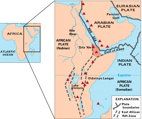
The East African Rift is the boundary between the west African, or Nubian, plate and the east African, or Somalian, plate. The area has been a troublesome part of the global tectonic puzzle. Geologists have speculated whether the Nubian-Somalian boundary simply terminates once it hits the Indian Ocean at the southern end of the East African Rift, or whether it continues beyond the Rift. And if it continues, theyve wondered, what direction does it follow?
Researchers have now established that the boundary continues into the Indian Ocean beyond the Rifts southern end. The Rift, which is the locus of east-west stretching from the separation of the Nubian and Somalian plates, transforms into seafloor spreading along the Southwest Indian Ridge off the eastern coast of South Africa. This piece of the tectonic jigsaw puzzle, which has alluded researchers for 35 years, has finally been found and put in place.
Reporting in the April 2002 Geology, Rice University geologists Richard Gordon and James Lemaux, now with BP Exploration Inc. in Alaska, along with geologist Jean-Yves Royer of the Institute Universitaire Européen de la Mer in France, unearthed the boundary between the Nubian and Somalian plates using measurements of magnetic anomalies from years past.
[Right: To see a larger image and explanation of this map, visit the USGS site.]
The greatest significance of this discovery is that we greatly narrowed the limits on where the Nubia-Somalia boundary intersects the Southwest Indian Ridge, effectively locating a boundary that had in previous interpretations defied the basic consequences of plate tectonics, Gordon says.
Gordon, Lemaux and Royer compared records of magnetic variations in the southern Indian Ocean seafloor. Because Earths polarity reverses roughly every 500,000 years, the seafloor appears as a series of bands that researchers can match up from opposite sides of the fault zone to gauge how far each plate has moved over a long time period. They studied the magnetic profile at 237 locations six times the number in previous studies and at 11 million years ago, determining how the plates moved relative to each other and pinpointing the location of the intersection of the Nubian, Somalian and Antarctic plates.
The land boundary between the Nubian and Somalian plates has always been tectonically active in the East African Rift, a virtual hotbed of seismic and volcanic activity. But where the Rift ends the boundary has been silent.
Very slow motion has now been detected between the Nubian and Somalian plates, compared with the Antarctic plate. Both the Nubian and Somalian plates are moving away from the Antarctic plate, at a relative movement rate between the African plates of only about 2 millimeters per year. While the rate is much slower than typical seafloor spreading and subduction, it is consistent with spreading at other plate boundaries around the Indian Ocean.
Gordon says that now that the boundary has been observed, the whole tectonic puzzle will likely change. A number of studies have, for example, estimated past motion between the Pacific and North American plates through the circuit: Pacific plate to the Antarctic plate to the African plate to the North American plate, effectively leaving out the motion between Nubia and Somalia, he explains. This motion needs to be incorporated into the tectonic model, which will change the results.
This finding should allow geologists to improve software models that predict tectonic motion, giving a clearer picture of what is likely to happen not only in the East African Rift valley, but also in other areas, such as the Himalayas and Tibetan Plateau where the Indian and Eurasian plates collide.
Meg Rudolph
Geotimes contributing writer
 |
Geotimes Home | AGI Home | Information Services | Geoscience Education | Public Policy | Programs | Publications | Careers |