
Geotimes Home | AGI Home | Information Services | Geoscience Education | Public Policy | Programs | Publications | Careers
 Now, exactly two centuries
later, President Bush is asking Congress to fund an expedition to survey the continent.
This time, however, instead of bringing guns, sextants and compasses to map the
surface, we will bring seismometers, satellites and GPS receivers to map Earth’s
interior. Bush is recommending that Congress fund EarthScope, a scientific survey
that will “investigate the structure and evolution of the North American
continent and the physical processes controlling earthquakes and volcanic eruptions.”
Now, exactly two centuries
later, President Bush is asking Congress to fund an expedition to survey the continent.
This time, however, instead of bringing guns, sextants and compasses to map the
surface, we will bring seismometers, satellites and GPS receivers to map Earth’s
interior. Bush is recommending that Congress fund EarthScope, a scientific survey
that will “investigate the structure and evolution of the North American
continent and the physical processes controlling earthquakes and volcanic eruptions.”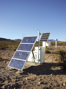 Data from all EarthScope
components will be integrated to produce models of continental structures and
to determine how those structures evolve. The seismological and drilling components
will yield detailed images of Earth below the surface. The GPS, strain meter and
radar images will allow us to view changes in those structures through time.
Data from all EarthScope
components will be integrated to produce models of continental structures and
to determine how those structures evolve. The seismological and drilling components
will yield detailed images of Earth below the surface. The GPS, strain meter and
radar images will allow us to view changes in those structures through time. Unanswered questions
While plate tectonics has provided us with a strong framework for our general
understanding of Earth, many questions persist about the structure of the North
American landmass, how it was formed and what forces are acting upon it. How
are the complex fault systems of the western United States organized to accommodate
overall tectonic plate motions between the Pacific and North American plates?
To what extent is mantle underplating responsible for relatively thick crust
in the Basin and Range (30 kilometers), despite 200 to 300 kilometers of crustal
extension? How did the Rocky Mountains form and what role does mantle flow play
in supporting them? Is earthquake activity in the “stable” mid-continent
region near New Madrid, Mo., related to the early development of the North Atlantic
Ocean more than 500 million years ago?
Seismic and geodynamic models of the mantle suggest that a major feature beneath
the North American plate is the Farralon plate, a piece of oceanic lithosphere
that was subducted beneath the continent. Images derived from EarthScope
seismic data will make it possible to determine more precisely the effect the
subducted Farralon plate has on North American geology. Preliminary GPS measurements
suggest little deformation in the North American continent east of the Rocky
Mountains. EarthScope GPS measurements will address the apparent discrepancy
between the lack of strain accumulation east of the Rockies and the historic
record of large earthquakes in areas such as New Madrid, Mo., and Charleston,
S.C.
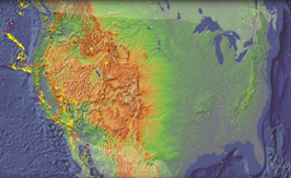
The tectonic history of North America spans at least 3 billion years. Models
for its formation include plate tectonic mechanisms, such as the collision of
island arcs; and non-plate tectonic mechanisms, such as large-volume magmatism
associated with mantle-plume eruptions. The formation of continents, the mechanical
response of continents to the forces of mantle convection and plate tectonics,
and the long-term survival of continents at Earth’s surface are intimately
linked to crustal properties, and to interactions between the crust and the
underlying mantle. EarthScope will provide the first continuous, high-resolution
images of the lithosphere at the continental scale to allow us to determine
the structure, deformation and evolution of the North American continent.
Quakes: More people, more risk
Our national infrastructure is growing at an exponential rate in many areas
of high seismic risk. The cost of earthquakes — and the federal government’s
liability — is growing proportionally. For example, the ten-fold increase
between the cost of the 1971 San Fernando earthquake ($2 billion) and the 1994
Northridge event ($20 billion) in southern California mostly can be attributed
to the region’s increase in wealth density over that time. A repeat of
the magnitude-8.0 earthquakes that hit along the Mississippi River in the central
United States from 1811 to 1812 today would result in losses exceeding $100
billion.
Our cities and towns are being built over complex fault systems consisting of
hundreds of independently moving sections, many of which remain unidentified.
These systems are not just along the plate boundary of the western United States
and Alaska. Zones of weakness prone to earthquakes are known to exist along
the Mississippi River, the coastal regions of the southeastern United States,
and in parts of New England and the North American seaboard. The historical
record of North America’s earthquakes is short, and other such zones may
have been subject to large, but as yet unrecognized, pre-historical earthquakes.
We have seen major progress over the past decade in understanding how faults
rupture and what ground motions earthquakes generate. But what remains remarkably
incomplete is our understanding of what controls an earthquake’s size,
why great earthquakes occasionally strike plate interiors, and when and where
the next major events might occur.
Seismic hazard analysis is a strong benefit of EarthScope’s multidisciplinary,
integrative approach. Seismic data will provide fault locations, fault geometries,
seismic velocities and subsurface structure. Geodesy, coupled with geochronology
and paleoseismology, will provide regional deformation patterns and fault slip
rates. Drill-hole data, combined with seismic recordings, will be tools for
developing fault rupture scenarios needed for ground-motion simulations. Ground
motion measurements are key for designing structures that can withstand earthquakes.
Individuals and groups of scientists will have access to a large, integrated
dataset for new research programs and activities.
It now lies within our grasp to forecast the critical aspects of earthquakes,
including probable locations of future, major events, and characteristics of
the ground motions they could generate. EarthScope will help us identify areas
where earthquakes are likely to occur and zones of deformation that contribute
to regional seismic hazards. The EarthScope dataset will help us measure rates
of deformation, install measuring stations on an active fault, and search for
evidence of sudden changes in strain or precursors that may presage potentially
damaging events. EarthScope may reveal whether slow stress waves from one earthquake
can propagate across the continent to load other tectonic systems, or whether
secondary events are dynamically triggered and isolated to areas characterized
by “soft spots” in the crust created by past geological events.
Volcanoes: Watching magma
Volcanic eruptions threaten more than 10 million people in the Pacific Northwest
and Alaska, and can endanger airline routes by choking jet engines with ash.
Volcanism also builds new continental crust either in situ or through the development
of island arcs on oceanic crust that are later accreted onto a continent. In
addition, the melt chemistry and xenoliths (fragments of the lower crust and
mantle rocks) of volcanic systems offer a window into the lower crust and upper
mantle.
We can use EarthScope’s seismic and geodetic data to quantify how quickly
magma accumulates in the upper crust beneath the several active volcanoes in
the Aleutian and Cascade arcs. Using these data, we will be able to determine
whether the accumulation is steady — over the time-scale of a few years
— or episodic. Does new magma move in a continuous trickle or as discrete
blobs?
Along the active subduction zones of Cascadia and Alaska, EarthScope’s
seismic data will be used to construct 3-D tomographic images of the down-going
slab, the asthenospheric wedge and the crust of the overriding plate. Changes
in velocity and attenuation are sensitive indicators of temperature and the
presence of melt. EarthScope may also detect vibrations induced by the flow
of magma and the breaking of rock as magma flows through it.
A map beneath the surface
Although we know that the lithosphere and mantle both play important roles in
continental dynamics, we still know little about the structure beneath continents.
EarthScope will provide the first high-resolution, tomographic images of Earth’s
interior at the continental scale, linking geologic features on the surface
to structures deep below. Variations in the depths at which seismic waves change
velocities in the upper mantle are clues to the composition, temperature and
chemistry of different tectonic provinces. EarthScope data will allow us to
map these regions at a high resolution.
A long-standing question about the North American continent is: How closely
are mantle flow and lithospheric deformation linked? By mapping how seismic
waves change as they travel different directions, we can discern mantle flow
patterns. EarthScope will give us the multi-directional data we need to map
structures beneath the continent.
Going deeper, researchers have occasionally reported finding that seismic waves
change velocities below the upper mantle at depths of 1,000, 1,200 or 1,800
kilometers. Such discontinuities could have a significant impact on our modeling
of convection and flow within the mantle. Understanding the processes that occur
along the boundary between the mantle and core is essential to modeling the
mantle, the geodynamo and Earth’s magnetic field. Some studies of the deep
Earth have suggested that the structure of the inner core varies at differing
scales. Measuring how fast and in what form seismic waves from distant earthquakes
travel through inner core, EarthScope provide high-resolution information about
the structure and composition of our planet’s deepest interior.
The work of many
If Congress approves funding for EarthScope, NSF will issue project solicitations
through its Major Research and Equipment and Facilities Construction Account
for constructing and operating EarthScope. NSF will fund ongoing operations
and research through its Earth Sciences Division and Geosciences Directorate.
Consistent with their usual mode of research funding, NSF and other agencies
will announce funding opportunities for individuals and groups. EarthScope will
be a large dataset for all researchers. Through the EarthScope dataset, we can
combine our research and create an integrated picture of the North American
continent’s formation and structure and, more importantly, how that structure
is deforming and changing.
Just as the Lewis and Clark expedition blazed the trail for future settlers
and traders, we will collect the dataset for the next generation of geoscientists
and educators. EarthScope will directly address many questions about the structure
and evolution of the continent. But perhaps one of the most exciting outcomes
of EarthScope will be the discoveries that at this point remain unpredictable.
|
Last year, the National Research Council published a report on the proposed EarthScope project. The report, entitled Review of EarthScope Integrated Science, was requested and funded by the National Science Foundation. It was produced by a committee led by George Hornberger of the University of Virginia. The following excerpts are reprinted with permission from the National Academy of Sciences. “The committee concludes that EarthScope is an extremely well articulated project that has resulted from consideration by many scientists over several years, in some cases up to a decade. During that time, the proponents have become experts, not just in the observing technology but in the data handling and retrieval systems that are necessary to manage information on this vast scale.” “EarthScope has the potential of providing scientific and technological leadership to the world’s seismological community. This integrated system for looking into the subsurface realm of a significant part of the North American continent could be used as a model for the other continents — Africa, Asia, Europe, Australia, South America and Antarctica.” “The committee concludes that EarthScope will have a substantial impact on earth science in America and worldwide. It will provide scientists with vast amounts of data that will be used for decades.” “The time is right to undertake a full exploration of the nature of the continental crust of the United States and its underlying mantle. Such exploration is a critical requirement for understanding the nature of the earth on which we live and how society needs to manage and adapt to its rhythms and processes.” “EarthScope provides an excellent opportunity to excite and involve
the general public, as well as K-12 and college students, to work together
with the earth science community to understand the earth on which they
live.” “The NSF should ensure that EarthScope’s scientific potential is effectively realized and capitalized upon by continuing its support for the disciplinary and interdisciplinary programs within NSF’s Division of Earth Sciences (EAR) that form the scientific foundation of the project.” “The committee concludes that InSAR is an integral part of the EarthScope vision that will greatly enhance the effectiveness of the project, and it should not be viewed merely as a desirable add-on to the project. The committee urges NSF and NASA to collaborate to realize this goal at the earliest opportunity, so as to make InSAR capability a reality during the lifetime of the other EarthScope components. Read the National Academies
report online. |
The EarthScope program plan and the ideas presented in this article have been developed by a broad segment of the U.S. university community — in collaboration with NSF, the U.S. Geological Survey and NASA — through a series of steering committees and workshops. For more information, visit the EarthScope Web site.
|
Geotimes Home | AGI Home | Information Services | Geoscience Education | Public Policy | Programs | Publications | Careers |