Geotimes
Web
Feature
Science
on Tribal Lands
Susan M. Marcus
 The land owned by
Native Americans in the United States would, all together, rank 11th in
a list of states by acreage. Currently, the U.S. government holds about
56 million acres of land in trust for tribes and individuals. The Navajo
Nation alone totals 16 million acres, about the size of Maryland, Massachusetts
and New Jersey combined. Tribes may acquire land, so the amount of tribal
land is likely to increase. American Indians and Alaska Natives are not
only the First Americans, but they are also an important land-owning segment
of our nation.
The land owned by
Native Americans in the United States would, all together, rank 11th in
a list of states by acreage. Currently, the U.S. government holds about
56 million acres of land in trust for tribes and individuals. The Navajo
Nation alone totals 16 million acres, about the size of Maryland, Massachusetts
and New Jersey combined. Tribes may acquire land, so the amount of tribal
land is likely to increase. American Indians and Alaska Natives are not
only the First Americans, but they are also an important land-owning segment
of our nation.
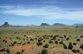
Pictured is Tsezhin Bii',
which means "within black rocks" in the Navajo language. This area of the
Navajo Nation, the largest Native American tribe in the Southwest, is also
near the Hopi Buttes area in Arizona. The butte-dotted landscape formaed
as a result of volcanic activity 7 million years ago. USGS scientists are
working with the Navajo Nation to conduct research in this area on how
climate variability affects land use. Humans have occupied this area since
at least A.D. 600. The trailer pictured in the foreground in home to Navajos.
Photo by George Breit
More than 2 million Americans identified themselves as American Indians
or Alaska Natives in the 2000 Census. More than 4 million identified themselves
as all or part Indian or Native American. This population group composes
more than 550 communities run by federally recognized tribal governments.
State governments recognize additional tribes, and the federal process
allows for recognizing more.
A major priority for these tribal governments is land management. Land
management requires scientific knowledge, particularly the knowledge offered
by geologists. Often, issues of tribal land management can become contentious,
particularly as tribal and nontribal governments must sometimes share resources.
But scientists can step in as objective providers of information.
The U.S. Geological Survey (USGS) provides reliable scientific information
to people who make decisions about lands and resources. Native American
land and resource managers use USGS information to respond to concerns
about human health, resource use and conservation. USGS information is
used by many parties involved with issues of tribal rights, notably water
rights.
Scientists have expertise based on formal education, field experiences
and the peer review process. Native American knowledge rests on experience
too centuries of it, usually distilled into oral traditions, wisdom and
culture. The scientists who work on tribal lands value the opportunity
to complement their scientific knowledge with Native American knowledge,
because both are rooted in close observation of earth processes that change
through time. Geologists, hydrologists and other earth scientists study
aspects of the land that are not bounded by political lines. Tribal lands
share attributes with other lands, but they are not public or federal
property. Tribal governments are defined as domestic dependent sovereigns,
and thus control access to their lands. In order to gain access to these
lands and to do science on them, USGS scientists are learning to explain
the rationale of our studies and the uses of our information to people
whose values may differ from those of other USGS cooperators and stakeholders.
This has meant learning new ways of applying our craft. Scientific culture
relies on reproducible data and shared information; it may include perceptions
of a world with humans at the top. The cultures of Native Americans vary
extensively, though most have a worldview that perceives all of Earth,
including humans, as integrated. Experience and observation are valued
as ways to understand the land and its inhabitants together.
Earth scientists and Native Americans both value experiential learning
and gain wisdom from experienced leaders in the field. Like other land
managers, tribal governments want information to manage their lands wisely,
and often want to know how present actions may affect seven generations
into the future.
Information for a
key resource
Water is crucial to the health of any community, particularly on tribal
lands. The quality of surface water and groundwater directly affects human
and environmental health now and for generations. The majority of tribal
lands in the conterminous United States are in semi-arid regions, where
water is a scarce resource. Due to economic and cultural conditions, tribal
communities rely on nearby land and water for much of their subsistence.
Spiritual practices related to land, water and animals are crucial to their
survival and culture.
USGS stream monitoring for sediment, contaminants, flow rates and water
use are important information sources for tribal governments and the Bureau
of Indian Affairs. Tribes use the data to set irrigation policies, address
public health concerns, and negotiate with other water users. USGS also
is helping several tribes develop their own stream gaging and monitoring
capabilities.
USGS studies of water contamination affecting tribal lands stretch from
Maine and Florida to from Washington and Alaska. The Oglala Lakota, Keweenaw
Bay Indian Community, and the Menominee Tribe of Wisconsin are among the
tribes that have worked with USGS to delineate sources of safe drinking
water.
Several tribes with groundwater contaminated by hydrocarbons or by saline
water that infiltrated into groundwater when hydrocarbons were extracted
nearby. USGS scientists have been working recently with the Assiniboine
and Sioux Tribes of the Fort Peck Indian Reservation in Montana. They have
identified that the reservations groundwater is contaminated by saline
water and by large nitrate concentrations. Saline-water contamination in
the East Poplar oil field not only discharges to the Poplar River, but
it also may include as much as 12.4 square miles and may affect 9 to 60
billion gallons of groundwater.
The probable source of saline-water contamination is brine that is
a byproduct of the production of crude oil in the East Poplar oil field.
Another study found that nitrate concentrations in more than 50 percent
of the groundwater wells completed in the Flaxville and underlying aquifers
exceeded the EPAs safety standard of 10 milligrams per liter.
The last sampling period was in 1993, and hydrologists need to perform
monitoring to determine whether the saltwater plumes in the East Poplar
oil field have migrated since then. They also need to take more samples
to determine if nitrate concentrations vary seasonally or over longer periods
of time. And, determining changes in groundwater quality requires a long-term
groundwater sampling network. The multiyear monitoring program now underway
will help the tribes use data collected by USGS scientists to assure that
their people have healthy, potable water.
The people of the Penobscot Nation in Maine use river fish for sustenance
and cultural reasons. With information on the occurrence and distribution
of dioxins, furans and polychlorinated biphenyls (PCBs) in fish and sediment
in the Penobscot River, the Penobscot Nation and others can make decisions
on ecological and human health risks.
Sampling by the Penobscot Nations Department of Natural Resources quantified
concentrations of dioxins and furans in the riverbed sediment to a limited
degree. In 1999, the Bureau of Indian Affairs brought together agencies
including the Penobscot Nation, USGS, EPA, the Maine Department of Environmental
Protection and the University of Maine Water Resources Research Institute
to study the rivers water quality. The results of this multi-party evaluation
will help the Penobscot manage resources and care for the health of their
people. Other jurisdictions may also use the information for land management
decisions.
USGS is conducting geological and geophysical studies to provide a framework
for understanding aquifers in several critical groundwater basins along
the Rio Grande, which extends from Colorado to Mexico. The diverse users
of water, overseen by tribal, state and local governments, need information
for making water claims.
The current focus is the Española groundwater basin in the greater
Santa Fe, N.M., region that includes lands belonging to the several Pueblo
Indian tribes, or pueblos.
USGS scientists are developing a 3-D view of the groundwater basin that
will eventually improve our understanding of groundwater flow and resources.
The project includes geologic mapping in cooperation with the New Mexico
Bureau of Geology and Mineral Resources and the University of New Mexico;
geophysical mapping of the subsurface in cooperation with Los Alamos National
Laboratory and the Summer of Applied Geophysics Experience educational
program; investigations of how faults affect the aquifer system; and studies
of geologic history to predict the distribution of underground aquifers.
Geologic and geophysical maps of Pueblo areas provide information that
aid Pueblo governments in protecting groundwater and in assessing of water
and other natural resources.
In Arizona, USGS is studying how climate variability and land use affect
the Hopi Buttes region of the Navajo Nation. Researchers are examining
the current surficial and bedrock geology, soil and water quality, and
plant ecology in the context of the effects of human habitation over millennia.
Information for teachers and for local land use planning is part of the
project, including presentations given to Navajo governing bodies and schools
in the Navajo language. Tribal members are an integral part of the study
team. The Navajo Nation can use the historical, geological and biological
information in determining grazing policies and in mitigating human health
risks from domestic water supplies that might be contaminated.
Education and cooperation
 Working with
tribal organizations and educational institutions, USGS aims to provide
tribal governments and Native Americans with the technical capabilities
and knowledge they need to manage their lands (related article in the September
2001 Geotimes). And tribal leaders and educators recognize the need to
train new generations to walk not only in the world of their culture, but
also in the world of Western science.
Working with
tribal organizations and educational institutions, USGS aims to provide
tribal governments and Native Americans with the technical capabilities
and knowledge they need to manage their lands (related article in the September
2001 Geotimes). And tribal leaders and educators recognize the need to
train new generations to walk not only in the world of their culture, but
also in the world of Western science.
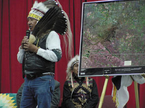
During the signing ceremony
for the agreement between Sinte Gleska University of the Rosebud Sioux
Tribe and the U.S. Geological Survey on Oct. 4, 2000, Albert White Hat
Sr. explains the significance of the ceremony and the relationship between
the two partners. The partnership means that USGS works with the university
on earth science education. Photo courtesy of USGS
Working with the Surveys EROS Data Center, Sinte Gleska University
on the Rosebud Reservation in South Dakota has created a curriculum in
geographic information systems (GIS). This collaboration provides training
for the students and provides land-planning information for the tribe.
USGS provided mentoring, data and internship assistance.
USGS started a GIS program at Haskell Indian Nations University in Lawrence,
Kan. With support from the Bureau of Indian Affairs, Haskell attracts Native
American students from throughout the United States. Using information
about tribal lands, the course has taught skills transferable to careers
in many fields, both on and off the reservation. Another cooperative effort
with Haskell was a short film, Mother Earths Story, which viewed the
science of geology from a Native American perspective. The film was created
for Native American high school and entry-level college classes, to encourage
the students to pursue careers in science, particularly in earth science.
The Federal Geographic Data Committee supports satellite broadcasts
of geospatial classes from the Southwestern Indian Polytechnic Institute
to tribal colleges throughout the West. The committee is supported by USGS,
the Fish and Wildlife Service, the National Oceanic and Atmospheric Administration,
and the Intertribal GIS Council and has created specialized courses on
building and maintaining a GIS.
Cooperation and collaboration with tribal governments and Native Americans
can benefit all parties. Tribal governments may not have the scientific
peer networks that scientists rely upon in many intergovernmental or cooperative
studies. All of us in the geoscience community should work toward building
those networks within the tribal community. We will benefit from such networks
because they increase the numbers and the understanding of the consumers
of our information. Tribes will benefit by having reliable information
to manage human health, resource and environmental issues. More cooperation
also will broaden Native Americans career options.
Geoscientists can inspire Native American students to pursue careers
in science by sharing our enthusiasm for studying Earth, through classroom
presentations and cooperative field studies. The next time you are near
a Native American school, whether it be a tribal college, university or
school for younger students, contact the science or natural resources teacher
and offer to give a presentation about your field or to demonstrate a field
technique. Take the opportunity to show them a wonderful, new world within
their own lands.
Marcus
is an American Indian/Alaska Native Liaison for the U.S. Geological Survey.
She works in the USGS Reston, Va., office. E-mail
For more information on USGS activities
related to American Indians and Alaska Natives, please visit the USGS
site.
