Geotimes
Field
Notes
Lake drilling out of Africa
Hydrogen on Mars
$150 for geosciences
Lake
drilling out of Africa
Lake Malawi in East Africa is one of the oldest and largest lakes on Earth.
More than 7 million years old and reaching depths of more than 700 meters, Lake
Malawi could provide climatologists with a unique window into Earth’s climate
past. At least that’s what Chris Scholz, associate professor of earth sciences
at Syracuse University, hopes.
The National Science Foundation’s Paleoclimate Program has given Scholz
and his colleagues $2 million to drill Lake Malawi and analyze its sediment
cores. The researchers hail from Syracuse University, University of Minnesota-Duluth,
University of Rhode Island and the University of Arizona.
“Lake Malawi is very large and very deep,” Scholz says. “And
it’s an extremely sensitive recorder of changes in climate.” Scholz’s
team will drill Lake Malawi at the southern end of the East African Rift Valley.
The drilled cores should help in constructing a continuous, high-resolution
record of past climates in the continental tropics over the past 800,000 years.
Although Malawi is an open-basin lake with an outlet, most of the water that
enters the lake does not flow out. Instead, the water evaporates. “So that
means that lake is extremely sensitive to any changes in the precipitation/evaporation
ratio, and that is reflected in huge changes in lake level,” Scholz says.
Early surveys reflect these lake-level changes, perhaps as large as 500 meters
over geological time. On a seasonal basis, he says, the changes could amount
to as much as 2 meters between wet and dry seasons.
“Another exciting reason to study this lake is that in certain areas it
contains annually laminated sediments,” Scholz says. “So we can potentially
have not only a very long record of geologic change, a very sensitive record,
but also one that’s recording changes on a year by year basis.”
But, Scholz adds, the site most uniquely distinguishes itself for the climate
record with its location as a continental tropical site. “There’s
a lot of data from the marine realm, but relatively little from the continental
tropics. So the global change research community really needs these reference
sites in order to constrain modeling efforts.” Lake Malawi is one of the
few Southern Hemisphere tropical sites, sitting between 9 and 14 degrees latitude.
“It’s also of course in the Great Rift Valley — it’s the
birthplace of mankind really.” So, Scholz says, the coring research could
provide a geological background for understanding the origin of early humans.
Lisa M. Pinsker
Hydrogen
on Mars
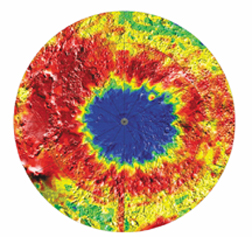
On Feb. 14, the
Mars Odyssey spacecraft successfully went into mapping orbit and began sending
back data. Some of these preliminary data indicated large amounts of hydrogen
near the southern pole of Mars, extending to 60 degrees south latitude.
Two weeks later, NASA released detailed maps confirming those preliminary findings
that the martian soil near the south pole is rich in hydrogen and could thus
represent water ice. Shown here is a view of the south pole of Mars seen with
intermediate-energy, or epithermal, neutrons. Deep blue colors on the map indicate
hydrogen-rich soil, or a low intensity of epithermal neutrons. This map comes
from measurements made by Odyssey's neutron spectrometer instrument.
Lisa M. Pinsker
Image courtesy of NASA/JPL/University of Arizona
$150
million for geosciences
The University of Texas at Austin announced March 2 that it has received what
it is calling the largest monetary gift ever made to a single public university.
The lucky department? Geoscience.
Retired oilman and geologist John A. Jackson pledged a portion of his estate to
the university, also his alma mater. The gift’s current worth is estimated
to be $150 million.
The money will support the John A. and Katherine G. Jackson School of Geosciences,
which combines the university’s Department of Geological Sciences, the Geophysics
Institute and the Texas Bureau of Economic Geology.
Last year, Jackson donated $25 million for starting the school, which launched
last summer, says William Fisher, a professor of geology at the university and
chair of the university’s Geology Foundation, which will manage the donation
(Geotimes, September 2001). Jackson also donated $15 million to the university
in 2000 for expanding the Geological Sciences Building.
“One of the biggest things we’re doing first is trying to put together
a more competitive package for graduate students,” Fisher says of the school.
“Our idea is to get the best students possible.”
Kristina Bartlett
