Geotimes

Geophenomena
Slip and slide
in Kentucy Dry spell in Eastern U.S.
Quake shows Turkey quick and nimble Web
Extras on recent large quakes
Slip
and slide in Kentucky
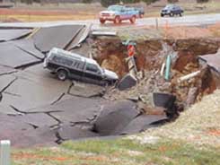 Geologists say stormwater
flushing and lubrication of an ancient collapse area underlying a section of Dishman
Lane in Bowling Green, Ken., caused 150 feet of the three-lane road to slide and
drop into part of a known underground cave system on Feb. 25. Four vehicles became
trapped on the road, with two of them falling into the opening of the sinkhole
at 5:15 p.m. But none of the occupants reported any injuries.
Geologists say stormwater
flushing and lubrication of an ancient collapse area underlying a section of Dishman
Lane in Bowling Green, Ken., caused 150 feet of the three-lane road to slide and
drop into part of a known underground cave system on Feb. 25. Four vehicles became
trapped on the road, with two of them falling into the opening of the sinkhole
at 5:15 p.m. But none of the occupants reported any injuries.
Not a through-street in Kentucky's karst terrain. Courtesy of Western Kentucky
University, Center for Cave and Karst Studies
Although no rain had hit the area in several days, the road, built only a year
ago, showed signs of sagging weeks earlier, says Joe Ray of the Kentucky Division
of Water in Frankfort. Bowling Green construction workers “drilled into the
road a week or two earlier to see what the story was, but those particular drill
holes didn’t tell them the collapse was coming. Nobody really knew it was
going to fall.”
Nick Crawford of Western Kentucky University’s Center for Cave and Karst
Studies had helped map the passages and rooms in the cave called State Trooper.
In 1988, using microgravity analysis, he showed city planners a large opening,
or cave room, existed under where they had proposed building part of the road.
But the cave hosted another large room: Mudderhorn Chamber, named for its two
interior mounds of mud that look like horns probing the 100-foot-wide, 200-foot-long
and 25-foot-high space.
During the 1988 geophysical investigation, Crawford drilled a well between the
first collapsed room and the Mudderhorn Chamber that showed more than 50 feet
of solid rock above the cave passage, and he recommended that the road cross over
the cave at that location. Although the planners designed their route to avoid
the first collapsed room identified by cave mapping and microgravity, “they
deviated from the Center’s proposed route when they got too close to Mudderhorn
Chamber,” Crawford says. But because of budget constraints, planners did
not ask Crawford to analyze the new route for low microgravity anomalies, which
show where spaces without rocks have less mass. “If we had, we would have
easily picked up that unstable part of the room that had already collapsed perhaps
thousands of years ago and was made of unconsolidated material,” Crawford
says.
Indeed, after the collapse, Crawford and other professional cavers were able to
canoe the underground stream through State Trooper Cave, passing blind fish and
white crayfish until they reached the broken road where they could then walk out
onto the surface through the new opening. At the point of the collapse, about
20 feet separated the road from the roof of Mudderhorn Chamber, but not all of
it was solid bedrock.
Just walking around the site, Ray, a karst hydrologist, saw that only boulders
were holding together some of the soil under the asphalt. “That particular
area was extra vulnerable because it appears to have previously collapsed,”
he says. “Rock and soil slid at an angle downhill into the cave. I saw about
10 feet of freshly broken cave roof sheared off by the slide. You might not have
been able to tell it was going to slide unless you drilled more holes to investigate
subsurface conditions.”
Drainage alteration and subsurface disposal of storm water runoff are getting
the blame for providing the flushing and lubrication that triggered the slide
and sinkhole. “Somehow we have to control our storm water runoff,” Ray
says.
Environmental geologist Michael May of Western Kentucky University agrees. Excavation
associated with the construction of the roadway and nearby buildings had funneled
storm water into the site, he says. “This change in the surface drainage
exacerbated an already metastable subsurface condition.”
In the process of shifting the unconsolidated material under the road, storm water
runoff may have also caused a water or sewer pipe to sag and rupture, further
decreasing the stability of the ground under the road, Crawford says. “We’re
still investigating the problem to determine how to repair the cave passage and
rebuild the road.”
Christina Reed
back to top
Dry
spell in Eastern U.S.
April showers will likely bring May flowers, but that doesn’t mean the
eastern United States will quickly rebound from the drought conditions that
have persisted throughout most of winter.
 According to
scientists at NOAA’s National Climatic Data Center, precipitation was near-normal
for the country overall from November to January, but below-normal rainfall
stretched from Florida to Maine, causing moderate to extreme levels of drought.
According to
scientists at NOAA’s National Climatic Data Center, precipitation was near-normal
for the country overall from November to January, but below-normal rainfall
stretched from Florida to Maine, causing moderate to extreme levels of drought.
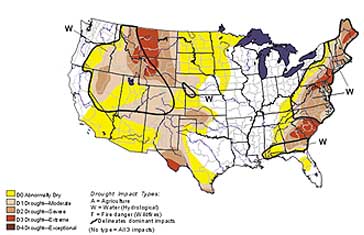
NOAA's
Climate Prediction Center's Drought Monitor from March 5, 2002, shows moderate
to extreme drought conditions along the East Coast. According to preliminary
data, the Northeast experienced the second driest September to February in 107
years of record. And New Jersey, Delaware and Maryland reported the driest February
on record. By Doug Lecomte, NOAA/CPC.
These drought conditions, says Frank Richards of the National Weather Service,
are the result of several relatively dry years along the East Coast. “And
in many parts of the East Coast, in particular from the Mid-Atlantic up through
southern New England and portions of Maine, there is a serious problem in terms
of reservoir storage. There is a serious problem in terms of stream levels and
there is a serious problem in terms of the water table,” Richards says.
In fact, water managers in many parts of the Mid-Atlantic and Northeast are
reporting near-record low stream flows and reservoir levels. Drought conditions
in Maine have dried up numerous wells and the 12 months ending in February were
the state’s driest in record. In January, the Delaware River Basin Commission
declared a drought emergency for the 13,539-square-mile watershed that drains
portions of New Jersey, New York, Pennsylvania and Delaware.
Since October, high-pressure weather systems have deflected storms from the
East Coast areas most affected by drought, robbing the region of needed precipitation.
Although February and early March saw some strong precipitation patterns in
the Southeast, the drought still persisted. In the spring, reservoirs in the
Northeast depend on the melting of winter’s snow packs. This past winter’s
below-normal snowfall will likely create an additional water debt for Northeast
reservoirs.
The West Coast has been experiencing a similar dry period for several years.
Despite near-normal precipitation patterns this past winter, the West is still
recovering from last year’s drought. But, Richards says, the West Coast
is better equipped than the East to handle multi-year droughts. Water reservoirs
there are larger to accommodate dry seasons.
Large reservoirs are expensive. On the East Coast, where long dry spells are
uncommon, reservoirs are smaller. “And it’s hard to justify it economically
— to build these huge reservoirs for something that happens once in a blue
moon,” Richards says. “So the shortfalls in rainfall on the East Coast
are dramatic, but maybe not as dramatic as on the West. However, because the
infrastructure is not able to accommodate it, the impacts are much greater.”
Long-term weather forecasts from NOAA’s Climate Prediction Center say occasional
storms should provide slow improvement heading into spring. But water shortages
will likely continue.
“Spring time almost invariably, even in a drought situation, is going to
bring some showers,” Richards says. “I suspect that unless we have
a lot of rain over a fairly prolonged period, we’re going to get to this
transition period where the perception on the part of most people is that the
grass is green, even a little soggy in their backyards — so what drought?
Yet the water managers’ reservoirs will not be full and they’re going
to be worried.”
Lisa M. Pinsker
back to top
Quake
shows Turkey quick and nimble
The magnitude-6.5 earthquake that shook west-central Turkey on Feb. 3 struck
a nation that already had vivid memories of the two consecutive quakes in 1999
that killed more than 17,000 people. But this time they were better prepared.
“Our state gained a lot of experience [since 1999],” Prime Minister
Bulent Ecevit told MSNBC. “For example, before the 1999 earthquakes our
civil defense organizations were not effective enough.”
The recent earthquake killed 43 people and injured about 300. Government authorities,
criticized for a slow response during the 1999 quakes, immediately began rescue
operations, rushed in mobile soup kitchens and first-aid posts, and delivered
tents, food and blankets. After the quake, seismologists began monitoring earthquake
parameters, says Ferhat Tasci, head of Turkey’s General Directorate of
Disaster Affairs Earthquake Research Department.
After the 1999 earthquakes, seismologists conducted geological ground investigations
to create an earthquake risk map showing land usable for construction and to
revise existing construction plans, Tasci says. Building codes were revised
after 1999, but the regulations apply to buildings yet to be constructed, he
adds. The 1999 earthquake mainly affected rural areas where most buildings razed
were old mud and brick houses, shops or government buildings.
At least eight aftershocks quickly followed the Feb. 3 temblor. Prime Minister
Ecevit urged people to stay out of damaged buildings. In Cay, hundreds of people
preferred to spend the night outdoors, or at a crisis center set up in a local
school, in fear of more quakes.
Neeta Bijoor
Geotimes contributing writer
back to top
Webextras
on recent large earthquakes
Powerful
quake shakes the Philippines
Large earthquake hits Afghanistan
back to top
