Geotimes

Web Feature
Rewriting History
with New Oilfield Technology
Robert A. Church, Daniel J. Warren, Andrew W. Hill and Jonathan
S. Smith
Editor’s note: The following story is modified from a paper
presented in May during the Offshore Technology Conference in Houston. It is
reprinted in this revised form with permission from C&C Technologies Inc.
In 1942, the world was at war and Germany controlled most of Europe. Hitler
launched Operation Drumbeat under the command of Adm. Karl Dönitz. Using
the might of Germany’s Unterseebootes, or U-boats, Operation Drumbeat would
take the war to the coasts of the United States, as Hitler’s predecessors
had done in World War I. This time the U-boats would not be limited to the East
Coast, but would extend right into the country’s backyard, the Gulf of
Mexico.
In May 1942, with the sinking of the U.S. battleship Norlindo by the German
U-507, a wave of destruction began in the Gulf of Mexico. Within just a year,
24 German U-boats entered the Gulf of Mexico, and 17 of them sent 56 merchant
vessels to the bottom and damaged 14 others. Two of the vessels that fell victim
to this onslaught were the freighters SS Alcoa Puritan and SS Robert E. Lee.
The Alcoa Puritan was a 6,759-ton cargo freighter 397 feet long and 60 feet
at beam. She was headed to Mobile, Ala., from Port of Spain, Trinidad, with
a load of bauxite. On May 6, 1942, she crossed paths with the U-507, commanded
by Horro Schacht. The U-507 sunk the Alcoa Puritan approximately 50 miles southeast
of the mouth of the Mississippi River.
 A few months
later, on July 20, 1942, the passenger freighter Robert E. Lee left Port of
Spain for New Orleans with approximately 270 passengers, 131 crew, six Merchant
Marines, and limited cargo. Most of the passengers were American construction
workers, their families and victims of other U-boat sinkings in the Caribbean.
They made their way though the Caribbean with a convoy, but after reaching the
Florida Keys they split from the convoy and continued through the Gulf of Mexico
with a U.S. naval escort, Patrol Craft (PC) 566. PC-566 was put into action
just five months earlier and outfitted as a sub-chaser. It was the first mission
for PC-566, and was the first naval mission of her captain, H.C. Claudius.
A few months
later, on July 20, 1942, the passenger freighter Robert E. Lee left Port of
Spain for New Orleans with approximately 270 passengers, 131 crew, six Merchant
Marines, and limited cargo. Most of the passengers were American construction
workers, their families and victims of other U-boat sinkings in the Caribbean.
They made their way though the Caribbean with a convoy, but after reaching the
Florida Keys they split from the convoy and continued through the Gulf of Mexico
with a U.S. naval escort, Patrol Craft (PC) 566. PC-566 was put into action
just five months earlier and outfitted as a sub-chaser. It was the first mission
for PC-566, and was the first naval mission of her captain, H.C. Claudius.
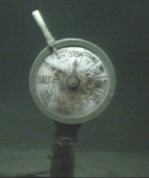
The telegraph from the bridge of the Robert
E. Lee was found standing upright on the seafloor and more than 200 meters off
the freighter’s port side. Image
courtesy of C & C Technologies Inc
The Robert E. Lee and PC-566 headed through the Gulf of Mexico toward Tampa
to take on provisions. Conditions onboard the Robert E. Lee were said to have
been horrendous and the passengers requested to disembark at Tampa. The captain
agreed, but when a pilot was unavailable to take them into the harbor, he decided
to continue on to New Orleans. The naval escort requested instructions from
the commander of The Gulf Sea Frontier and was ordered to continue on to New
Orleans with the passenger freighter. Just before midnight on July 29, 1942,
the Robert E. Lee and PC-566 left Tampa and headed for New Orleans.
At the same time, a German U-boat, the U-166, was patrolling the shipping lanes
off the southeastern coast of Louisiana. On July 27, 1942, the U-166, under
the command of Hans-Günther Kühlmann, radioed the German Naval Command
to say they had finished their mission of laying mines off the mouth of the
Mississippi River. This mission was the sub’s first war mission. Kühlmann
had known limited success during this patrol. He had sunk a 2,309-ton vessel
and two others that together totaled 100 tons. He was eager to add to his tonnage
sunk before heading home.
The Robert E. Lee and her escort steamed across the Gulf and were about 45 miles
southeast of the Southwest Pass of the Mississippi River. It was July 30, and
the summer day was clear and calm. At 4:30 in the afternoon, PC-566 was sending
a radio message to the Port Authority of New Orleans when a torpedo slammed
into the starboard side of the Robert E. Lee. The vessel began sinking quickly
and the naval escort, which had been running about half a mile ahead of the
Robert E. Lee, sprang into action.
PC-566 gained sonar contact on the U-boat and dropped two spreads of depth charges
across its path as it tried to dive. After the attack, an oil slick appeared
on the surface. The PC-566 crew, after sweeping the area without regaining sonar
contact with the sub, determined they had either chased the sub from the area
or had sunk it. The operation, joined by the naval SC-519 and the pilot boat
Underwriter, turned into a rescue mission as they began pulling survivors from
the water. The survivors were taken to shore at Venice, La., but 25 people died
on the Robert E. Lee.
Two days later, on Aug. 1, a U.S. Coast Guard Grumman J4F seaplane was patrolling
out of Houma, La. The pilot was Henry White and his radio operator was George
Boggs. About 30 miles off the Louisiana coast they came through the clouds and
spotted a German U-boat on the surface. They radioed their position and circled
around to attack the enemy sub. The U-boat began to crash dive and quickly slipped
beneath the waves as White and Boggs deployed their only weapon, a single depth
charge. The charge detonated near the U-boat and White and Boggs reported a
light to medium oil slick on the surface. After returning to base they were
instructed that the incident was classified. A year later they were informed
that they had sunk the U-166 that day.
Unexpected find
For the next 59 years, the location of the U-166 remained a mystery. The area
in which it was thought to have sunk is one of the most heavily surveyed regions
on the globe. Remote sensing surveys for oil and gas development have crossed
the area numerous times. For decades groups have scoured the seafloor searching
for the U-166, but no trace of the U-boat was ever identified.
A combination of events would change this situation.
In January 2001, BP and Shell contracted C&C Technologies to survey a route
for the Okeanos pipeline. The 100-mile-long pipeline will carry natural gas
from fields deep in the Gulf and connect with the Destin pipeline, which goes
onshore in Mississippi. Shell reports that the Okeanos pipeline could carry
up to 2 billion cubic feet of gas per day and will be the first gas pipeline
in waters deeper than 6,000 feet.
C&C used its new HUGIN (High Precision Untethered Geosurvey and Inspection
System) 3000 AUV (Autonomous Underwater Vehicle), a deep-water survey vehicle
that carries a full array of survey instruments and is capable of faster and
more accurate surveys than conventional deep-tow systems.
The HUGIN 3000 is a third-generation AUV by Kongsberg Simrad and the first commercially
operated AUV capable of surveying in water depths reaching 3,000 feet. It is
integrated with a diverse payload of survey instruments: a swath bathymetry
system, side scan sonar, and a subbottom profiler. Because it is an untethered
system that runs on internal power, it can operate even in rough seas and at
faster speeds with greater mobility and accuracy than conventional towed arrays.
An inertial navigation system, coupled with an acoustic tracking system, makes
it possible to accurately steer the AUV. Surveying in 1,500 meters of water,
the HUGIN 3000 positioning is accurate to within 3 to 6 meters. Conventional
towed systems are typically only accurate to 30 meters or more at the same water
depth.
A serendipitous combination of factors set the scene for a unique archaeological
discovery. The HUGIN 3000 can travel deeper than most commercial AUVs. It can
navigate rough waters and is easy to maneuver, which means it can survey large
areas in short time periods. The data it collects is high quality. These technological
advantages, combined with the luck of where the Okeanos surveys took place,
made it possible to find some of history’s relics. The survey detected
a large shipwreck at the edge of the AUV’s survey corridor in 1,500 meters
of water. C&C marine archaeologists Robert A. Church and Daniel J. Warren
contacted archaeologist Dave Ball at the MMS to verify the identity of the vessel
as the Robert E. Lee. In order to satisfy engineering concerns of routing a
pipeline near a potential debris field, and out of a sense of duty to preserve
sites of historical or archaeological significance, BP and Shell sponsored a
second investigation survey around the Robert E. Lee and the suspected location
of the Alcoa Puritan. BP’s Rick Davey proposed a region grid survey, which
was far beyond the few investigation lines the archaeologists had hoped for.
Because the survey could be conducted quickly with the AUV while in the area,
the oil companies decided to have C&C conduct a 2-mile by 1.5-mile investigation
survey in the area to precisely position any wreckage or outlying debris of
both shipwrecks.
 C&C conducted
the first investigation survey in March 2001. The survey was 17 survey lines
at 150-meter line spacing for a total of 31.7 nautical line miles. Using the
AUV, the entire investigation survey took less than nine hours, a fraction of
the 80 or more hours a conventional deep-towed system would have required.
C&C conducted
the first investigation survey in March 2001. The survey was 17 survey lines
at 150-meter line spacing for a total of 31.7 nautical line miles. Using the
AUV, the entire investigation survey took less than nine hours, a fraction of
the 80 or more hours a conventional deep-towed system would have required.
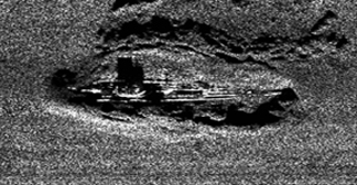
Side scan sonar at 410 kilohertz reveals
the sunken German submarine, U-166, in 2001. Image
courtesy of C & C Technologies Inc
As the C&C archaeologists analyzed the data, they realized that the scattered
debris identified as possibly being the Alcoa Puritan did not match the characteristics
expected of a 6,759-ton freighter. The sonar contacts consisted of two large
sections lying approximately 500 feet apart with debris of various sizes scattered
between them. The largest section of debris measured approximately 200 by 20
feet. The other major section measured approximately 55 by 20 feet. The combined
length of the two sections, 255 feet, was just over half the size of the Alcoa
Puritan (397 feet long by 60 feet at beam). Although they did not rule out the
Alcoa Puritan, Church and Warren hypothesized that the debris were actually
the U-166.
The U-166 was a Type IX-C U-boat, a type that measured 252 feet in length by
22 feet at beam. The sonar image, though not conclusive, was almost exactly
what the archaeologists anticipated seeing if they were so lucky as to come
across the U-166. Circumstantial evidence seemed to support the U-166 hypothesis.
The question remained, however, as to how the U-166 could be located more than
140 miles from where it was reportedly bombed, and within less than a mile of
the U-boat’s last victim. The answers began to fall into place when Warren
suggested that the two Coast Guard aviators had possibly bombed a different
U-boat. Research indicated three German U-boats were in the Gulf of Mexico on
Aug. 1, 1942: the U-166, U-509, and U-171. Evidence quickly pointed toward U-171
being the U-boat that White and Boggs had attacked.
The U-171, commanded by Günther Pfeffer, entered the Gulf on July 23, 1942,
and was operating between Galveston and New Orleans. Pfeffer’s focus was
to be on the Port of Galveston, but he found that the waters off Galveston were
too shallow and radioed that he was moving toward the New Orleans area. U-171
sank the R. M. Parker Jr. on Aug. 13, 1942, within three miles of where White
and Boggs made their attack on a U-boat. U-171 was operating in the right area
during the right time period to be that U-boat.
The archaeologists developed a new hypothesis to pinpoint the location of U-166
and to identify the U-boat that White and Boggs attacked. The evidence indicated
that the debris to the east of the Robert E. Lee were the remains of the U-166,
which PC-566 sank after the sub attacked the Robert E. Lee. That information,
combined with the historical research, further indicates that White and Boggs
bombed, but did not sink, the U-171 on Aug. 1, 1942.
After meetings among C&C, Shell, BP, the U.S. Coast Guard and the MMS, Shell
arranged for a Remote Operating Vehicle (ROV) to take a research team to the
wreck sites. Because of the importance of the historical find, BP and Shell
sponsored further AUV investigations of the Robert E. Lee and the suspected
U-166 sites.
On May 17, the C&C archaeologists looked deeper and with higher resolution.
This investigation ran 33 tracklines in 1,500 meters of water and in three different
directions. Each trackline was 450 meters long with 10 meters between each.
The survey ran much closer to the seafloor — within 15 meters — so
that the bathymetry beams were closely spaced. The result was a smaller horizontal
footprint per beam on the seafloor, thereby allowing depths to be resolved better
and increasing resolution. This tight grid pattern provided excellent data acquisition
for detailed examination, and took the AUV less than two hours to complete.
Such a survey would have been difficult to accomplish using a towed system because
of prohibitive cost and maneuverability.
The first two investigation surveys of the U-boat site collected side scan data
simultaneously, at both 120 kilohertz and 410 kilohertz. On May 26 and 27, we
conducted a third survey only in 410 kilohertz in order to increase resolution
by increasing the ping rate. The results of this survey were spectacular.
The revealing sonar and bathymetric data collected during the archaeological
investigations provided further evidence supporting the U-boat hypothesis. The
side scan sonar images in 410 kilohertz revealed the conning tower and other
features of a U-boat. The dimensions matched exactly with those of the U-166.
The side scan sonar image perfectly matched an outline of a type IX-C German
U-boat. The bathymetry data showed that the main section of debris was lying
in a 2-meter deep impact crater and that the section suspected to be the bow
had approximately 2 meters of relief above the seafloor. The next step was to
steer the ROV close to the wreck to visually verify and further document the
find.
A closer look
 On May 31, a
research team from BP, Shell, C&C and the MMS headed out to conduct an ROV
investigation of the Robert E. Lee and the U-166. Jack Irion, a marine archaeologist,
and Richard Anuskiewicz of the MMS joined the archaeologists from C&C and
the team of professionals assembled from Shell and BP. The research team used
the Gary Chouest, an anchor-handling vessel on contract to Shell and equipped
with an Oceaneering Millennium VI ROV.
On May 31, a
research team from BP, Shell, C&C and the MMS headed out to conduct an ROV
investigation of the Robert E. Lee and the U-166. Jack Irion, a marine archaeologist,
and Richard Anuskiewicz of the MMS joined the archaeologists from C&C and
the team of professionals assembled from Shell and BP. The research team used
the Gary Chouest, an anchor-handling vessel on contract to Shell and equipped
with an Oceaneering Millennium VI ROV.
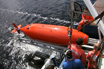
Retrieval of the
HUGIN 3000 AUV (Autonomous Operating Vehicle), the key tool in finding the real
location of the U-166.
Courtesy of C & C Technologies Inc
The ROV’s first glimpse of the vessel was the unmistakable conning tower
of a German U-boat. Clearly visible were the 105-millimeter deck gun and the
37-millimeter and 20-millimeter antiaircraft guns. Every feature videotaped
proved to match that of the U-166.
The investigation of the bow section provided a revealing look at what destroyed
the U-boat. A large indentation is visible in the top of the deck, and appears
to be the result of a depth charge explosion. Just aft of this damaged area,
the bow had torn away from the rest of the vessel. The serrated metal flares
outward as if ruptured by an internal explosion. Possibly a depth charge exploded
right on the deck and ruptured the pressure hull, which in turn caused an internal
explosion. It is speculated that either a torpedo or saltwater rushing into
the battery room could have caused such an explosion.
The ROV was then moved a mile west to collect detailed videos of the final resting
place of the Robert E. Lee, which had subsided into the seafloor so that the
torpedo damage hides below the mudline. The ROV recorded the deck gun on the
stern, two lifeboats lying off to the port side of the ship and the brass signal
bell on the bow. But the most spectacular find from the Robert E. Lee was the
ship’s telegraph, which was used to communicate from the bridge to the
engine room. The telegraph was found lying more than 200 feet off the port side.
It was alone, standing upright on the seafloor. Made of brass, it was in pristine
condition and most of the words on its face were legible. The engine room indicator
arrow was in the “STOP” position and the handle was back in the “FINISHED
WITH ENGINES” position, a command that was never executed.
Church and Warren are archaeologists
with C&C Technologies, Inc. Hill is a Geohazards Team Leader with BP Exploration
and Production Inc. Smith is a project leader with Shell International.
