Geotimes

Geophenomena
Dry
Spell
Drought
Floods break parched ground
Costly fires
 This
year, drought has held the country firmly in its grip. Across the United States,
communities face their worst water shortages in decades. Forest fires rage in
the western states: the Rodeo-Chedeski fires in Arizona and the Hayman fire in
Colorado made national news as they spread uncontrollably. Dust storms rise above
the plains of Nebraska, Kansas, Montana and Wyoming. Agriculture and ranching
has been affected in many states.
This
year, drought has held the country firmly in its grip. Across the United States,
communities face their worst water shortages in decades. Forest fires rage in
the western states: the Rodeo-Chedeski fires in Arizona and the Hayman fire in
Colorado made national news as they spread uncontrollably. Dust storms rise above
the plains of Nebraska, Kansas, Montana and Wyoming. Agriculture and ranching
has been affected in many states.
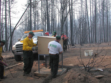
USGS scientists, working as part of the multiagency Burned Area Emergency Response
team, install a streamflow gaging station near the Apache Indian Reservation near
Show Low, Ariz., site of the Rodeo/Chedeski fire. The gaging stations dot the
country and monitor the changing levels of streams. These data make up an essential
component of the drought monitor map.
The Show Low station will supply the The National Weather Service River Forecast
Center in Salt Lake City with data for models of rainfall runoff. The Center will
use these models to give the towns of Cibecue and Carrizo warnings of impending
flood conditions that would result from erosion on fire-ravaged lands.
The federal view on drought has been to treat it primarily as an unforeseeable,
emergency event. This view is slowly changing. "In practice, yes, the drought
mitigation paradigm is new. This is evident in that only a handful — five
or six — of the 35 states with plans are recognized by us as being mitigative
in nature," says Mark Svoboda, a climatologist at the National Drought Mitigation
Center (NDMC) at the University of Nebraska-Lincoln.
 Under
the auspices of the NDMC and other federal, state and local agencies, understanding
of drought as a normal and recurrent aspect of climate is being emphasized so
that people are prepared for it. It is essential to understand drought not just
as a physical phenomena of prolonged deficiencies in precipitation, but also as
an interplay with human demands for water. This summer, drought continued to ravage
parts of the country, and allocated emergency funding to counter the situation
escalated (this year, more than half the states in the country had counties assigned
emergency farm loans). At the same time, scientists and policy makers are trying
to consolidate and enhance the resources available to monitor and mitigate drought.
Under
the auspices of the NDMC and other federal, state and local agencies, understanding
of drought as a normal and recurrent aspect of climate is being emphasized so
that people are prepared for it. It is essential to understand drought not just
as a physical phenomena of prolonged deficiencies in precipitation, but also as
an interplay with human demands for water. This summer, drought continued to ravage
parts of the country, and allocated emergency funding to counter the situation
escalated (this year, more than half the states in the country had counties assigned
emergency farm loans). At the same time, scientists and policy makers are trying
to consolidate and enhance the resources available to monitor and mitigate drought.
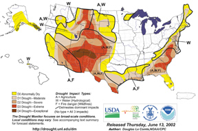
The drought monitor map, updated each month,
is the primary overview of drought status in the United States. It combines several
variables that contribute to drought. For example, it uses the Standardized Precipitation
Index, which incorporates data about stream flow, soil moisture, groundwater and
reservoir levels. This index balances out the Palmer Drought Index, which does
not consider irrigation impacts. The map combines data from the U.S. Geological
Surveyand other federal agencies. Click on the above map pr visit the drought
monitor online for the most recent version.
Salma Monani
Floods
break parched ground
After months of drought, July has topped the books for the wettest July in recorded
history for San Antonio, Texas. Around the country, relief from the drought has
come with a cost. Since mid-June, flooding has hit regions in Montana, Minnesota,
Wisconsin, Florida and Texas.
A flash flood near Ogallala, Neb., followed 10 inches of rain on July 6, damaging
Interstate 80. A truck driver from North Carolina died during the flood when his
vehicle plummeted off the roadway.
From June 30 through the first week of July, torrential floods inundated south-central
Texas, killing nine with one person still missing. Heavy rains dumped from about
4 to 34 inches across a 33,000 square mile region of the state. Gov. Rick Perry
estimated the cost of damages at $1 billion. In San Antonio, 15.72 inches of rain
fell during the first 11 days of July, breaking the month’s 1990 record of
8.29 inches.
Meteorologist Robert Blaha of the National Weather Service in Austin/San Antonio
says the flood didn’t happen soon enough to help the region. “It relieved
dry conditions considerably of course, but some crops planted in the winter were
already affected by the drought and the farmers will have to wait until next planting
rotation and then go from there.”
The good news is that the water supplies in the Texas Choke Canyon Reservoir and
Lake Corpus Christi are reaching full capacity for the first time in about a decade.
“For Choke Canyon, the floodwaters were definitely a benefit. The lake level
was down in excess of 20 feet. Floodwaters coming to this lake improve fisheries
and migratory waterfowl migration,” says Laird Fowler, program administrator
for Texas State Parks Division. “This is one silver lining out of all this.”
Christina Reed
back to top
Costly
fires
 According
to the National Interagency Fire Center (NIFC), as of June 19, the year-to-date
estimate for lands burned by wildfire was 1.75 million acres. The tally on the
same date for the year 2000, the worst fire season in nearly half a century,
fell just under 1.3 million acres while the 10-year average is 875,000 acres.
The costs of suppressing this year’s wildfires have already reached $141
million for the federal government. That number will only increase with time.
Currently, the estimated daily cost of fighting fires nationwide is approximately
$8.6 million. The cost of stomping out the year 2000 fires was more than $1.36
billion, a number that includes outfitting and paying firefighters and pilots,
equipment costs, fire retardant costs, and all expenses that go toward extinguishing
the flames.
According
to the National Interagency Fire Center (NIFC), as of June 19, the year-to-date
estimate for lands burned by wildfire was 1.75 million acres. The tally on the
same date for the year 2000, the worst fire season in nearly half a century,
fell just under 1.3 million acres while the 10-year average is 875,000 acres.
The costs of suppressing this year’s wildfires have already reached $141
million for the federal government. That number will only increase with time.
Currently, the estimated daily cost of fighting fires nationwide is approximately
$8.6 million. The cost of stomping out the year 2000 fires was more than $1.36
billion, a number that includes outfitting and paying firefighters and pilots,
equipment costs, fire retardant costs, and all expenses that go toward extinguishing
the flames.
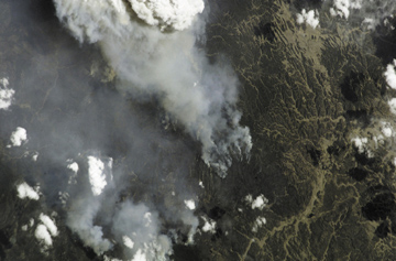
The Hayman, Colo., fire photographed from
space on June 18. JSC/NASA
Also by June 19, the Hayman wildfire burning outside Denver had razed more than
140,000 acres and amassed $15 million in suppression costs, according to the
NIFC. In addition to homes, electrical facilities and transmission lines, gas
pipelines, recreation areas and timber reserves are at risk.
Laura Wright
Geotimes contributing writer
back to top
