
 A new federal
report states that land in Louisiana and probably throughout the Gulf Coast
has been sinking at a relative rate of more than 1.5 meters (5 feet) per century
for at least the last 100 years — a rate significantly higher than previous
reports have shown. If that rate is correct and continues, it means much of
the coastline, including New Orleans, could be underwater by the end of this
century.
A new federal
report states that land in Louisiana and probably throughout the Gulf Coast
has been sinking at a relative rate of more than 1.5 meters (5 feet) per century
for at least the last 100 years — a rate significantly higher than previous
reports have shown. If that rate is correct and continues, it means much of
the coastline, including New Orleans, could be underwater by the end of this
century.
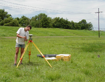
Tulane University geologist Torbjörn
Törnqvist sets up a GPS instrument in front of an artificial levee along
the Mississippi River in Louisiana. Based on detailed reconstructions of sea-level
rise, he and his students have found subsidence rates of about 10 millimeters
per century — two orders of magnitude less than the rate of 1.5 meters
(15 feet) per century published in a recent federal report. Courtesy of Juan
González.
Scientists agree that subsidence — the slow sinking of land — is occurring
along coastal areas of Louisiana, Mississippi, Texas and Alabama. Louisiana,
for example, loses an acre of wetlands every 35 minutes to inundation by the
sea and has lost 65 to 100 square kilometers per year for the past several decades,
according to the Louisiana Coastal Wetlands Conservation and Restoration Task
Force. More than 1 million residents and businesses in New Orleans are below
sea level and are at serious risk from subsidence, says Jeff Williams with the
U.S. Geological Survey (USGS) in Woods Hole, Mass.
Many restoration efforts have been undertaken to save the coastline, including
the Coast 2050 plan and the Louisiana Coastal Area plan, a $14 billion project
to restore the structure and function of the coastal wetlands. But as coastal
managers struggle to figure out how to mitigate problems, controversy keeps
arising over just how rapidly the land is sinking relative to sea level, and
why.
“Most scientists would agree that the subsidence is caused by a combination
of geologic and anthropologic factors,” Williams says. These factors include
natural fault movement, compaction of sediments, and withdrawal of oil and gas,
common in the oil-producing Gulf. But, he says, scientists don’t know what
the individual contribution of the factors is to the overall subsidence rate.
Roy Dokka of Louisiana State University in Baton Rouge, co-author of the new
subsidence report, says that the sinking is probably almost all natural and
thus likely to continue over the next 100 to 1,000 years. After all, he says,
“the bottom of the Mississippi delta is 100 meters down, and began to form
8,000 years ago, showing a natural compaction” of sediments at a rate of
12.5 millimeters per year.
Dokka and co-author Kurt Shinkle of the National Geodetic Survey (NGS), which
published the report, looked at benchmark leveling measurements from NGS archives
from 1920 to 1995, and then compared those data to tide-gauge measurements and
other independent datasets. The benchmarks, often brass disks attached to rods
stuck in the ground or on the sides of buildings, are points of comparison for
elevation measurements over time.
“Subsidence is much more widespread and much faster than previously thought,”
Dokka says. While these rates are specific to the past 100 years and “may
not reflect the current rate of subsidence,” according to the NGS report,
Dokka says that “you can’t extrapolate these rates without looking
at the future,” and he “absolutely” thinks the rates are natural
and will continue.
Many scientists, however, disagree. Rates this high are only possible locally
— and due to human influences — and are not likely to apply today,
says Bob Morton of USGS in St. Petersburg, Fla. Additionally, he says, “we
have good evidence that the highest rates of subsidence, near oil and gas withdrawal
sites, are in decline, and that wetland loss rates — which are closely
tied to subsidence — have slowed dramatically, leading us to infer that
overall subsidence rates may have also slowed dramatically.”
Indeed, other studies show a significantly slower rate of subsidence throughout
the region. Geologic data from old beach deposits in western Louisiana, for
example, have revealed a rate of about 1 millimeter per year, or 1 meter per
1,000 years (almost 100 times slower than the NGS report), says Kristy Milliken,
a graduate student at Rice University in Texas. “And our data are in line
with other geological data collected along the coastal area,” she says.
If the area had been subsiding at the rate of 1.5 meters per 100 years that
the NGS report suggests, this area would be about 57 meters below ground, instead
of 3.8 meters, says John Anderson, a geologist at Rice and Milliken’s advisor.
“It is difficult to reconcile those subsidence rates,” he says, unless
“humans have had far more of an impact than we thought. That would be really
interesting if it were true.”
This report, and the conclusions drawn from it, Williams says, “need to
be based on the best interpretations of the data available and I’m not
confident that they are.” Part of the problem, he says, is that the NGS
raw elevation data were not published in the report and are not publicly available
for peer review.
Still, Dokka stands by the report and its conclusions. “This has the potential
to become the biggest environmental disaster North America has ever seen in
less than a century — as most of Louisiana and much of the coast is below
3 feet above sea level, we could lose as much land as the size of Massachusetts
over 100 years,” Dokka says.
The problem, Morton says, is that with the different datasets and interpretations,
“there is no absolute truth.” So what are city and community planners
to do? “That’s an excellent question,” Williams says.
Megan Sever
 |
Geotimes Home | AGI Home | Information Services | Geoscience Education | Public Policy | Programs | Publications | Careers |