Geotimes

Untitled Document

Geophenomena
California earthquakes linked?
Great Salt Lake spiral submerged
California
earthquakes linked?
In Southern California, a magnitude-5.6 earthquake shook the town of Anza on June
12. Two days later and more than 800 kilometers to the north, a magnitude-7.2
earthquake hit offshore of Northern California. Then, on June 16, 80 kilometers
north of Anza, a magnitude-4.9 earthquake unsettled the town of Yucaipa. The next
day, a magnitude-6.7 earthquake again shook offshore Northern California, close
to the earthquake that occurred earlier in the week.
The quick succession of quakes spurred wide media attention and presentiments
of doom, but, seismologists said, the far-flung earthquakes were largely unrelated.
However, the events may have been related on a regional scale, with implications
regarding how earthquakes trigger more earthquakes, and how they trigger tsunamis.
The two Southern California earthquakes occurred on two separate fault systems,
with the Anza earthquake on the San Jacinto Fault, 33 kilometers south of Palm
Springs, and the subsequent Yucaipa earthquake 80 kilometers away on the San Andreas
Fault. A relationship between the two may be “speculative,” says Susan
Hough, a seismologist at the U.S. Geological Survey (USGS) in Pasadena, Calif.
Still, the idea that one earthquake triggered a later one far away has been “very
realistic” for past large events, Hough says, even though magnitude-5 to
6 earthquakes “don’t cause a lot of triggered earthquakes. But if you
stack up the data, [they] do cause some — sometimes big enough that they
catch our attention.”
One recent example is the “overdue” Parkfield earthquake last fall,
which ruptured a portion of the San Andreas Fault long after predictions had said
it would. A day later, a magnitude-5 temblor occurred in Bakersfield that Parkfield
seemed to have triggered, says Hough, who continues to look for such patterns
across the state.
Ross Stein, a seismologist at USGS in Menlo Park, Calif., does not think that
the Yucaipa earthquake was necessarily triggered by the Anza event, owing to tenuous
connections between the two California fault systems. But, he says, the region
may be “overdue” for a large earthquake. The Yucaipa earthquake occurred
on a section of the San Andreas Fault that has a magnitude-8 earthquake every
200 years or so, according to recently published research, the most recent of
which occurred in 1812.
“That segment is probably the most likely San Andreas segment to rupture
anywhere along the fault,” Stein says. “When you have an earthquake
occur on that segment, even when it’s that small, you naturally get nervous.”
The first and larger of the two Northern California earthquakes made residents
very nervous. Occurring on the Gorda plate, one of many players in the Juan de
Fuca triple junction (where several crustal plates meet at a subduction zone),
it had the potential to create tsunami waves, says Eric Geist, a geophysicist
and tsunami modeler at the USGS in Menlo Park.
Geist says that the Gorda plate is extremely crunched and bent, sliced by a series
of parallel strike-slip faults, which slide past each other, instead of one side
piling on top of the other. Other major players at the junction include the Pacific
and the Juan de Fuca plate, which, with the Gorda, dive underneath the North American
plate, in proximity to the San Andreas Fault system. Had the earthquakes occurred
on that subduction fault, where the plates go down, they could have triggered
a large tsunami, Geist says, in a scenario similar to what happened last December
in Sumatra. But the first earthquake turned out to be on one of the Gorda’s
transform faults instead, and the second smaller one was an aftershock that took
place nearby.
Still, a small tsunami did occur, measuring about a centimeter in height, according
to NOAA’s DART buoys. “Tsunamis come in all sizes,” Geist says,
and despite how small it was, a warning that covered a large portion of the West
Coast was an appropriate response because of how long it took to figure out what
kind of fault generated the earthquake.
California’s state seismic safety commission and others are reviewing exactly
what happened during the response to the tsunami warning on the evening of June
14. The San Francisco Chronicle and Los Angeles Times reported failures in the communication tree that spread
the warning to municipal bodies such as police stations and other emergency responders.
Some beaches were cleared in Southern California, while some in Northern California
were not.
The Gorda plate main shock had other far-reaching effects, Hough says, triggering
what was a relatively large earthquake for the Geysers geothermal field: a magnitude-3.9
temblor, a few hundred kilometers away from the Gorda earthquake’s epicenter.
Naomi Lubick
Read more in the Web
Extra archive.
Back to top
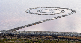
Great
Salt Lake spiral submerged
 During a
dry period in 1970, when artist Robert Smithson constructed a spiral earthwork
sculpture in Great Salt Lake in Utah, he discovered that the visibility of his
creation would be at the mercy of fluctuating water levels. “As an artist,
it is interesting to take on the persona of a geological agent and actually
become part of that process rather than overcome it,” the late Smithson
said in 1972, according to a Dia Art Foundation press release. But the elements
may momentarily triumph over Smithson’s sculpture, as rising water levels
threaten to obscure the famous piece known as Spiral Jetty.
During a
dry period in 1970, when artist Robert Smithson constructed a spiral earthwork
sculpture in Great Salt Lake in Utah, he discovered that the visibility of his
creation would be at the mercy of fluctuating water levels. “As an artist,
it is interesting to take on the persona of a geological agent and actually
become part of that process rather than overcome it,” the late Smithson
said in 1972, according to a Dia Art Foundation press release. But the elements
may momentarily triumph over Smithson’s sculpture, as rising water levels
threaten to obscure the famous piece known as Spiral Jetty.
The geologic sculpture Spiral Jetty
began to submerge in Great Salt Lake earlier this spring, as shown here on May
18. Image courtesy of Mark Milligan.
In 1970, Great Salt Lake was reported to have been 1.5 meters lower than the
historic average, at a height of only about 1,280 meters above sea level. Spectators
could easily walk along the 457-meter-long (1,500 feet) counterclockwise spiral
of indigenous black basalt, which measures about 5 meters wide. But water levels
soon rose and obscured the jetty, only to ebb once again in 1978.
For the last 36 years, weather cycles have dictated when Smithson’s sculpture
would make an appearance. “The jetty has a cyclical presence: being submerged
under water, reemerging encrusted in salt, weathering back to rock and then
being submerged again,” says Michael Govan, director and president of the
Dia Art Foundation. “Its recurring/disappearing act beneath the Salt Lake
only adds to its allure.”
And now, following a 1999 drought that allowed the jetty to reappear three years
ago (see Geotimes, January 2003), the spiral may
be going back into hiding. “The lake always fluctuates,” says Mark
Milligan, a geologist with the Utah Geological Survey. “This is one of
the greatest rises in lake levels of any spring for Great Salt Lake.”
Great Salt Lake’s levels depend mostly on two factors: precipitation and
temperature. And this year, Utah has seen more precipitation than most. A heavier-than-average
snow pack, for example, had Utah ski resort Snowbird remaining open until July
4, one to two months past its typical closure date for the season. “For
some areas in Utah, this is the wettest year on record,” Milligan says.
Kathryn Hansen
To read the full story, please visit the Geotimes
Web Extra posted online June 16.
"A Geophenomena special
exhibit," Geotimes, January 2003
Back to top
Untitled Document
