
|
 Subscribe

TRENDS & INNOVATIONS
Tracking Deadly Lahars
 Vernon Manville |
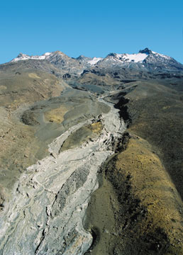
| Much of the Whangaehu valley was wiped out by a lahar that sprang from Mount Ruapehu Crater Lake in March 2007. This is about seven kilometers downstream from the lake. Peak discharge here was 1,900 to 2,300 cubic meters per second, as recorded by a sensor array on the island outcrop in the mid-ground. The light gray swath shows fresh lahar deposits. |
On March 18, 2007, the fragile natural dam that held in New Zealand’s Mount Ruapehu Crater Lake for more than a decade gave way. During the hour and a half following the collapse, more than a million cubic meters of hot, acidic water and mud cascaded down the steep flanks of the volcano, tearing up the ground and sweeping away everything in its path — boulders, rocks and huge amounts of sediment.
Such lahars — mudflows composed of rock debris and water that originate on the slopes of volcanoes and flow quickly down river valleys — are usually catastrophic. Throughout history, they have claimed tens of thousands of lives and caused severe structural damage around the world, from Nevado del Ruiz in Colombia, where a lahar buried 23,000 people in 1985, to Mount Pinatubo in the Philippines, where numerous lahars killed up to a few hundred people in 1991.
But the New Zealand lahar was different. Scientists knew that a lahar would happen at some point, so they set up a battery of equipment and monitoring stations to catch the mudflow in action. Meanwhile, the Department of Conservation, which manages Ruapehu as part of the Tongariro National Park, set up a warning system so that when the instruments indicated that a lahar was imminent, the government could evacuate people in time. As a result, no one was hurt. And the torrent of data the researchers collected now gives scientists a unique insight into how lahars form and develop. This, researchers say, will help them to revamp models to better predict lahars.
Lahars form in different ways: The walls of a crater lake sitting atop a volcano can break, as they did in New Zealand; a volcano’s snow- and ice-covered parts can melt during an eruption and send blankets of meltwater down the slopes, as happened in Colombia; or large amounts of rainfall on terrain covered with loose, volcanic material can spark a mudflow, as happened at Pinatubo. But it’s hard to know when any of these events are going to happen. This unpredictability is one of the things that makes lahars so dangerous, says Thomas Pierson of the U.S. Geological Survey Cascades Volcano Observatory in Vancouver, Wash. This unpredictability also explains why scientists had not collected much scientific data from lahars until last year.
 Vernon Manville |
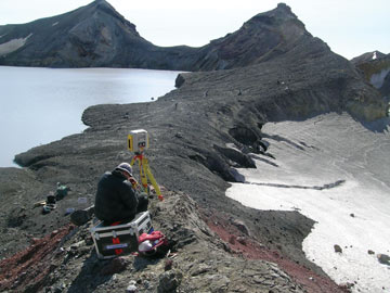
| New Zealand’s Mount Ruapehu Crater Lake was held in place for a decade by an earthen dam, which failed in March 2007. |
Before the event at Mount Ruapehu, lahar observations “had been pretty much ad hoc, rushing out to get a few bits of data,” says Vernon Manville, a senior scientist at the Institute of Geological and Nuclear Sciences in Taupo, New Zealand. The situation at Mount Ruapehu presented a once-in-a-lifetime opportunity.
A series of eruptions between 1995 and 1996 completely emptied the previous lake at the top of the volcano and piled up more than seven meters of sand and gravel across its natural outlet. Over the following decade, rain and snow filled the lake again, putting increasing pressure on the frail barrier. By 2006, the water reached a level that threatened to break through the dam.
“We knew that it would fail sooner or later,” says Shane Cronin of the Institute of Natural Resources at Massey University in New Zealand. That knowledge came from a grim precedent. A similar dam, created by an eruption in 1945, unexpectedly collapsed in 1953, sending a lahar thundering down the Whangaehu River, which flows down the volcano to the Tasman Sea. Along the way, the water tore down a bridge just as a train was about to cross it, killing 151 passengers.
 Shane Cronin |
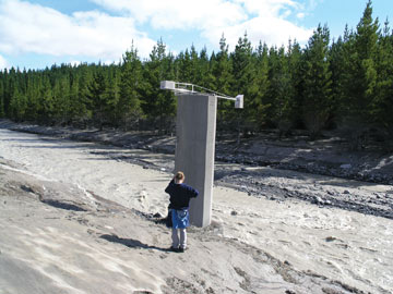
| Researchers installed a warning gauge (with a radar stage gauge mounted on top) along the railway line near Whangaehu River. They also installed a gas-bubbler stage gauge, acoustic flow monitor, broadband seismometer and a Web camera. |
This time, scientists and emergency personnel were prepared. Two years ago, a large team of lahar experts and researchers from scientific and government institutions in New Zealand and from overseas pooled their resources to set up monitoring equipment starting at the crater lake and extending 150 kilometers down the river valley. The exercise served two purposes, Cronin says. “We wanted to be able to warn people living in the downstream area to get out of the way in time, but we also wanted to capture as much scientific information as we could from this event so that we could plan for future lahars, which are much expected from this volcano.”
To monitor the dam’s stability, the team set up a camera next to the lake that took pictures once a minute. They laid a trip wire across the dam and positioned instruments inside the water to keep an eye on lake levels. A smattering of geophones scattered along the flanks of the volcano measured ground vibrations every few kilometers along the river valley. Seven kilometers downstream from the lake, the team set up the first major monitoring station, outfitted with a broadband seismometer, a radar gauge to measure the height of the flow and pressure sensors in the ground. More of these stations followed downstream. In addition, the team performed a LIDAR (light detection and ranging) survey to develop a 3-D map of the river channel’s topography.
On the morning of March 18, 2007, a small rainstorm finally sent lake water trickling over the trip wire. Soon after, the first vibration sensors triggered. The geologists immediately issued a warning. While everyone in harm’s way started to evacuate, about 20 members of the research team rushed to the site. As the lake emptied, the researchers watched the flow and sampled it at the various monitoring stations.
Across the first five kilometers, the lahar ripped more than 2.6 million cubic meters of sediment out of the ground, causing the lahar volume to reach more than three times its original size in only nine minutes, Cronin says.
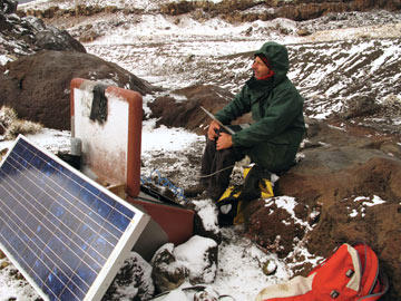 Vernon Manville |
| This time-lapse camera from Hokkaido University sits 54 kilometers from the crater lake on the afternoon the lahar struck (gray high-water marks are visible in the background). |
Five days later, the team did another LIDAR survey. Comparing the before and after maps, the team determined which locations saw the greatest erosion and which saw the greatest deposition. “Having been able to constrain these exact amounts means that we can now put them into hazard models,” Cronin says. “Until now that had been a matter of educated guess work.” That’s because scientists usually use data gathered from small artificial experiments, rather than from real-world events, says Michael Sheridan, a volcanologist at the University at Buffalo in New York and director of the school’s Center for Geohazard Studies. “The scale of the lahar at Mount Ruapehu was much larger than that of any experiments that had been used to calibrate and test models,” he says, adding that the team also managed to gather data that is tough to get from experiments. For example, because the lake water was more acidic than the river water, the researchers could calculate the mixing of the river’s freshwater with the lake water by measuring the pH of their samples. “That is something that would be very hard to replicate in an experiment,” Sheridan says.
And the better the models, the better the forecasts, Pierson says, not only at Mount Ruapehu but also in other places, such as Mount Rainier in Washington. “We want to learn and understand this process better so that in the future we can predict things like, ‘How big is this flow going to be, where is it going to go and how far is it going to go?’” But the data from Mount Ruapehu might also provide new clues about sediment records, he says, and help scientists interpret evidence that ancient lahars have left behind.
Lahars are one of the most hazardous types of natural phenomena and they are extremely complex to model, Sheridan says, adding that accurate data are vital for this process. “This is quite a unique dataset and it will be one of the best available for this type of event.”

