
|
NEWS NOTES | August 1999 |
Nighttime mysteries on Europa
A martian hunt on Earth
Predicting the South China Sea monsoon
A post-stishovite polymorph
Giant clams of the Triassic
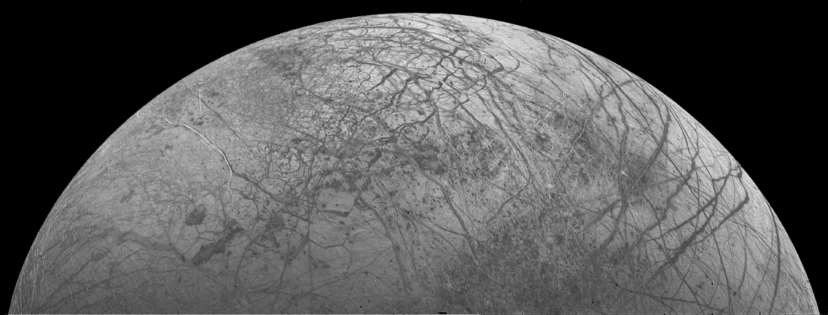
Voyager 2 image of Europa. Photo courtesy of Calvin J. Hamilton. NASA's Jet Propulsion Laboratory. |
Galileo observations continue to build an intriguing image of
Europa, one of Jupiters moons. Previous research generated much debate
about the moons age and ability to harbor life. One of the latest discoveries,
using information collected last year from Galileos photopolarimeter-
radiometer (PPR), revealed surprising |
nighttime temperatures on Europa. PPR created maps of the thermal radiation
of Europas nearly craterless surface, showing expected daytime temperatures
but anomalous nighttime temperatures.
John Spencer, an astronomer at Lowell Observatory in Flagstaff,
Ariz., and scientists from the Jet Propulsion Laboratory in Pasadena, Calif.,
and the Goddard Institute for Space Studies in New York, detail Europas
thermal emissions in the May 28 issue of Science.
The most interesting thing is the strange temperature
patterns that we see on the nightside of Europa and, particularly, the
strong correlation of temperature with latitude in the regions seen after
sunset, Spencer says.
Daily temperature fluctuations within the uppermost crust
(to a depth of about 4 cm) determine the surface temperatures for Europa,
an ice-covered satellite about the size of Earths moon. In addition, these
surface temperatures are related to surface composition and morphology.
Therefore, identifying Europas surface tempera-tures can produce a better
understanding of the processes that shape the surface, the scientists report.
Usually, darker surfaces respond to sunlight by increasing
in temperature during the day and releasing heat at night, resulting in
warm nighttime temperatures. Conversely, brighter surfaces absorb less
sunlight and release less heat at night, allowing for cool nighttime temperatures.
Globally, Europas light and dark regions do follow this
rule. On a smaller scale, however, some of Europas light surfaces emit
warmer temperatures at night than do the dark surfaces. For example, the
area with the highest nighttime temperature (95 K) includes the bright
ejecta blanket of the crater Pwyll.
The nighttime temperatures of the poles and the equator
are also curious. Northern latitude areas are warmer than corresponding
southern latitude areas, and equatorial regions are unusually cold at night.
Regions have increasingly lighter surface colors away from the relatively
darker equator, so the lighter northern and southern latitudes should have
cooler nighttime temperatures than the equator. However, the opposite is
true. For example, at longitude 55° W, the nighttime temperatures are
94.5 K at 30° N and 90.5 K at 30° S, near the poles, but are 88
K at 2° S, near the equator.
The scientists have no conclusive reasons for the temperature
differences, but they propose several explanations. It seems that brighter,
icier regions are warmer at night, which we might expect because large
crystals of ice may be better at storing nighttime heat than the brownish,
perhaps salt-rich, regions. But in many other places something else must
be going on, particularly, to produce the latitude-dependent post-sunset
temperatures, Spencer says.
The high nighttime temperatures around the Pwyll crater
might be explained by an abundance of rocks or regolith particles that
are roughly the same size as the sunlight penetration depth (about 4 cm
with a density of 0.5 g/cm3). Because the particles would increase the
amount of surface area available for heat flow, these rocks would increase
the amount of sunlight the crater regolith would absorb, thereby increasing
the nighttime temperatures. The ejecta may also absorb sunlight at depths
of 1 to 2 cm.
Galileos near-infrared mapping spectrometer found
large photon path lengths in high latitude ice. Larger path lengths result
from close contact of grains, which increases sunlight penetration and
temperatures. However, a similar theory could also be applied to low altitude
areas. In theory, high daytime temperatures will cause grain sintering
bond development through contact between solid grains. These sintered
grains will also increase the regoliths ability to absorb sunlight and
raise surface temperatures because greater contact between grains increases
conductivity, the scientists write.
Another theory is that tidal heating the internal frictional
heating of a satellite due to movement caused by the parent planets gravitational
pull may be responsible for the unusual nighttime temperatures. Researchers
predict that the internal heat generated by tidal heating is two to five
times greater in the polar regions than at the equator; this prediction
coincides with the observed warmer temperatures near the poles.
The lithospheric thickness of 0.34 km, which is within
the Galileo-based estimated thickness of the crust, is necessary to allow
enough endogenic heating to raise polar temperatures above temperatures
at the equator. However, the local heat flow required for the temperature
increase is beyond estimates of the current model for Europas mean tidal
heat flow. We dont consider an internal heat explanation to be very likely,
Spencer says.
The ridges and fractures that characterize Europas surface
suggest previous, and maybe present, geologic activity, but no conclusive
evidence for current activity exists. Nighttime temperature maps, however,
can be used to locate small areas warmed by internal heat. These hot spots
could remain decades after geologic activity stops. As yet, scientists
have not detected these areas.
If our alternative explanation for the nighttime anomalies
that they are due to heat leaking out of the interior is true, it would
imply a very warm, active interior and would increase the chances of an
ocean and of life, Spencer says. Most likely, however, the temperature
differences are due to the variability of heat storage on Europas surface,
such as the Pwyll ejecta blanket and surrounding areas. The implications
then will not be known until the scientists have a better understanding
of the anomalies.
The scientists would like to attach a thermal mapping
instrument on the future Europa orbiter for a higher resolution map. This
might reveal small, currently active regions where internal heat can be
detected at the surface
and should also tell us a lot more about what
is really controlling the nighttime temperatures, Spencer says.
Julia Cole
Geotimes Intern
Devra Wexler
Geotimes

First visible image of the Chinese geostationary weather satellite FY-11, showing strong convective activity over the South China Sea and vicinity during June 21, 1998. More information is available at <http://climate.gsfc.nasa. gov/~kim/relacs/campaign/scsmex.html>. Courtesy of National Satellite Meteorological Center/Chinese Mete- orological Administration, People's Republic of China. |
With new evidence linking the South China Sea monsoon to cyclone activity over the Indian Ocean, scientists are a step closer to forecasting the monsoons arrival each spring. Researchers from the South China Sea Monsoon Experiment (SCSMEX), an international scientific field campaign, presented recent study results at the American Geophysical Union (AGU) meeting in June. SCSMEX is a large-scale experiment to study the water and energy cycles of the Asian monsoon regions. A pilot study in 1996, which ended last year, included climatological data analysis, pilot station and mooring site set up, and the planning of Intensive Operational Periods (IOP) strategies. (IOPs are one-to-two-month periods of intense study.) During a field experiment phase between May 1 and July 31, 1998, scientists made hourly surface observations and dual Doppler radar observations, took aerosondes and |
PBL measurements, and made upper air soundings four times a day from stations on the South China Sea. The results of the field experiment, along with data analysis and modeling based on information already collected on rainfall estimates, moisture data, sea surface temperature, and other satellite data, led to the AGU presentations in Boston.
Radar and rainfall
According to William Lau, head of the Climate and Radiation Branch
of NASAs Goddard Space Flight Center and co-chief scientist for SCSMEX,
one of the most significant parts of the observational platforms is an
intensive flux array, consisting of a dual Doppler radar pair for detailed
rainfall measurements over the South China Sea. This array, along with
land and shipboard radar and rainfall measurements from the Tropical Rainfall
Mapping Mission (TRMM) satellite, provides information on cloud and rain
patterns. Detailed analysis of the data helps the researchers pinpoint
the start of the summer monsoon.
The South China Sea region experiences a winter monsoon
and a summer monsoon. During the winter, cold, dry air flows into the region
from the Arctic. But the flow reverses in the spring, and starts bringing
warm, wet air from the south. This transition always takes place at a different
time, and the SCSMEX scientists are aiming to time the monsoons first
appearance. Data gathered during last years field phase significantly
improved their knowledge of the start dates. For example, they determined
that the 1998 summer monsoon settled in over the northern part of the South
China Sea on May 15, and over the southern part of the sea on May 20. But
is there a way to predict the monsoons onset? The researchers hope so.
Clues from cyclones
About 10 years ago, scientists recognized a phenomenon of massive twin
cyclones that appeared every spring over the equator. The cyclones, each
twice the size of Texas, travel eastward, straddling the equator. They
then split up, and the southern cyclone dies out. The northern cyclone
moves north from the equator and turns into a monsoon over the Bay of Bengal.
It turns out that this happens only a few days before the onset of the
South China Sea monsoon. According to Lau, the 1998 SCSMEX operations marked
the first time the cyclone system could be linked to the start of the Asian
monsoon season.
Lau plans to watch the twin cyclone system unfold this
year to try and understand how its strength and timing can help forecast
the monsoon and perhaps predict flooding in southern China.
The monsoon and flooding
Weather changes in the region seem to be linked to the South China
Sea monsoons. Lau reports that he and his colleagues found a connection
between the disastrous 1998 Yangtze River flood and the timing and strength
of the summer monsoon. In 1998, the South China Sea monsoon came late
and with less than its usual punch, a possible warning of the intense rains
over South China and the deadly floods that followed, Lau says.
Analysis of SSM/I (Special Sensor Microwave/Imager) wind
and moisture data suggested that the delayed convective activity over the
South China Sea may be linked to the weakened northward propagation of
[the] monsoon rain band, hence contributing to a persistence of the rain
band south of the Yangtze River and [to] the disastrous flood that occurred
over this region during mid to late June 1998, Lau reported at AGU.
If the monsoon can be predicted, perhaps such effects
can be forecasted as well. Clues to the cause, timing, and evolution of
the summer monsoon, and a better understanding of how it can vary, will
help flood planners, water managers, and farmers reduce losses of life,
livestock, agriculture, and property. Data analysis and interpretation
and the modeling component of SCSMEX, along with satellite measurements,
will continue through 2002.
Devra Wexler
Geotimes
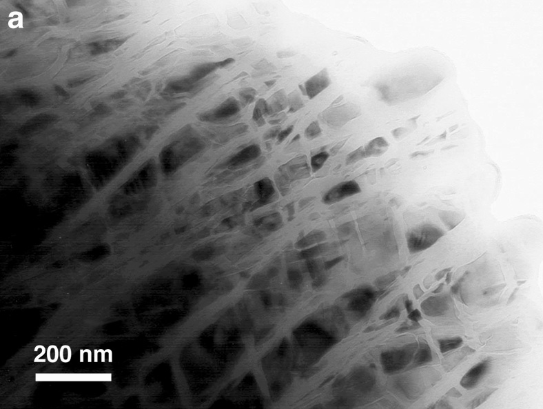
A new, post-stishovite, SiO2 polymorph.
Thomas
|
A mineral can only take so much pressure. Increasing the stress on
a mineral will either shatter or distort it or cause its crystal structure
to adapt by compressing into a new, denser polymorph.
In the three low pressure polymorphs of SiO2 (quartz, tridymite, and cristobalite), the silicon atoms are bonded, or coordinated, with four surrounding oxygen atoms in a tetrahedral structure. The same tetrahedral coordination also exists in one SiO2 high-pressure polymorph (coesite). However, at higher pressures, the silicon is forced to bond with six oxygen atoms into the denser polymorph known as stishovite. |
Joshua A. Chamot
Department of Geology,
University of Tennessee, Knoxville
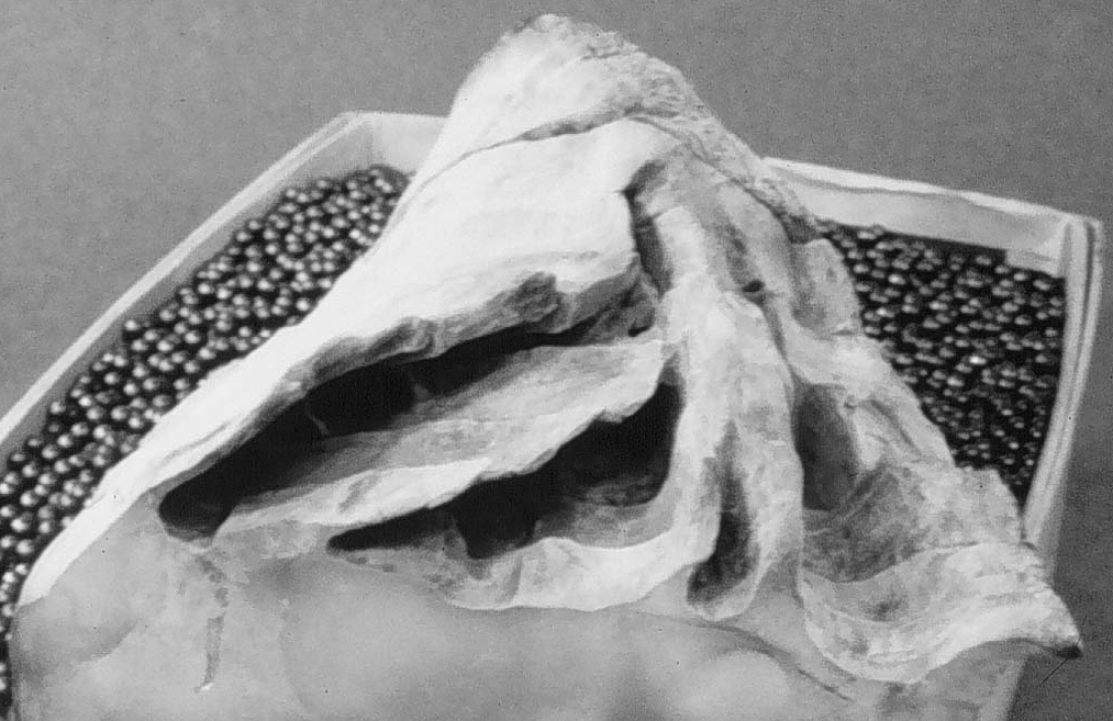
Wallowaconchidae. Courtesy of Korla McAlpine, University of Montana. |
The discovery of a new family and species of giant clams revealed
information about Triassic clams and the Triassic Pacific. George Stanley,
a University of Montana (UM) geology professor, and Thomas Yancey, a researcher
from Texas A&M University, described the giant clams, which range
up to 3 feet in diameter, in the February 1999 issue of Paleontology.
In the mid-1980s, Stanley and a student discovered the saucer-shaped |
fossils, silhouetted in white in a wall of black limestone, in a quarry
of the Wallowa Mountains in Oregon. Unable at the time to separate the
fossils from the limestone, they transported the limestone, more than 400
pounds of rock, to UM. The similar densities of the fossils and their matrix
rendered X-rays ineffective. The fossils identities remained a mystery
until two years ago, when Yancey, having the tools and the time, began
removing the surrounding rock, and could see the internal morphologies
of the giant clams. The researchers assigned the fossils the family name
Wallowaconchidae,
after the surrounding mountains.
The fossils had unusual wing-like extensions surrounding
their central body cavities. According to the scientists, the clams
used chambers inside their shell extensions to nurture and house algae.
Partially translucent shells or natural fiber optics allowed light to pass
through the clams shells to the symbiotic algae.
The extinct clams lived in the Triassic period about 200
million years ago. The researchers believe that the clams habitat was
a shallow lagoon, behind coral reefs, that surrounded isolated volcanic
islands like Tahiti or Fiji located in the eastern Pacific. Identical fossils
were found in the Yukon and in Sonora, Mexico.
The different locations of the fossils may help geologists
reconstruct the paleogeography of the Pacific during the Triassic. I believe
the clams were living in isolation around an island like the Galapagos
and eventually plate tectonics brought them crashing into North America.
Later fault systems moved them north and south, Stanley says.
Julia Cole
Geotimes Intern
 |
Geotimes Home | AGI Home | Information Services | Geoscience Education | Public Policy | Programs | Publications | Careers |