geotimesheader  
Geotimes Home Calendar Classifieds Subscribe Advertise
Geotimes
 Published by the American Geological Institute
December 2000
Newsmagazine of the Earth Sciences

News Notes


Paleoseismology
Mysteries in the Bay of Aboukir
 
 About 1,700 years ago an earthquake struck a region in the Mediterranean Sea, creating a tsunami that wiped out the Eastern Port of Alexandria in Egypt and Cleopatra’s Royal Quarters. After finally discovering the flooded treasure room in 1996, scientists turned their attention to other lost pharaonic cities further east in the Bay of Aboukir.

The scientists announced discovering the cities this summer, but it remains a mystery how Canopus, Menuthis and Herakleion, cities 25 kilometers east of Cleopatra’s sunken royal quarters, also fell prey to a watery demise. At the fall meeting of the American Geophysical Union in San Francisco this month, researchers will be scrutinizing earthquakes as possible culprits.
 
But, “we have a problem,” says geophysicist Amos Nur of Stanford University. Nur and his colleagues know the ground under the cities subsided by about 5 meters — damage that a magnitude-8.2 earthquake on a nearby fault could deliver. Only, “we don’t know if such a fault existed in early Alexandria,” he says. This leaves the possibilities for destruction and the geological significance of the area wide open, he says.
 
Nur is part of an international team of geologists, historians and specialized divers who have been working under the leadership of French archeologist Franck Goddio to uncover the cities. Using clues from ancient texts and past discoveries, they surveyed the Bay of Aboukir with depth sounders, nuclear resonance magnetometers, side-scan sonar and a sub-bottom profiler. The team found the eastern suburb of Canopus, its neighboring city Menuthis and the entire missing city dedicated to Hercules, Herakleion, under 6 to 8 meters of water.

 
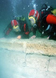
 Divers Gregory Dalex and Philippe Rousseau 
 examine the foundations of a wall after excavation.
 All of the vestiges were buried beneath the sediment.
 Christoph Gerigk for Hilti Foundation/Discovery Channel/
 Frack Goddio
 
Alexandria fishermen have long been tormented by what was discovered to be the closer coastal city of Menuthis — whose protruding structures catch the fishing nets, Nur says. Under 5 to 6 meters of water, much of Menuthis and Herakleion still lie protected beneath the sediment.
 
The cities share a peculiar trait besides sitting on subsided land. “Columns and free-standing objects fell west-northwest,” Nur says, indicating structural collapse that may or may not be related to the subsidence.
 
Built on the marshland of the Nile delta, the cities may have been damaged after an earthquake turned their porous silt foundation into liquified mud. But Nur doubts liquefaction was the cause. Instead, he says, an earthquake or an underwater landslide may have induced the large-scale slumping.
 
The Izmit earthquake of magnitude 7.4 caused similar destruction to the city of Gölcük, Turkey, on Aug. 17, 1999. “The ground moved laterally and subsided,” says William Lettis, president of William Lettis and Associates, an earth science consulting firm in Walnut Creek, Calif. Some buildings in the earthquake collapsed but many remained intact as they sank beneath the Marmara Sea, he says.
 
“Wherever a Holocene delta was built out into the water along a fault rupture, we saw evidence of minor to catastrophic coastal subsidence,” Lettis says. The Nile River delta is also composed of recent Holocene material and, despite a lack of evidence for a nearby fault, earthquakes are a known historical hazard.
 
Documentation of earthquake damage in Alexandria dates back to A.D. 365, when a tsunami wiped out the Eastern Port of Alexandria and the queen’s cache. Ancient writings tell of the harbor emptying out to sea, says Daniel Stanley, a coastal geologist at the Smithsonian Institution and a member of the discovery team. The people in town walked out onto the new beach to collect fish, not realizing the water would return in the form of a giant, devastating wave.
 
The epicenter of the quake that caused the tsunami is still uncertain. Stanley, who will give a presentation at the AGU meeting, believes the earthquake formed on the opposite seashore, closer to Turkey or Crete, with the wave traveling 800 kilometers across the Mediterranean. He questions the idea that such an earthquake caused the subsidence of the ancient cities in the Bay of Aboukir.
 
Gold Islamic and Byzantine coins found in the bay point to the legendary cities surviving past the seventh and into the eighth century. Using the Egyptian and Arabic measurements of the height of the Nile River, Stanley zeroed in on A.D. 741-742 as a time of flooding when “something failed.”
 
Although he has not dismissed an earthquake as the cause, he argues that the Canopic branch of the Nile River was switching back and forth during that time. Flooding in the delta could have just as easily caused the slumping failure of the land with the sediments becoming heavily water-laden and physically unstable, he says. “They really didn’t have much of a foundation. It was an accident waiting to happen.”

Christina Reed


Geotimes Home | AGI Home | Information Services | Geoscience Education | Public Policy | Programs | Publications | Careers

© 2024 American Geological Institute. All rights reserved. Any copying, redistribution or retransmission of any of the contents of this service without the express written consent of the American Geological Institute is expressly prohibited. For all electronic copyright requests, visit: http://www.copyright.com/ccc/do/showConfigurator?WT.mc_id=PubLink