
 For
hundreds of years, Mars has fascinated everyone from authors and artists to
astronomers and geologists. Many researchers have mapped the region based on
space mission data and observation, but unanswered questions reamin, most notably:
Was the Red Planet hydrologically active and what does that mean for life on
Mars? These are the kinds of questions a new study on ancient martian geology
begins to answer.
For
hundreds of years, Mars has fascinated everyone from authors and artists to
astronomers and geologists. Many researchers have mapped the region based on
space mission data and observation, but unanswered questions reamin, most notably:
Was the Red Planet hydrologically active and what does that mean for life on
Mars? These are the kinds of questions a new study on ancient martian geology
begins to answer. In this months Journal of Geophysical Research, University of Arizona hydrologist James Dohm and his colleagues report that an enormous ancient drainage basin and aquifer system lies hidden and deformed in Mars geologically dynamic landscape.
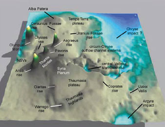
[3-D portrayal of the major geologic features of the Tharsis Magmatic Complex at Stage 5 in the Amazonian period using Mars Orbiter Laser Altimeter data. Courtesy of J.M. Dohm and K.L. Tanaka.]
They estimate that for billions of years, the basin, the size of the United States, interacted with Tharsis a magmatically active bulge in the western equatorial region. Dohm says the Tharsis complex includes lava flow fields, towering volcanoes, flood channels, igneous plateaus and vast canyon systems.
The 10-year study is a synthesis of geologic information from all published maps stemming back from the Mariner-based geologic investigations of the 1970s as well as the Viking-based investigations, Dohm says. The group also used the recent high-resolution topographic data from the Mars Orbiter Laser Altimeter and the Mars Global Surveyor spacecraft.
Using these data, the research team took a trip back through time to create what they call an illustrated working hypothesis. Their 3-D animated visualization portrays how the Tharsis region landscape evolved over more than 3 billion years.
The ancient basin is an estimated 45 million cubic kilometers with a depth ranging from 2 to 7 kilometers. With an average depth of 5 kilometers, it would have a capacity of 12 billion-billion gallons. As lavas and sediments filled the basin early in Mars history, the basin became a vast aquifer. If these fill materials are as porous as sediments and lavas on Earth, the researchers say, the potential volume of the aquifer would more than equal the volume required to create an ocean in the martian northern plains.
Over time, meteorite impacts and the relentless magmatic-driven tectonism in the Tharsis region created fractures in the aquifer system. The groundwater was then able to move through these fractures. The resulting fractures would act like a highway system for the water, allowing it to flow faster than groundwater typically does as it moves through sediment or rock, says Justin Ferris, co-author and a University of Arizona hydrologist.
Dohm says that the basin system is perhaps most significant in that it provided a source for large outflow channels near the Tharsis region. These huge valley systems, as wide as 200 kilometers, could be the largest flood channels discovered in the solar system.
Dohm and his colleagues think that the layered walls of the Valles Marineris a huge canyon system at the center of the proposed basin represent infilled flood lavas, and erosional lake and wind deposits. Magmatic and tectonic energy drove sediment-charged flood waters toward the northern plains to form putative oceans, or large lakes, and possibly ice at the poles.
Co-author Victor Baker had previously proposed the MEGAOUTFLO hypothesis to explain how pulses of magmatic activity formed these water bodies, as well as planetary glaciation and other hydrological and climatological events on Mars. The basin hypothesis further supports his findings and the idea that Mars northern plains once featured at least two oceans.
The study has also given researchers a better feel for what Mars looks like today. Dohm says evidence shows that Mars may still be active. The unmodified parts of the aquifer may still contain near-surface reservoirs that astronauts could sample and analyze, Dohm says. And we see recent magmatic-driven tectonic and fluvial activity in the basin and surrounding regions, including grabens, chains of pit craters, and fault-sourcing valleys and fluidized flows marked by very few, if any, impact craters. He emphasizes that where there is magma interacting with ground ice or groundwater, there is hydrothermal activity.
There is a suite of information indicating that Mars is a potentially water rich planet, with a rich geologic history. And over time we get more and more information so it strengthens our understanding of Mars, and where we should go, Dohm says. Ultimately, Dohm wants to be able to sample candidate sites to learn more about the planets past geology, climate, hydrology and even potential biology. He sees the research as providing a possible blueprint for future exploration, and maybe even for colonizing the planet someday.
