
Geotimes Home | AGI Home | Information Services | Geoscience Education | Public Policy | Programs | Publications | Careers

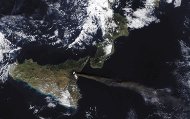 What began
as a swarm of minor earthquakes and a series of erupting fissures in the predawn
hours of Oct. 27, became an unusual display of activity from Italy’s Mount
Etna that continued into mid-November. Two days after the eruption began, a magnitude-4.4
earthquake left thousands homeless in the town of Santa Venerina on the volcano’s
southeast flank. That same week, lava flows from the Northeast Rift slowly cut
across the road connecting the towns of Linguaglossa and Piano Provenzana, devastating
a hotel complex and igniting several forest fires along the way.
What began
as a swarm of minor earthquakes and a series of erupting fissures in the predawn
hours of Oct. 27, became an unusual display of activity from Italy’s Mount
Etna that continued into mid-November. Two days after the eruption began, a magnitude-4.4
earthquake left thousands homeless in the town of Santa Venerina on the volcano’s
southeast flank. That same week, lava flows from the Northeast Rift slowly cut
across the road connecting the towns of Linguaglossa and Piano Provenzana, devastating
a hotel complex and igniting several forest fires along the way. 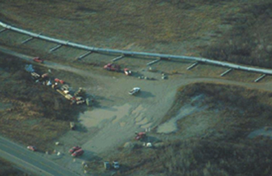 In
fewer than two weeks, two major earthquakes on the Denali Fault rattled central
Alaska. Seismologists across the nation have mobilized to determine the effects
of the magnitude-6.7 and magnitude-7.9 quakes that hit on Oct. 23 and Nov. 3 respectively,
about 200 miles to the northeast of Anchorage. They were the biggest earthquakes
felt in the area since 1932, and probably not the last.
In
fewer than two weeks, two major earthquakes on the Denali Fault rattled central
Alaska. Seismologists across the nation have mobilized to determine the effects
of the magnitude-6.7 and magnitude-7.9 quakes that hit on Oct. 23 and Nov. 3 respectively,
about 200 miles to the northeast of Anchorage. They were the biggest earthquakes
felt in the area since 1932, and probably not the last. |
Geotimes Home | AGI Home | Information Services | Geoscience Education | Public Policy | Programs | Publications | Careers |