
 Although
geoscientists have found no obvious natural law that dictates how often and
by what means a river should flood, researchers studying floodplains in northern
Bolivia expected to find thin, regular, datable layers. But when they examined
sediment cores from the pristine systems in the Amazon basin, they realized
most of those layers were missing — years of layers, actually. And the
sediment layers that were there were very thick. The sediment transport system
was completely different from what they had hypothesized.
Although
geoscientists have found no obvious natural law that dictates how often and
by what means a river should flood, researchers studying floodplains in northern
Bolivia expected to find thin, regular, datable layers. But when they examined
sediment cores from the pristine systems in the Amazon basin, they realized
most of those layers were missing — years of layers, actually. And the
sediment layers that were there were very thick. The sediment transport system
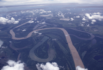
was completely different from what they had hypothesized. The Mamoré River winds through the Bolivian Andes before reaching a vast foreland basin where the floodplain is expansive. Courtesy of Rolf Aalto.
“It was a bit sobering,” says Rolf Aalto, a geologist with the University of Washington and lead researcher on the project, “because, at first, nothing made sense.”
The Beni and Mamoré river basins comprise 720,000 square kilometers of the Amazon basin. The Beni drains 70,000 square kilometers of the Bolivian Andes and an additional 50,000 square kilometers of densely forested, isolated and pristine floodplain. The Mamoré drains 600,000 square kilometers of the mountains and the foreland basin, both of which are largely unchanged by people.
As reported in the Oct. 2 Nature, Aalto’s international team collected 276 cores, 65 to 160 centimeters deep, at transect distances of 50 to 3,000 meters from the channels, predominantly from the higher, more mature floodplains. In studying the lead-210 isotopic activity profiles of a subset of cores, they developed a flexible new methodology for floodplain geochronology. The geologists found that the sediment stratigraphy is dominated by 20- to 80-centimeter thick discrete sediment packages. They eventually started seeing similar signals in cores across the floodplains, Aalto says. The isotopic profiles suggested system-wide recurrence intervals of eight years, with complete voids in time between each thick sediment layer.
That the stratigraphic record is missing substantial chunks of time is not a new idea, says Chris Paola, a geologist at the University of Minnesota, who wrote an accompanying comment in Nature. “It’s as if you remembered only one year of each decade, and of that year, only one of every 10 days, and so on. The stop-and-go nature of sedimentation leads to pervasive discontinuity. But no one knows why.”
To solve this temporal mystery, Aalto’s team turned to ocean temperature and stream flow records. They linked the floodplain depositional layers to rapidly rising floods that occur during La Niña events in Bolivia. Rather than corresponding to annual flooding events in the rainforests, each large sediment influx corresponded to a La Niña event in the historic record, according to the research, funded by the National Science Foundation and NASA.
La Niña — the cold phase of the El Niño/Southern Oscillation cycle (ENSO) — drops excessive amounts of rain on the Andes roughly every eight years. When those heavy rains hit, they trigger great floods that wash vast amounts of sediment out of the mountains and into a huge foreland basin.
