
 Many scientists
consider Jackson Hole, Wyo., and the surrounding area overdue for a magnitude-7.0
earthquake on the Teton fault. Underlying Jackson Lake Dam and much of Jackson
Hole, the Teton fault has been seismically quiet for many years, but an earthquake
could happen at any time. Now after years of hard work, the people of Wyoming
have a new seismic network in a seismic “gap” of the West. This data
will prove essential to planning and preparation in the community.
Many scientists
consider Jackson Hole, Wyo., and the surrounding area overdue for a magnitude-7.0
earthquake on the Teton fault. Underlying Jackson Lake Dam and much of Jackson
Hole, the Teton fault has been seismically quiet for many years, but an earthquake
could happen at any time. Now after years of hard work, the people of Wyoming
have a new seismic network in a seismic “gap” of the West. This data
will prove essential to planning and preparation in the community.
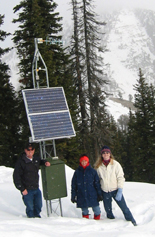
Jason Rolfe, a local geologist, and Lyn
Shaunesey and Candice Cotton, staff of Sen. Michael Enzi (R), climbed to the
Teton Pass site of the Teton Seismic Array in Jackson Hole, Wyo. — a project
with both grassroots and congressional support.
Our story in Wyoming is one of many in which a group of local citizens successfully
promoted the use of science for the good of the public. It is both a cautionary
story of what can go wrong when residents do not pay attention, and a story
of hope and determination, showing what an informed public can accomplish.
The story of the Jackson Hole seismic network begins in 1908, when after years
of surveying and construction, the Jackson Lake Dam in Wyoming was completed,
bringing much needed water to Idaho farms. The construction of the original
dam, which was considered temporary, was a monumental undertaking with 100-mile
mule trains, opening of new coal mines, and building of towns to support the
effort. Yet, only two years after completion, the center portion of the dam
failed, releasing 194,000 acre-feet of water into the swollen Snake River.
A new dam was completed in 1911. Although the level was raised 18 feet, more
water storage for Idaho farms was necessary. Thus in 1913, an enlargement program
began that ultimately raised the dam an additional 35 feet, building the dam’s
capacity to 790,000 acre-feet. Dredging in the 1920s further enlarged the reservoir.
Yet five decades later, in the late 1970s, geologists raised concerns about
the stability of the dam. It was constructed on gravels and muds deposited by
the Snake River and glaciation. Liquefaction of the underlying sediments during
a seismic event might cause the structure’s failure, causing a much larger
disaster than the failure in 1910.
In the 1980s, plans to replace the dam were devised, including a microseismic
network installed by U.S. Geological Survey (USGS) engineers and operated by
the Bureau of Reclamation to determine the angle of the Teton Fault. However,
by 1990, water users were objecting to paying for the network’s operating
costs. The Bureau of Reclamation responded by closing the seismic network.
Meanwhile, our small group had originally met in the early 1980s to “talk
rocks.” Paul Walton, J. David Love, Jane Love, Keith Watts, Jim Barlow,
Joe Bennett and I soon realized that much of what we talked about would be helpful
to our neighbors as the town of Jackson grew. We decided to engage the public
when we had solutions. Our group took a position in 1991 that the network should
remain for both public safety and the goal of determining the angle of fault.
We communicated with our senior U.S. senator, Alan K. Simpson (R), and for several
years, funding was maintained through congressional action. We built partnerships
with the public and elected officials in the region, which grew to include state
and federal officials, including then-Wyoming State Geologist Lance Cook.
Still, the Bureau of Reclamation, determined to eliminate the seismic network,
announced that even though some 18,000 events had been recorded near the Teton
Fault, no events had been recorded on the Teton Fault itself. Subsequently,
in an internal memo, one official declared the angle of the fault based on seismologists’
models, and turned off the network. That left the area without seismic monitoring
coverage.
The loss became even more apparent when terrorists attacked New York and Washington,
D.C. — all information on dam’s safety became cloaked in secrecy.
Without notice and while in negotiations to take over the network, the Bureau
of Reclamation’s head of dam safety had the monitoring equipment removed.
We were astounded by the act, but we responded through our enormous partnership.
The local press not only covered this story, but also determined that the automatic
early-warning system that the bureau claimed to be in place for public safety
did not actually exist. The need for sound science was clear, and Wyoming’s
governor and the entire congressional delegation joined the effort.
When Sen. Michael Enzi (R) asked if we could support funding a new smaller network
operated by the USGS, we jumped at the chance. Likewise, Rep. Barbara Cubin
(R) and Sen. Craig Thomas (R) also supported the effort to enable seismic monitoring
of Jackson Lake Dam. These efforts, including many trips to Washington, finally
paid off with congressional funding in the summer of 2003.
USGS immediately installed the first site at Red Top Meadow just south of Jackson
Hole. Throughout the winter, USGS designed the network and began deploying the
rest of the stations. Now, we must install the newly created USGS software that
will automatically warn the local emergency managers of seismic events and send
them ShakeMaps for emergency unit dispersal.
The network is one of several that are part of the USGS Advanced National Seismic
System, a program authorized for $30 million each year from 2002 to 2006, but
still only appropriated at around 10 percent. Perhaps grassroots movements such
as the one we headed in Jackson Hole, will help push the program ahead even
further.
 |
Geotimes Home | AGI Home | Information Services | Geoscience Education | Public Policy | Programs | Publications | Careers |