
 As Hurricane
Stan moved across Central America in early October, the storm brought torrential
rainfall into an already saturated region. Ultimately, the storm triggered landslides
of all sizes across the country, which had only recently recovered from the
effects of Hurricane Mitch, seven years ago.
As Hurricane
Stan moved across Central America in early October, the storm brought torrential
rainfall into an already saturated region. Ultimately, the storm triggered landslides
of all sizes across the country, which had only recently recovered from the
effects of Hurricane Mitch, seven years ago.
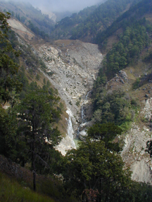
Heavy rains during hurricanes and tropical storms trigger devastating debris
flows and landslides in Guatemala, such as this one shown in 2000, two years
after Hurricane Mitch hit. This year, Hurricane Stan buried villages in mudslides
and sent smaller debris flows coursing down rivers into settlements. Courtesy
of Bob Bucknam, USGS.
One of the most horrifying accounts came from a small Mayan village on the flanks
of Volcano Atitlán, on the shores of a lake of the same name. A slurry
of fluid mud buried Panabaj on Oct. 5. More than 500 people were killed —
most likely buried alive — trapped in their houses or unable to outrun
the flow. (Debris flows can move at speeds of 50 kilometers per hour, or 30
to 35 miles per hour.) A week after the landslide, the remaining residents of
the village decided to turn it into a memorial, according to The New York
Times.
Such debris flows are lethal, says Anthony Crone of the U.S. Geological Survey
(USGS), who worked in the region after Hurricane Mitch, “and once they
stop flowing, they set up like concrete.” Carrying large blocks of rock
and tremendous amounts of debris, “they flow very quickly and [over] long
distances,” with “a lot of power.”
In addition to the mudflow that buried Panabaj, many small landslides occurred
to the north and northeast of Lake Atitlán, Crone says from his examination
of high-resolution satellite images of Volcano Atitlán and its flanks,
taken within days of the landslides. These debris flows appeared to be less
dense and less fluid than mudslides, though Crone says such labels are speculative
until geologists can get on the ground. Geologists from USGS have not yet visited
the sites, as they generally must be invited by a local government and sponsored
by the U.S. Agency for International Development or other relief organizations.
Crone compares the area surrounding the volcano’s flanks to a dangerous
layer cake of loosely packed volcanic sands, topped by soils that develop into
impermeable clay layers covered in vegetation. As more volcanic episodes occur,
they top the clay soils with loose volcanic sand again, and the buried clay
soils act as a barrier to water percolating down through those upper layers.
During storms, the water gathers in a pond trapped above the clay soil.
Thus, when Hurricane Stan hit, the already wet steep hillslides may have been
primed to fail, Crone says: The trapped water probably lubricated the volcanic
deposits perched on the hillslopes. He describes the areas that failed as very
steep, with highly eroded river valleys that channeled some of the landslides.
In many of the region’s small towns and villages, people tend to build
in the potential path of landslides, says Manolo Barrillas, currently a graduate
student at the Colorado School of Mines in Golden, Colo., who has worked in
the area. “Most of the people are very poor,” Barillas says, and live
without water infrastructure or land-use planning. “Many of those people
live in a very high risk area.”
According to CONRED, Guatemala’s disaster management division, the two
largest mudflows killed almost 1,000 people between them (hundreds of people
were reportedly still missing, weeks later). Smaller mudflows also occurred
around western and central Guatemala, bordering Mexico, Barillas says.
Several years ago, after Hurricane Mitch, “abnormally heavy rains, possibly
associated with El Niño and La Niña, caused a big mudflow,”
Barillas says, so at least some people living on Atitlán’s flanks
were probably aware of landslide risks in addition to volcanic risks. Still,
some mayors claimed that they did not receive evacuation alerts for this storm,
he says.
Towns and farms, in a region where volcanic soils are perfect for coffee and
other crops, are sometimes far enough apart that communication about past hazards
can be difficult, says Janelle Haapala, a graduate student at Michigan Tech
and lead author of a USGS landslide hazards map for Guatemala, to be released
early next year. So far, says Jim Vallance of the USGS Cascades Volcano Observatory,
a co-author of the map, the slope failures that occurred after Hurricane Stan
seem to have substantiated their findings.
Hurricane Mitch affected the eastern part of Guatemala in 1998, devastating
parts of Honduras, Nicaragua and El Salvador as well, whereas Hurricane Stan
hit the Yucatan Peninsula directly and then traveled into western Guatemala.
Soon after, the last tropical storms of this season, Alpha and Beta, caused
widespread flooding in Honduras and Nicaragua, but no landslides were reported.
Naomi Lubick
For initial coverage of the Kashmir earthquake,
visit the Geotimes Web Extra archive.
 |
Geotimes Home | AGI Home | Information Services | Geoscience Education | Public Policy | Programs | Publications | Careers |