
|
|
|
HELP for water resources
Although oceans cover almost three-fourths of the planet, Earths supply of freshwater amounts to only 3 percent of the total water on the globe. Given the growing human population, Earths liquid resources could soon be stretched to the limit. Whats needed now is to use advances in satellite and remote-sensing technologies to manage water resources more effectively. Such is the message from HELP, Hydrology for Environment, Life and Policy, a research initiative recently started by UNESCO (United Nations Education, Scientific and Cultural Organization). Through this global initiative, we can start to make that linkage between the needs on one hand and the expertise on the other hand, says Jim Shuttleworth, a University of Arizona professor of hydrology and task force member of HELP.
Inspired by recent international conferences and
research on freshwater issues, a multidisciplinary group of about 50 international
water experts met in Tucson, Ariz., last November to define how HELP will
be carried out. The initiative must spur a paradigm shift in hydrology
and water management to connect the science with current societal needs
and issues, says Mike Bonell, chief coordinator of UNESCOs International
Hydrological Program, oversees HELP. In this sense, the real challenge
is fostering cooperation and communication among the fields of hydrology,
water management and public policy.
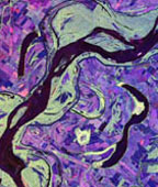
This radar image of the Mississippi River is similar to other images that will be used to choose drainage basins to monitor as part of the international HELP initiative for water management. Image from NASA's Jet Propulsion Laboratory. |
One of the goals of the HELP initiative
is to mitigate impacts of future global climate changes. For instance,
the next time Peru and Central America experience flooding and Southeast
Asia suffers drought related to an El Niño, HELP supporters hope
that these countries will have sufficient advance warning and knowledge
to prepare. Therefore, the first item on HELPs agenda is developing a
global network of drainage basins for long-term monitoring. This network
would allow water managers to vastly increase their knowledge of water
resources and share their data. Currently, hydrological forecasting relies
heavily on local data collection, but scientists now agree that regional
conditions are affected by worldwide weather patterns, and a global perspective
of water resources is in short order. During the next year, HELP researchers
will focus on selecting drainage basins for the monitoring networkup to
100 to 200 areas.
After drainage basins are selected, new techniques for remote data collecting, satellite measurements and modeling will need to be combined with traditional field research and ground-truthing to provide the most complete information on the chosen basins. Bonell estimates that the first five years of HELP will be a warm-up period experimenting with finding the best mix of methods. |
The United Kingdom and Japan have already begun selecting drainage basins for long-term monitoring. In the United States, NOAA, NASA, the U.S. Geological Survey and the National Science Foundation have shown support for HELP. Internationally, the next step is to present the HELP science and implementation plan drafted at the Tucson meeting, invite participation and gather formal approval from the 60 nations attending the Second World Water Forum March 1722 in The Hague.