geotimesheader
News Notes
Tectonics
Perfecting
Pangaea
Debate over the proper alignment of the continents that formed the supercontinent
Pangaea has put paleontologists and structural geologists at odds with
geophysicists who study paleomagnetism. Many may be unaware that the discord
exists, but those in tune know that there is an alternate model for Pangaea
that is not commonly printed in textbooks and is often ignored by most
geologists. How can seemingly valid data sets point to such different positioning
of the continents? Some scientists believe that the answer lies in a re-evaluation
of Earths paleomagnetic record.
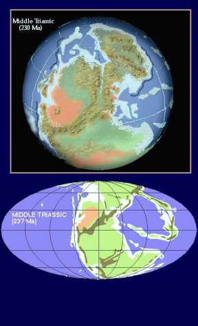 Any introductory
geology textbook offers an illustration of Pangaea Pangaea-A to be exact.
This model of the arrangement of Earths continental landmass during the
Triassic is mapped according to corresponding sedimentary layers, mountain
chains and fossil beds of Africa and the Americas. The lesser-known model,
Pangaea-B, follows paleomagnetic data and places South America and Africa
further north along the east coast of North America than Pange- A.
Any introductory
geology textbook offers an illustration of Pangaea Pangaea-A to be exact.
This model of the arrangement of Earths continental landmass during the
Triassic is mapped according to corresponding sedimentary layers, mountain
chains and fossil beds of Africa and the Americas. The lesser-known model,
Pangaea-B, follows paleomagnetic data and places South America and Africa
further north along the east coast of North America than Pange- A.
[At right: Reconstruction of the supercontinent
Pangaea during the Triassic (230 Mya). Ron Blakey, Northern Arizona University]
The paleomagnetic model of Pangaea is not accepted by geologists,
says Rob Van der Voo of the University of Michigan. Van der Voo and his
colleague, Trond Torsvik of the Geological Survey of Norway, led a team
that has been investigating Earths past polarity in search of the key
that will make the two models fit into one. They presented their work on
Dec. 19 at the fall meeting of the American Geophysical Union.
Scientists who study paleomagnetism have often assumed that Earths
ancient magnetic field always took the form of a simple dipole magnet.
Today, scientists know that about 20 percent of Earths present-day magnetic
field is not purely dipole, based on the difference between the magnetism
recorded in rock compared with its actual geographic position. The non-dipole
primarily octupole component causes magnetic measurements across Earths
surface to be slightly skewed from expected readings in a purely dipole
field.
Van der Voo and Torsvik collected paleomagnetic data across Earths
surface and reworked old models of Earths magnetic field, taking into
account the deviations from predicted dipole paleomagetism. They found
that past magnetic fields also had some non-dipole components and that
the assumption that ancient Earth had a purely dipole field has caused
many paleomagnetic models to be incorrect, as is the case with Pangaea.
If 10 to 20 percent of Earths magnetic field were octupolar during
the Triassic, when Pangaea existed, then paleomagnetic data correspond
with Pangaea-A, says Van der Voo. Not only does the new model of Earths
paleomagnetism change scientists understanding of Pangaea, but it also
has implications for other tectonic mysteries around the world. For example,
geologists disagree about the positions of the continents India and Asia
before their collision and the onset of Himalayan uplift. Siberia is considered
the stable mass of the Asian continent but scientists have not been able
to agree on the placement of Tarim, the block that lies to the northwest
of Siberia. As India collided with and drove into Asia, it pushed up the
Himalayas and moved Tarim to the north relative to Siberia. The precise
timing and positioning of the event has been a point of contention between
structural geologists and scientists studying paleomagnetic data for the
same reasons that Pangaea has perplexed scientists. Van der Voo and Torsviks
new paleomagnetic model could erase that discord.
Laura Wright
