Geotimes

Web
Feature
Afghanistan: Geology in a Troubled
Land
J.
Stephen Schindler
The story of Afghanistan is a story
of juxtaposition a long history of colliding landmasses and colliding cultures
that continues unabated.
Afghanistan has become familiar in the past few months. Those of us watching
and reading the news have seen digitally rendered relief maps showing the fan
of contorted mountain ranges radiating outward from the Hindu Kush near Kabul
and the associated linear valleys extending westward toward Hari Rud and southwest
toward Kandahar. All these places have names now familiar since the U.S. military
became actively engaged in Afghanistan.
The names of the many ethnic groups in different parts of Afghanistan have also
become familiar. The Pashtun have long lived in the region near Kandahar and
adjoining areas in Pakistan. The Hazaras, who live in the central mountains,
partially trace their lineage to the Mongol invasion led by Genghis Khan in
1219. They were converted to Islam by Persian-speaking groups such as the Tajiks,
who still live in northern and western Afghanistan.
The geology of Afghanistan is also a collection: this of landmasses that began
in the Mesozoic and continues to this day. Prior to the Mesozoic, the major
landmasses that make up todays continents collected together into the supercontinent
Pangaea. This one landmass contained the large equatorial Tethys Sea, where
reefs of mollusks flourished and are now preserved in a large area of northern
Afghanistan.
Early in the Mesozoic, Pangaea began to break apart into two major pieces: Laurasia
to the north of the Tethys Sea and Gondwana to the south. Smaller landmasses
split off from Gondwana into the Tethys Sea. During the Cretaceous, one of these
landmasses, now part of central Afghanistan south of the Hari Rud fault, was
sutured against Laurasia. India was another one of these landmasses, migrating
during the Cretaceous and Paleocene across the Tethys; by the middle Eocene,
it had begun to collide with Laurasia northeast of Afghanistan, forming the
beginning of the Himalayan orogeny. A tongue of the Tethys Sea remained between
Afghanistan and India until the Pliocene. Deposited upon this remnant of oceanic
crust was marine sediments. As this oceanic crust was subducted westward beneath
Afghanistan, igneous activity increased along the eastern margin of Afghanistan
that is now west of the Chaman fault. This sea also contained another small
landmass that now surrounds Kabul; it collided with Laurasia and then India
collided with it. Today, the Kabul landmass is encircled by suture zones. The
marine sediments of the Katawaz basin folded as the ocean crust disappeared
in the Pliocene.
Afghanistan is a complex juxtaposition of geologic units: Colliding landmasses
formed crustal sutures at their boundaries that have rejuvenated and multiplied
into abundant lateral and thrust faults that in turn are compensating for continued
crustal displacement. Geologic maps of Afghanistan illustrate this composition
with many slivers of very different lithologies and ages bounded by faults.
 Understanding
the complex geology, along with other earth science information, is fundamental
for both military activities and nation building. While the regional geologic
framework for Afghanistan has been published in recent journal articles, much
of this recent work is interpretative and based on field studies done more than
two decades ago. Nearly continual conflict, including the Russian invasion,
has prevented more recent geologic field studies. The majority of detailed geologic
information dates from the late 1960s and includes contributions by Afghan,
German, Russian and French geologists, much of it in their native languages.
People need this information to determine natural water supply, suitability
of a land surface for transport, or delineation of unconsolidated fine sediment
that may contribute to dust storms, called Bad-i-sad-o-bist-roz. Compiling it
for these diverse interests is difficult.
Understanding
the complex geology, along with other earth science information, is fundamental
for both military activities and nation building. While the regional geologic
framework for Afghanistan has been published in recent journal articles, much
of this recent work is interpretative and based on field studies done more than
two decades ago. Nearly continual conflict, including the Russian invasion,
has prevented more recent geologic field studies. The majority of detailed geologic
information dates from the late 1960s and includes contributions by Afghan,
German, Russian and French geologists, much of it in their native languages.
People need this information to determine natural water supply, suitability
of a land surface for transport, or delineation of unconsolidated fine sediment
that may contribute to dust storms, called Bad-i-sad-o-bist-roz. Compiling it
for these diverse interests is difficult.
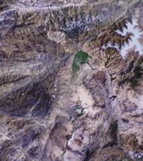
This portion of a Landsat mosaic shows
the wide valley and surrounding mountains just north of Kabul. At the valleys
northern margin is a vegetated alluvial deposit draining from the Panjshir river
valley, which follows a northeast trending fault. Immediately to the northwest
is a pale, elliptical granite pluton intruded into Paleozoic rocks. High, snow-capped
mountains are on the eastern margin.
Caves: natural and manmade
A major military interest in Afghanistan
is locating caves that may hide and shelter terrorists.
Geologic maps could delineate carbonate lithologies expected to contain karst
with natural cave formations; but the number of citations in the literature
for significantly large natural caves in Afghanistan is low. Is this inventory
low because of tectonic instability, a persistently dry climate, or a lack of
exploration?
Manmade caves are apparently abundant in Afghanistan; many are ancient. Caves
were dug for habitation, for religious shrines, mineral extraction and as irrigation
tunnels known as karez.
Because of the lack of detailed geologic maps of Afghanistan, identifying the
lithology at a specific tunnel can be difficult. This problem also holds true
for many other regions around the world. Fortunately, remote satellite imagery,
particularly hyperspectral imagery, can reveal valuable clues to a specific
lithology in an arid region.
The tunnels at Tora Bora, which have become well known in recent months, are
in a category all their own. The area surrounding Tora Bora is known as the
Kohe Sofaid, or also as the Spinghar mountain range. The dominant lithology
is metamorphic gneiss and schist. The tunnels were initially developed during
the Russian invasion by the Afghan mujahedin and apparently expanded in recent
years by Al Qaeda. With his engineering background and financing, Osama bin
Laden used hard-rock mining techniques to expand and enhance the large tunnels.
Many smaller tunnels in the area were also developed using less sophisticated
techniques and appear to be preferentially dug in softer rocks, such as schist,
and others that are highly fractured.
Complete destruction of the larger tunnels will be difficult if they are located
in gneiss or other crystalline rocks. Collapsing the entrance may be the most
that can be accomplished in these more massive rocks. However, a tunnel in softer
rock, such as a clastic sediment, may be more easily destroyed.
Resources for building a nation
A lasting resolution to the conflicts
that have plagued and continue to rattle Afghanistan is nation building. A significant
foundation for nation building is identifying natural resources that enhance
the livelihood of a countrys people and provide stability.
Unfortunately, the most profitable agricultural product in Afghanistan has been
the opium poppy. In this semiarid country, similar to Denver in climate, pockets
of fertile land in the valleys of mountainous regions rely on irrigation via
aqueducts from mountain snowmelt. These isolated valleys have proven ideal for
poppy cultivation. The Taliban successfully outlawed the cultivation of poppies
for a short period, apparently in an attempt to gain favor internationally.
Given the economys reliance on the crop, though, this policy may have ultimately
weakened the Talibans seven-year rule.
Afghanistans other natural resources may not be as profitable as the cultivation
of poppies, but they are diverse and some are abundant.
The countrys geologic mineral resources range from exotic minerals such as
lapis lazuli and other fine gems, for which Afghanistan has been an important
source for many centuries, to more standard ore deposits such as gold, copper
and iron. The Hajigak iron ore deposit west of Kabul has identified resources
of 60 million tons, about half the yearly production of iron in the United States.
Copper occurs in ore similar to the Zambian Copper Belt. Identified resources
are estimated to be 240 million tons, making it a world-class deposit.
Energy resources are apparently limited compared to those of neighboring countries
Iran and Turkmenistan. Yet they are domestically important. Some areas may warrant
exploring with modern technology, considering the countrys long hiatus in exploration
and the abundant structural pockets of reservoir rock. Coal reserves in the
Jurassic of northern Afghanistan, it is estimated, has identified resources
of 90 million tons, comparable to just over half the yearly production in West
Virginia. Identified resources of natural gas, also in northern Afghanistan,
total 60 billion cubic feet, about 10 percent of the United States annual production.
Speculation on undiscovered gas resources exceeds 3,000 billion cubic
feet.
Aside from energy resources native to Afghanistan, transportation of energy
across national borders is another potential resource by virtue of Afghanistans
strategic geography. Plans for pipelines to carry natural gas and oil from other
landlocked countries in Central Asia, particularly Turkmenistan and Kazakhstan,
have been hampered by various conflicts around the Caspian Sea.
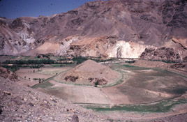 View
to the north of the abandoned meander core of the Ghorband River that flows
east along the right lateral Hari Rud strike-slip fault in central Afghanistan.
The fault cuts directly through and facilitates the meander-neck cutoff. The
Hari Rud fault extends from near the Afghanistan-Iran border on the west to
the Wakhan corridor in the extreme northeast.
View
to the north of the abandoned meander core of the Ghorband River that flows
east along the right lateral Hari Rud strike-slip fault in central Afghanistan.
The fault cuts directly through and facilitates the meander-neck cutoff. The
Hari Rud fault extends from near the Afghanistan-Iran border on the west to
the Wakhan corridor in the extreme northeast.
One route through Afghanistan was pursued in the 1990s by the Argentine Bridas
Corporation and then, in competition, by U.S.-based Unocal. These negotiations
and tentative agreements involved various interests in Afghanistan, including
the Taliban, Turkmenistan, Pakistan, the United States and even Russia. Unocal
sponsored trips of Taliban officials to the United States and contributed considerable
money through the Center for Afghanistan Studies at the University of Nebraska-Omaha
to train people in Afghanistan on pipeline construction. These arrangements
were made during a period when the United States government considered the Taliban
a stabilizing power in an otherwise chaotic country. Ahmed Rashid referred to
them as the New Great Game, an allusion to the political and military competition
of historic proportion between the empires of Great Britain and Russia in the
19th and early 20th centuries. Instability and the onerous policies of the Taliban
derailed these recent efforts.
Once military activities cease, it will be time to implement constructive nation
building. That means making wise and fair use of Afghanistans resources so
that the people of Afghanistan benefit.
Sandstone bluffs surround a chain
of lakes in the Hazarajat region of central Afghanistan. The eight tufa dams
and lakes of Band-i-Amir are 10,000 feet high. Tufa precipitation initiates
when cold carbonate-saturated water flows from the surrounding marine-shelf
carbonates and when the surrounding Cretaceous clastics receive slight solar
warming. The escape of carbon dioxide from water falling over dams, and precipitation
by algae and cyanophytes, also contribute to the carbonate precipitation.
Read Geology
adventures in Afghanistan: An interview with Jack Shroder.
Schindler is a research geologist at the U.S. Geological
Survey. He serves on the Surveys Eastern Geologic Mapping Team and works regularly
as a part of the USGS military geology group. E-mail: sschindl@usgs.gov
