Geotimes

Web Feature
Earth Scientists and National Security
Geotimes
Staff
Welcome to the second annual collection of career profiles in
Geotimes.
Last February, we offered short biographies of earth scientists working off
the beaten track: pursuing careers in such varied fields as journalism, business,
publishing, the space program, policy and consulting. And each person showed
how knowledge of our planet is a powerful tool that can be applied to any career.
This year, we offer glimpses into the lives of seven earth scientists whose
careers have led them into the field of national security. These men and women
are using their geologic knowledge to support U.S. military campaigns, monitor
weapons testing, help navigate a Navy sub, and conduct research in a defense-oriented
national lab. The roster varies: Some of our profilees have Ph.D.s, others have
masters degrees, and one is just starting out. Some knew they loved earth science
when they were young, others discovered it later on. One thing they all have
in common is that a certain element of serendipity put them where they are now.
And that is good to keep in mind no matter what career you pursue.
Seismologist Seismic
Officer Topographic Engineer Naval
Academy Professor
Oceanography Major Meteorologist Structural
Geologist Last
Year's Profiles
Holly Given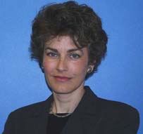
Seismologist
Science Applications International Corp, (SAIC)
When she was working as a seismologist with the Incorporated Research Institutions
for Seismology (IRIS) a few years ago, Holly Given remembers attending an American
Geophysical Union meeting and listening to one earthquake researchers talk. Then
she realized that his data had come from a seismic station she installed.
It was one I built. I stood on the ground and said, build it here. To me thats
more rewarding than doing the research itself, Given recalls .
Installing a seismic station is no easy task. Just finding the right spot requires
geological acumen. If youre in bad geology, it would be like the difference
between a glass and a crystal, Given says. Even more challenging is identifying
the perfect spot for monitoring the low-frequency signals generated by clandestine
underground nuclear explosions.
As a postdoc with the University of California, San Diego, Given, who earned her
Ph.D. in geophysics from the California Institute of Technology, was one of the
scientists involved in a project on detecting nuclear tests during the Reagan-Gorbachev
era. The work brought this Illinois native to Kazakhstan in 1987, her first trip
overseas. There, she installed seismic monitoring stations near the Soviet nuclear
testing ground at Semipalatinsk. These stations would enable Soviet and American
scientists to determine if such monitors could detect the relatively small blasts
of test TNT explosions. Givens postdoc work eventually led her to the IRIS Global
Seismographic Network.
In 1996, more than 130 countries signed the Comprehensive Nuclear Test Ban Treaty
(CTBT), to be carried out by the CTBT Organization in Vienna, Austria. Given recalls,
I knew the organization was starting up. I had some connections. I thought
I could contribute. I was looking for adventure. In 1997, she joined the
staff of seismologists at the CTBT Organization, and has since traveled to Ukraine,
Kazakhstan, Egypt, Oman, Kenya, South Africa, Australia, Spain, New Zealand and
Canada to install seismic monitoring stations.
It was very exciting because everything was new, Given says. We had to take
this vision and turn it into reality. Doing so often required more than scientific
knowledge. Wed have to go into a country and sell the idea of building a seismic
station.
You need to be politically savvy. You need to be sensitive to cultural
differences. Simply doing technical work in a diplomatic setting requires a special
type of personality; or skills and talents.
Given recently left Vienna and started a job with SAIC in Melbourne, Fla. Her
work at SAIC will have her installing nuclear monitoring seismic stations for
the U.S. government.
Given says she finds her work meaningful because she believes nuclear test monitoring
and test limitation agreements can slow the development of nuclear arms. Even
when she was finishing her Ph.D., she realized that research was too solitary
an endeavor for her. In her new job, she is always working on teams. When youre
working within the brotherhood of scientists, even if youre working in a country
where the culture may be very different
theres an inherent communication, camaraderie,
brotherhood, really, thats always nice to find.
Kristina Bartlett
back to index
Michael Hasting
Seismic officer
Comprehensive Nuclear Test Ban Treaty Organization
Michael Hasting is a seismologist who also knows about radio frequency communications.
This skill combination has landed him at the Comprehensive Nuclear Test Ban Treaty
Organization (CTBTO), headquartered in Vienna, Austria. Since he started there
last January, hes traveled to China, Russia, Australia, Spain, England and Canada
upgrading many of the stations around the world CTBTO uses to monitor treaty compliance.
Seismology is a major tool used in detecting whether countries set off clandestine
underground nuclear explosions. But measuring Earths motion is just the first
step. Next, those data must be sent to CTBTO headquarters within five minutes,
from any part of the world, as stipulated by the treaty.
My responsibility would be to get the signal to the seismometer and then to wherever
the communication system is going back to Vienna, he says. In fact, many seismometers
get the data to Vienna within 30 seconds, Hasting says, mainly by satellite communication.
Born in Ridgecrest, Calif., Hasting did not plan on a career in geophysics. After
leaving the U.S. Marine Corps in 1985, he earned an undergraduate degree in the
physical sciences, then took a job at the Naval Air Weapons Station in China Lake,
Calif., not far from where he grew up. There, he oversaw the 16 boreholes the
Navy used to monitor microseismic activity around the geothermal power station
it operated for the area. Hasting found that geophysics suited him: I kind of,
as we used to say, took a hankerin to it. Soon he was on his way to the University
of Nevada at Reno, where the Navy sent him to fine-tune his seismic knowledge
with a masters degree in geophysics.
When Hasting heard about the opportunity at CTBTO, he couldnt pass up the chance
for something new. Several people recommended he apply for it. I like the people.
The travel. Theres a great group of people here in Vienna I work with. Its my
first time working in an international regime.
Kristina Bartlett
back to index
John
Jens 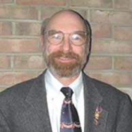
Geologist
U.S. Army Corps of Engineers Engineer Research and Development
Centers Topographic Center
On a day in October 1973, while stationed with the U.S. Army in Nordlingen, Germany,
John Jens was looking at a terrain map of the area where his armor unit was conducting
exercises. He could see that the town sat atop a rise, and that a flat stretch
below the rise surrounded it in an almost perfect circle. He remembers saying,
Thats an impact crater.
His fellow officers looked at him as if he were crazy. But two years later, no
longer ignoring his affinity for maps, Jens was transferred from learning about
tanks to learning about maps and terrain analysis at the Armys topographic mapping
unit, where he would work for 18 years analyzing terrain for military uses. I
found my career, he says. Geology gave me my niche in the Army.
He would also find out that he was right about the crater, eventually identified
as the Nordlingen Reis.
Mapping is not the career Jens originally planned. He originally intended to become
a mineralogist. When he was eight, he caught the geology bug when his mother gave
him a rock collection that had belonged to her cousin, a geologist. In high school,
he created a crystal-growing machine that he displayed at the Iowa State Fair.
Attending the University of Iowa,
Jens had no doubt he would study geology, eventually joining the Army ROTC program
during the Vietnam draft. ROTC carried him through to earning his masters degree
in geology from the University of Montana, funding his thesis on a little-studied
ultramafic intrusion at the Montana/Idaho border. He couldnt convince the Army
to fund his Ph.D., though, and instead he was stationed at Fort Knox to learn
about tanks.
Knowing rocks, knowing terrain, it was easy to take what I knew and apply it
to what they taught me about using tanks in war, Jens says. Jens talent
with maps proved useful in directing tanks across terrain. If there was a map
that needed reading, the senior officers handed it to him.
Topographic mapping not only became Jens career, but also introduced him to something
that changed his outlook on his lifelong love, geology. In 1982, he took a class
formidably titled Interdisciplinary Imagery Analysis Interpretation for Military
and Civilian Applications. The teacher was Robert Frost, a pioneer in aerial
photography interpretation. Frost taught Jens how to deconstruct stereo photos
of an area by various characteristics drainage, vegetation, manmade structures,
rock types, even sinkholes and then put all these pieces together again.
The method is so simple, Jens says. It allows you to truly analyze things.
Analyze means you take it apart. You look at the different parts and then you
put it back together
you can use it to guide actual fieldwork. You have already
done the fieldwork, because the surface of the earth is an expression of geology.
It gave me a very simplified tool in which to fit everything else.
Retired from the Army, Jens is still mapping. Working as a civilian at the U.S.
Army Corps of Engineers Engineer Research and Development Centers Topographic
Center, he uses stereo images, remote sensing images and GIS to analyze terrain
for everything from environmental assessment to lawsuits. Jens now teaches the
same class Frost had taught.
Kristina Bartlett
back to index
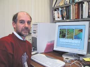
Peter Guth
Oceanography Professor
United States Naval Academy
 Geologists can do anything,
Peter Guth tells his 18 students and two guests during their first day of geological
oceanography at the U.S. Naval Academy in Annapolis, Md. I was hired as a coastal
oceanographer, he says. The students dressed in their winter working blues or
whites contrast with Guths bright red sweater embroidered with a silver trilobite
across the chest.
Geologists can do anything,
Peter Guth tells his 18 students and two guests during their first day of geological
oceanography at the U.S. Naval Academy in Annapolis, Md. I was hired as a coastal
oceanographer, he says. The students dressed in their winter working blues or
whites contrast with Guths bright red sweater embroidered with a silver trilobite
across the chest.
I dont have a clue about geology, Shevonne Wells, a senior, tells me after
class. I hope this course will help open my eyes. She is in luck. One of Guths
specialties is in creating computerized, 3-D topographic visualizations
of viewpoints from any given location.
Peter Guth demonstrates 3-D terrain analysis in his Annapolis office. Photo by
Christina Reed, Geotimes.
Back in his office, Guth demonstrates this technology with a map of Hanging Rock
Canyon, Calif. The contours of the canyons terrain are highlighted as slopes
in gray and black. It starts with digital elevation data, he explains. This
data set has 170,000 elevation points with one latitude and one longitude. From
that one latitude and longitude point you can calculate all the others. Guths
software converts the 3-D map into a model good for operating line-of-sight systems,
planning ambush routes, and other military as well as geological applications.
The thing the military likes is the line-of-sight capability, he says. Pick
any point on the map, hit a key and a fan of green and red color spreads over
the monochrome terrain. Everything in green can be seen from that spot. Everything
in red cannot. The military has a lot of line-of-sight systems, he says. A
lot of the weapons systems, you have to see it to hit it. Lots of the radios are
line-of-sight, so they put a radio tower on top of a mountain up there and see
where it can cover. Radar works the same way. The location he has chosen results
in a mostly red swath. If you put your observation post or your radar antenna
or your radio up there, this is what it would cover, and it is not a very good
spot. So you adjust it before you send somebody up there to climb that hill or
drive to the top of the mountain.
Guth first began working on computer terrain analysis in 1983 while teaching geography
and computer science at the U.S. Military Academy in West Point, N.Y., where he
still returns in summers as a reservist. In 1996, the Army Engineer School at
Fort Leonard Wood, Mo., sought out Guths updated software and collaborated with
him to continue its development.
Today, Guths free software, called MicroDEM, is one of the most popular downloads
from the Naval Academys Web site. Its right up there with the academic schedule
and our leave request form, says spokeswoman Shayne Sewell. But while U.S. elevation
data are freely available from the U.S. Geological Survey, international data
is harder to access. Guths bookshelves are stacked with CDs full of confidential
National Imagery and Mapping Agency (NIMA) data from regions around the world.
The Army recently used MicroDEM during operations in the Middle East and
Bosnia. MicroDEM is primarily for training, but does get used in real-world situations
as a gap filler, says physical scientist Mark Adams of the Army Engineer School.
GIS is very expensive, and we are free.
Geology and terrain analysis followed naturally, from his fascination with the
ancient ruins of Turkey, where he spent part of his childhood. As an undergrad,
he decided to pursue geology at Deep Springs College in California after being
told that regardless of his career path, geology was the neatest course at the
college. From 1969 to 1971, he roamed the desert hills of California collecting
trilobites. He spent the next four years as an undergraduate at West Point, before
he was stationed in Korea. After returning to the United States, Guth earned
his Ph.D. in geology from the Massachusetts Institute of Technology.
In 1983, he returned to West Point to teach. He moved to Las Vegas three
years later to teach at the University of Nevada and work for the USGS. In 1988,
he arrived at the Naval Academy, where he broadened his expertise to include oceanography.
This is the second time in my 13 years at the Naval Academy that I have taught
geological oceanography, he tells the class. One of his students, Amy Jones,
had hydrography and several other courses taught by Guth. He has so much experience
in a variety of fields that he is an invaluable resource for all of the undergraduate
students here at the Naval Academy, she says.
Christina Reed
back to index
Amy Jones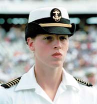
Fall 2001 Brigade Commander
United States Naval Academy
Although geology ultimately led Peter Guth to a career in oceanography, most
of his students are relying on oceanography as a base for careers in other fields.
Guth says, We have about 60 or 70 oceanography majors a year and of those probably
a half dozen or so go into the Navys oceanography community.
During the fall semester, Amy Jones served
as the U.S. Naval Academys Brigade Commander, the highest-ranking position
for a midshipman. Jones was the fourth woman to hold the job since 1980. Photo
by Shannon Bosserman, USNA.
For senior Amy Jones, her background in oceanography will help her when she
goes to sea. Many of the things I learned in oceanography will be applicable
to shipboard life such as predicting weather, waves, tides, understanding
currents and knowing where they are, and understanding atmospheric processes.
I will definitely use these skills each day. But she is not joining the Navys
team of meteorologists and oceanographers.
I am going to become a Nuclear Surface Warfare Officer, she says. That means
attending nuclear power school in Charleston, S.C., and later serving as a nuclear
engineer on an aircraft carrier. In the meantime, however, after Jones graduates
this spring with a bachelors of science degree in oceanography from the Naval
Academy, she will attend Cambridge University in the fall for a masters of
philosophy in environment and development.
I hope to study the application of renewable energy in developing and Third-World
nations. I am specifically interested in solar power, wind power and hydrogen
fuel cells, she says. Since I was a young girl, I have always been very interested
in environmental studies. She also enjoys the outdoors and began oceanography
as another excuse to get outside and understand what I was seeing. She advises
other students to think about broad undergraduate degrees, such as oceanography.
I thought oceanography was a great undergraduate degree because I really gained
a lot of experience in every science field. With a degree in oceanography I
could study virtually any science and go in any direction I chose.
Christina Reed
back to index
Mike Cavanaugh
International Weather Producer
Cable News Network (CNN)
Weather and seas have affected military decisions and operations throughout world
history. Light rain led to a muddy Waterloo and washed away Napoleons chances
of winning the battle. Rain helped George Washington escape from the British after
the Battle of Trenton. And the Spanish Armada suffered a devastating loss in rough
seas in its attempt to invade England. All of these, Mike Cavanaugh says, are
famous examples of how quickly the environment can change the course of war.
At his desk in the CNN International weather studio in Atlanta, Cavanaugh thinks
back to his days in the U.S. Navy: I enlisted in the Navy right after my 17th
birthday. My father swore me in. He was in the Navy at the time.
After serving in the Navy reserve during his last year in high school, he became
a Quartermaster Striker, one of whose duties is taking weather observations. After
obtaining a bachelors degree at Penn State through the NROTC, he became a Surface
Warfare Officer. He then went on to the Navys post-graduate school in Monterey,
Calif., earning a masters degree in meteorology.
Throughout his 23 years of commissioned service in the Navy, Cavanaugh served
in a variety of positions and went through a number of title changes. Early on,
the Navy grouped all oceanographers and meteorologists together as naval geophysicists,
later called naval oceanographers. We were expected to answer questions about
the bottom of the sea to the top of the sky. But whatever the title, he says,
if you checked my blood type youd find I was a meteorologist.
Many different locations also defined Cavanaughs career. In Rota, Spain, he forecasted
weather for the Mediterranean.
In Newport, R.I., he taught war fighting and the environment at the Naval War
College. In Guam, he managed officers at the Oceanography Command Center and Joint
Typhoon Warning Center. And in Annapolis, Md., he chaired the oceanography department
at the U.S. Naval Academy, where he developed a tropical meteorology course. In
each place, he continued to learn about everything from satellites and acoustics,
to tropical storms and specialized local weather effects.
Ten years ago, Cavanaugh decided to take a job at CNN to help create a team of
international weather forecasters. The prospect of having a chance to make
a forecast for the whole world and have it go out to the entire world, I found
extremely exciting. And thats what Im doing.
Cavanaugh has enjoyed the transition, although he admits the military and newsroom
environments, while both exciting, are different in tone. Its no longer a life
and death situation, its only TV, he says. In the civilian world, you know
they say theres a 40 percent chance of showers this afternoon. A Navy commanding
officer doesnt want to hear about a 40 percent chance. He wants to know if its
going to rain, and if it is, when.
Theres nothing quite like the adrenaline rush standing in front of the commanding
officer and having him ask you a question, Cavanaugh remembers, chuckling. Especially
if you know he is going to take what you say and do something about it.
Lisa M. Pinsker
back to index
Claudia Lewis 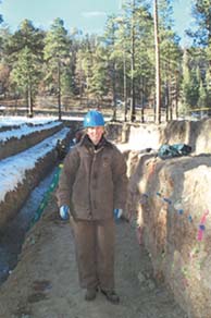
Technical Staff Member
Los Alamos National Laboratory
Claudia Lewis had always loved the natural world, but thought that understanding
it scientifically was out of her reach. Now a technical staff member in the
Department of Energys Los Alamos National Laboratory in New Mexico, Lewis reflects
on her circuitous route to becoming a geologist. I have kind of a checkered
history, Lewis says.
As a sophomore at Brown University in Providence, R.I., Lewis considered majoring
in geology, but I chickened out because I had a really weak science and math
background and I was scared of the calculus and the physics. So, I ended up
majoring in American civilization, she recalls.
Claudia Lewis in a trench site for a new
Los Alamos National Laboratory Emergency Operations Center.
In her senior year, though, Lewis took an ecology class and loved it. And after
college, she moved to New Mexico to work as a lab technician at an independent
wood energy research lab. It was there I discovered hey, I can do science.
And so I started taking courses one at a time at some of the local colleges
I took chemistry and college algebra and calculus and geology. And then I
thought: Well this is fun. Why dont I go and get a geology degree.
And she did. Lewis went on to get a masters degree at California State, Los
Angeles, and a Ph.D. at Harvard University, and then carried out her postdoctoral
work at Los Alamos all in geology. In the end it took me nine years. I ended
up going through 26th grade, but it was worth it.
Lewis learned early on that she could gain experience and develop skills in
a variety of fields, and ultimately transfer those acquired skills to a career
she loves. As a Ph.D. student, you learn not just specific techniques, but
also particular work habits and ways of doing things. And those skills transfer
directly to this environment that Im in, as well as many other non-traditional
career paths skills, like thinking independently, directing your own research,
supervising other people and planning field work, foreign travel or an experiment.
Likewise, Lewis says that the results of what she does professionally are often
transferable. Part of what I really like about my job is that there is a lot
of basic science, and thats part of what keeps it really exciting. An example
is her current work at Los Alamos, where she studies earthquake hazards to the
Los Alamos site and fault fabrics related to fluid flow. This work applies directly
not only to Los Alamos, but also to the Yucca Mountain proposed nuclear waste
repository site.
Lewis also has a Fulbright grant to study tectonic processes in Spain, identifying
mechanisms that control river incisions in an area that experiences little tectonic
activity. While her work is not classified, she explains, other people in her
division work on a broad range of projects tackling complex national security
problems, such as energy security, seismic monitoring of nuclear tests and environmental
issues.
Lewis says working in a national laboratory is both similar to and different
from working in an academic setting. Just as at a university, the lab addresses
both basic and applied research, and hosts a lively student environment. But,
she says, the mood is different because of the focus on national and energy
security. Maybe our research isnt as curiosity-driven as research in universities.
We tend to be more focused on a mission, and that mission really ties together
all individual efforts.
Lisa M. Pinsker
back to index
