Geotimes
Geophenomena
The
years first big one a shudder Australian
fires contained Moving
in on danger Web
sites for Earth watchers
The
years first big one a shudder
The
years first severe earthquake, of magnitude 7.2, struck the remote South
Pacific island nation of Vanuatu on Jan. 2. Damage to roads and bridges
occurred on the main island of Éfaté, where landslides and
falling boulders cut off the wharf in the capital city of Port Vila. The
Vanuatu Red Cross team reported treating 190 people for injuries, and counseling
another 100 for shock. Residents fleeing their homes during the early morning
tumbler feared the quake would create a large tsunami.
"People
living in low-lying areas saw the level of the sea go down. This prompted
them to expect a tsunami," says Peter Pamara, the Vanuatu Red Cross disaster
response team coordinator. The resulting wave that struck, however, measured
only 80 centimeters from peak to trough, according to the national tidal
facility at Port Vila.
In
November 1999, a magnitude-7.2 earthquake hit the island nation and generated
a tsunami on the northern Pentecost Island that surged 2 kilometers ashore
and swept five people out to sea. Two of the bodies were never recovered,
according to the International Tsunami Information Center. Five others
were killed from collapsing houses and thousands were left homeless.
The
mildness of this years tsunami was likely due to its depth and distance
from shore, says Eric Geist of the U.S. Geological Survey in Menlo Park,
Calif. The earthquake struck 50 kilometers from Éfaté at
a depth of 21 kilometers. In 1999, the earthquake struck closer to Pentecost,
90 kilometers from Éfaté and at a depth of 8 kilometers.
"A shallower earthquake means potential for a bigger tsunami," Geist says.
Vanuatu
sits on the rim of the 9,165-meter deep New Hebrides trench, between New
Caledonia and Fiji. The volcanic island arc results from the Indo-Australian
plate subducting beneath the Pacific plate. "The 1999 quake occurred on
the back-arc region of the New Hebrides volcanic island arc, whereas the
one this year hit in the typical subduction zone," Geist says. Aftershocks
continued to rattle Vanuatu, with an earthquake the following day reaching
a magnitude of 6.6.
Christina Reed
Australian
fires contained
On Jan. 14, rain and favorable
weather in parts of Australia helped firefighters bring under control the
last of the fires that blazed around Sydney for three weeks. Containment
lines and back burning gave the firefighters an upper hand in wrestling
flames that had shot up from winds of up to 30 miles per hour on Jan 12.
 The
disaster destroyed more than 650,000 hectares of New South Wales, razing
more than 150 homes along the way. As many as half of the original 100
bush fires are considered acts of arson. And since Christmas day, authorities
have questioned 34 people 10 adults and 24 juveniles, the youngest nine
years old. The fires killed or evicted countless numbers of koalas and
other wild animals that live in the Eucalyptus forests. The operation to
control the crises is estimated to cost the state's government at least
$AUS70 million ($30 million U.S.), with a similar level of expense to insurance
companies.
The
disaster destroyed more than 650,000 hectares of New South Wales, razing
more than 150 homes along the way. As many as half of the original 100
bush fires are considered acts of arson. And since Christmas day, authorities
have questioned 34 people 10 adults and 24 juveniles, the youngest nine
years old. The fires killed or evicted countless numbers of koalas and
other wild animals that live in the Eucalyptus forests. The operation to
control the crises is estimated to cost the state's government at least
$AUS70 million ($30 million U.S.), with a similar level of expense to insurance
companies.
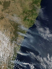
This
true-color image from NASA's Moderate-resolution Imaging Spectroradiometer
(MODIS) shows bush fires surrounding Sydney on Jan. 2. Vast smoke plumes
ascend from the southeastern coastline of Australia and extend over the
Tasman Sea.
In an effort to curb bush
fire hazards in the future, the New South Wales government introduced legislation
that will give the Rural Fire Service power to enter residential properties
to clear vegetation and conduct other hazard-reduction techniques without
obtaining permission from the homeowners. The new laws will also require
that local councils consult with the fire service when managing residential
or other developments in fire-prone areas.
Christina Reed
Moving
in on danger
 In
December 2001, geologists expressed concern over the potential threat to
nearly one million people living on the flanks of El Misti Volcano in Peru.
The volcano currently shows no sign of activity, but a detailed study on
El Misti, published in the Geological Society of America Bulletin, stressed
future risk and offered new support for safer development.
In
December 2001, geologists expressed concern over the potential threat to
nearly one million people living on the flanks of El Misti Volcano in Peru.
The volcano currently shows no sign of activity, but a detailed study on
El Misti, published in the Geological Society of America Bulletin, stressed
future risk and offered new support for safer development.
"Future eruptions of El Misti,
even if moderate in magnitude, will entail considerable hazards to the
densely populated area of Arequipa," warn Jean-Claude Thouret of the Université
Blaise Pascal in France and his team of French, Peruvian and British scientists.
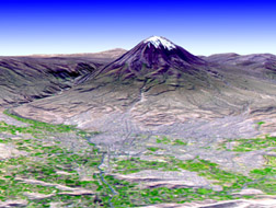
This
3-D view was created from an Advanced Spaceborne Thermal Emission and Reflection
Radiometer (ASTER) Digital Elevation Model combined with a simulated natural
color ASTER image. It shows El Misti volcano in Peru towering 5,822 meters
above sea leve1 and 3.5 kilometers above Arequipa, which has a population
of 750,000.
Spain founded the town of
Arequipa at an oasis on the bank of the Rio Chili in 1540, but the town
also happened to lie in a depression between two ancient volcanic flows.
With the global population increase after World War II the town surged
from 86,000 in 1940 to 677,000 in 1995. Today 750,000 people live in Arequipa,
while the city center lies 17 kilometers from the summit vent and 3.5 kilometers
below it in elevation.
"Anyone who has flown into
the airport at Arequipa is very aware of the risk," says Simon Young, a
volcanic hazards consultant in Florida.
Thouret and colleagues studied
El Misti's eruptive history and provided geologic maps depicting the main
drainage channels and areas of debris avalanche deposits; rockslides; and
pyroclastic, pumice and lava flows. The last eruption occurred between
1440 and 1470 with phreatic events recorded in 1677, 1784 and 1787.
"We think that the recent
studies of Jean-Claude Thouret are in agreement with a large consensus
of volcanologists," says Henry Gaudru, president of the European Volcanological
Society and International Commission on Mitigation of Volcanic Disasters
in Geneva, Switzerland. "This recent work is very interesting and should
be integrated in the future risk assessment plan to mitigate volcanic impact
for the population living in Arequipa."
While earthquakes regularly
shake this region and landslides may pose more of an immediate threat,
"the possible impact of Misti on Arequipa is as worrisome as that of Vesuvius
near Napoli," Thouret says. He and his colleagues urge the implementation
of emergency response policy and land-use planning to help regulate city
growth. "Future growth of the city should be preferentially oriented southeast
and west of the depression but beyond 25 kilometers from the vent."
Christina Reed
Web Sites
for Earth Watchers
Earthquakes:
For global coverage of new
and past earthquakes check out the USGS
National Earthquake Center.
The Incorporated
Research Institutions for Seismology (IRIS) monitors seismic data and
provides interactive maps.
Volcanic Eruptions:
The Smithsonian
and the U.S. Geological Survey report weekly on volcanic activity around
the world.
Stunning photography and
in-depth reports adorn the Web pages of Stromboli
on-line, which covers the ongoing activity of its namesake island volcano.
Links to other volcanoes are included.
Floods:
The U.S.
Geological Survey provides maps and graphs of current water resources
conditions.
