
 Although far from
any plate boundary, the middle of the United States has more than 200 small-magnitude
earthquakes annually. Few cause any damage or are even felt, but St. Louis and
Memphis, along with gas pipelines, highways and railroads, are at risk from
earthquakes similar in magnitude to those that struck in 1811 and 1812. These
historic quakes, with estimated magnitudes reaching 8.2, rang bells in Boston
and rattled residents as far away as Quebec.
Although far from
any plate boundary, the middle of the United States has more than 200 small-magnitude
earthquakes annually. Few cause any damage or are even felt, but St. Louis and
Memphis, along with gas pipelines, highways and railroads, are at risk from
earthquakes similar in magnitude to those that struck in 1811 and 1812. These
historic quakes, with estimated magnitudes reaching 8.2, rang bells in Boston
and rattled residents as far away as Quebec. Now geologists have upgraded a suspected rupture area in the New Madrid seismic zone to fault status, marking a surface fault in a region where earthquake hazard maps currently identify the extent of potential danger zones principally by seismic activity. Indeed, in a separate study incorporating 15 years of seismic research, scientists from the U.S. Geological Survey (USGS) and the Center for Earthquake Research and Information at the University of Memphis now estimate a 7 to 10 percent chance that in the next 50 years such large-magnitude earthquakes will strike again. They also estimate that there is a 25 to 40 percent chance that a magnitude-6.0 or greater earthquake could occur in the next 50 years. These probabilities, announced on Jan. 13, raise the concern for another 1811-1812 series of earthquakes.
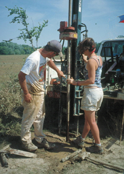
Students Danny Fitzgerald and Erica Doerr of the University of Arkansas drill cores for research on the New Madrid seismic zone. Photo by Margaret Guccione.
“Even though the chances of a mid-sized earthquake are reduced, the chances of a devastating earthquake in the region have risen,” says Eugene Schweig of the USGS in Memphis.
The 1811-1812 earthquakes, centered near New Madrid, Mo., caused extensive liquefaction, ground failure and bank caving, landslides along river bluffs, and surface deformation large enough to impact the flow of the Mississippi River, impound a creek to form Reelfoot Lake in Tennessee, and uplift a dome above normal flood level of the Mississippi River flood plain, says Margaret “Peggy” Guccione of the University of Arkansas. With such devastation, she would expect a surface rupture somewhere to show for it. Only two features, the Bootheel lineament and the Reelfoot scarp, are considered potential suspects; but neither provide a clear-cut surface rupture. Investigating the Bootheel lineament using cores, Guccione found buried evidence of vertical displacement and indications of horizontal motion as well. She presented her findings in a poster presentation at the American Geophysical Union meeting in December in San Francisco.
“A lineament is a term geologists use when they don’t know what it is,” says Arch Johnston of the University of Memphis. “Now, after Peggy’s work, I’ll be calling it the Bootheel fault from now on.”
Unlike satellite images of the San Andreas fault that show where the same geologic features east and west of the fault have laterally diverged due to the strike-slip movement of the North American and Pacific plates, aerial images over the New Madrid seismic zone show a hodgepodge of clues that are difficult to recognize as evidence of past earthquakes. Filled river channels end suddenly; sand blows across one spot more than another; shallow depressions line the ground. From the air, these types of clues form a 135-kilometer-long, suspicious-looking feature that extends from Marked Tree, Ark., to New Madrid through the Bootheel of Missouri, an area of the state that steps down into Arkansas.
To determine whether or not a feature represents a surface rupture from an earthquake in New Madrid requires detective work that often involves digging shallow trenches to uncover geologic differences between areas. But at this location a trench would have needed to have been 6 meters deep, extending it below the water table, to uncover evidence for a fault — a project too expensive and dangerous for a preliminary study and one that could wreak havoc on the neighboring farmland. With funding from the USGS, Guccione took a simpler approach. By drilling over a hundred closely-spaced cores that could extend to the necessary depth across the suspected feature she, along with co-author Ron Marple of WesternGeco in Houston and several Arkansas students, identified the tectonic offset that distinguishes a fault.
Taken along a small infilled channel that the Bootheel lineament truncates, the cores on the east of the lineament showed little change in the land during the last 12,000 years. But the cores to the west of the lineament, less than 10 meters away, showed a depression, probably formed by several earthquakes. An earthquake between 12,000 and 10,000 years ago formed the initial depression that was filled with clay from flooding of the Mississippi River. Guccione also found signs of an earthquake that struck around A.D. 1470, creating a burst of liquefied sand through the clay layer. Her cores showed that flooding of the Mississippi River deposited more clay that covered the liquefied sand and filled the depression that had formed again. Liquefied sand, but no depression, formed during the 1811 earthquake. Cores also showed that the small infilled channel was buried by the clay and liquefaction deposits west of the lineament, and that the channel was laterally offset by faulting from its position east of the lineament.
“We assumed that one reason we don’t see a fault offset on the Bootheel is because it is a strike-slip fault on an active floodplain and the Mississippi washed the evidence away during flooding,” Johnston says. “The surprising thing with Peggy’s work is she showed significant vertical displacement on the Bootheel, in addition to the expected horizontal displacement.”
The lack of seismicity along the Bootheel fault lends an air of mystery to the region however. “Perhaps a rearrangement of stress has made the area inactive for the moment,” Schweig suggests. He adds that Guccione “made a reasonable interpretation and didn’t have to dig everything up. She took small cores, so the area is still available for other people to investigate.”
Christina Reed
