Geotimes

Feature
Stories from the
Underground
Geotimes staff
Every February, Geotimes offers snapshots of a few geoscientists and their
careers. This year, we looked deeper to find out about several whose work takes
them inside Earth. We focus not only on the paths these adventurous scientists
have followed in their lives, but also on the details of their work surroundings
— which for this group can reach up to 300 meters below the surface.
Underground town
Indiana Jones and the Dead Sea
Scrolls
Adventures in cave exploration
Underground
town
 Early in the morning,
David Leach and two other geologists from the U.S. Geological Survey (USGS) hop
into a truck and head into the Ozarks in southeastern Missouri. They wind through
hardwood forested hills and alongside emerald streams. Eventually, a small clearing
opens up, dotted with a tailings pond, a mill and a small head frame housing a
shaft leading down to a lead mine.
Early in the morning,
David Leach and two other geologists from the U.S. Geological Survey (USGS) hop
into a truck and head into the Ozarks in southeastern Missouri. They wind through
hardwood forested hills and alongside emerald streams. Eventually, a small clearing
opens up, dotted with a tailings pond, a mill and a small head frame housing a
shaft leading down to a lead mine.
Since the discovery of a rich lead district in the Ozarks more than 40 years ago,
the Doe Run Company has mined more than 140 million tons of ore that contains
lead, zinc and copper — making the company the largest lead producer in North
America. The ore lies in a 40-mile-wide strip called the Viburnum Trend that runs
beneath the Ozarks. Doe Run has proposed to explore for more lead deposits in
the Mark Twain National Forest, south of the current mines. Leach and his crew
are here as part of a study to determine how the expanded mining might affect
the quality of the region’s surface water and groundwater.
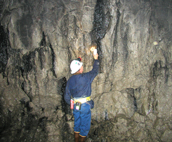
Dennis Murphy, leader for the Doe Run Company
Environmental Group, collects a water sample from a discharge along a mine face
in the Viburnum Trend. Photo by David Leach.
The geologists don hardhats and safety gear and squeeze into a small metal cage.
The door shuts and the elevator slowly descends more than 300 meters into the
ground. Their headlamps cast faint patches of light onto the otherwise dark walls
of the mine.
When they reach the bottom, the cage doors open, bringing into focus a sight that
contrasts starkly with the claustrophobic descent. “It is like a small town
— two-million-dollar rock movers and heavy machinery. The walls are painted
white; there are lights, refrigerators and pick-up trucks. And all of this huge
equipment was brought down the same shaft, piece by piece, and re-welded underground,”
Leach says.
An environmental geologist working with the Doe Run Company pulls up to the group
in a tractor. The USGS scientists jump on board. A series of interconnected roads
takes the team 10 miles along the Viburnum Trend. The tractor dodges trucks loaded
with rocks on the surprisingly smooth, gravel roads. They stop at a point where
water trickles out of a crack in the wall.
For the past 30 years, Leach has studied the origins of ore deposits like the
ones in the Viburnum Trend. Now he finds himself on the opposite end of the equation,
investigating not how minerals made it into the deposits but how toxic metals
might make it out. He is part of a research team developing a model that uses
data on the geochemical and hydrologic properties of local rocks to predict how
future mining, in similar sites, could impact the mobilization of toxic metals
and other chemicals.
“In many ways, the environmental issues are the inverse of the ore formation
processes. Hot waters bring the minerals in and they precipitate by chemical reduction.
And to mobilize the minerals, you oxidize them and move them out in water,”
Leach says.
Leach and his fellow researchers get out pH and conductivity meters and jot down
results characterizing the seeping water. They fill sample bottles. Back in the
lab in Denver, Colo., they will analyze the samples for lead, arsenic and other
toxic metals.
Mining for lead along the Viburnum Trend requires de-watering: constantly pumping
groundwater out from the mine and onto the surface. The groundwater would otherwise
fill the mine. That process introduces oxygenated water to rocks that have been
sitting in oxygen-poor groundwater. A primary concern is that minerals in the
rock will react with the oxygen, lowering the pH of residual groundwater and mobilizing
metals contained in the ores. Migration of this tainted groundwater through the
highly permeable karst bedrock might contaminate the network of springs and rivers
that characterize the Ozarks and provide drinking water to many of Missouri’s
citizens.
However, karst is a double-edged sword. Limestone, while permeable, also buffers
acidic waters, weakening their acidity. This buffering can prevent mobilization
of toxic metals. “The question is: When the oxygenated waters interact with
the ores, do you get classic acid mine drainage or is the system effectively buffered
by the carbonate rocks?” Leach says.
Through samples from this mine, and samples from more pristine areas, a general
picture is evolving. The buffering from the limestone bedrock seems to do a good
job limiting the migration of toxic metals in the region, Leach says. Sulfate
is another story. It does not react with the limestone; of all the chemicals analyzed
to date in the waters in the mining areas, only sulfate can exceed the Environmental
Protection Agency’s standards for drinking water.
After 10 minutes of sampling, the geologists hop back onto the tractor, and drive
another half hour along the Viburnum Trend. Again, they stop at a site where water
comes out of the rock, but this time it is flowing rapidly, as if an open hose
is stuck between the rocks. Leach takes notes about the rocks adjacent to the
water source while his colleagues continue the sampling, which they have pared
down to an efficient set of steps.
In one way or another, Leach has been investigating rocks for most of his life.
“I knew from day one that I was interested in geology. I was a mineral collector
in elementary school. My neighbor worked in a feldspar mine when I was a kid.
Then in high school, I won a science fair and said to myself ‘This is pretty
neat.’” Later he earned a science fellowship to Virginia Tech and went
on to get a Ph.D. from the University of Missouri at Columbia, studying the origin
of lead ore deposits.
His advice to future geologists, especially those interested in adventuring underground,
is to get a broad-based training. “Know chemistry, know physics. What has
made me successful is not just knowing ore deposits, but also knowing about other
areas in science such as environmental geochemistry.”
Greg Peterson
Back to top
Indiana
Jones and Dead Sea Scrolls
At this time it was that the fight happened at Actium, between Octavius
Caesar and Antony in the seventh year of the reign of Herod and then it was
also that there was an earthquake in Judea, such a one as had not happened at
any other time, and which earthquake brought a great destruction upon the cattle
in that country. About ten thousand men also perished by the fall of houses;
but the army, which lodges in the field, received no damage by this sad accident.
-Josephus (ca. A.D. 37-100)
Geophysicist Amos Nur views ancient history as a series of earthquakes: the
fall of the Mayan civilization, the end of the Bronze Age in the Eastern Mediterranean,
level after level of destruction at Troy, Jericho and Megiddo. They all shared
a similar, geologically explained fate, says Nur of Stanford University.
 Located about a
mile from the Dead Sea Transform fault, Jericho was destroyed at least 22 times
in history according to archaeological evidence. The Old Testament recounts
the story of Joshua’s conquest of Jericho, which would have been around
1250 B.C., but that is only one story in the history of a city 10,000 years
old. Nur says that historical and archaeological records show evidence of several
earthquakes about every 500 years, including the devastating quake of 31 B.C.
described by the historian Josephus.
Located about a
mile from the Dead Sea Transform fault, Jericho was destroyed at least 22 times
in history according to archaeological evidence. The Old Testament recounts
the story of Joshua’s conquest of Jericho, which would have been around
1250 B.C., but that is only one story in the history of a city 10,000 years
old. Nur says that historical and archaeological records show evidence of several
earthquakes about every 500 years, including the devastating quake of 31 B.C.
described by the historian Josephus.
Accounts such as these are rarities, however, in the historical record. Geophysicists
like Nur must turn to the archaeological world for more clues on these destructive
forces of the past. “We try to interpret archaeological evidence in terms
of earthquake damage as opposed to the other common explanations, which are
war and time,” Nur says.
Nur is trying to help archaeologists think about the nature of the ruins they
uncover. “Most of them have never taken a geology course; they don’t
know anything about earthquakes. And so it was kind of a revelation for many
of them.”
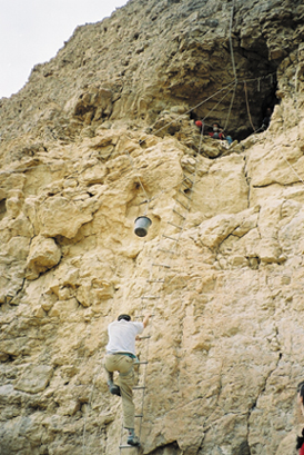
In November, a team of archaeologists
and geophysicists climbed into a cave in the Dead Sea region, where they found
ancient papyrus scrolls, coins and arrowheads, probably from about A.D. 130.
Photo by Amos Frumkin, Hebrew University.
At the same time, Nur wants to use archaeological findings to better understand
the spatial and temporal distribution as well as the magnitude range of past
earthquakes. For this, he is turning to caves, hoping to discover evidence of
past earthquakes through buried remains that will allow him to reconstruct a
seismic past for the Eastern Mediterranean. “There are very few places
in the world where human history is long enough and the archaeological finds
are abundant enough.”
The excursion of paleoseismology into caves is a relatively new field, says
Elisa Kagan of the Geological Survey of Israel. A seismologist herself, Kagan
uses stalagmites, stalactites and fallen rocks to date Israeli caves going back
200,000 years, which she also believes collapsed from large earthquakes.
“Short records are not enough. Archaeology brings us further back in history
and then geology brings us even further back,” she says. “The importance,
of course, of all these types of work is to understand earthquake patterns because
they are more complicated than what can be understood from the history alone.”
In the rubble and ruin of some caves in the Dead Sea region, Nur wants to find
the missing pieces of a puzzle that began almost a half century ago. “I
was looking at historical earthquakes and their effect on archaeology for many
years when it became apparent to us that the Dead Sea Scrolls, which were found
about 45 years ago or so, were all found in caves under rubble,” Nur recalls.
The Dead Sea Scrolls are believed to hold great clues about the way of life
for a small Jewish sect of people called the Essenes as well as about the emergence
of early Christianity.
He and his colleagues believe that over time several earthquakes, including
the 31 B.C. earthquake, may have buried older scrolls and some of the scroll
writers. This hypothesis has led him to the caves themselves — places he
never imagined visiting when he started off studying earthquake prediction at
the Massachusetts Institute of Technology more than 30 years ago.
 In 1996, he and
colleagues climbed up into the Cave of Letters, one of many caves that sit in
limestone cliffs overlooking the Dead Sea. The Dead Sea is a pull-apart basin,
a deep depression 400 meters below sea level, created by the Dead Sea Transform
fault. “So the caves are on the margin of this pull-apart basin, right
smack on the fault,” Nur explains. Based on the extent of damage revealed
by archaeological work in the caves, Nur’s team also can estimate the maximum
earthquake magnitude possible on the Dead Sea Transform fault.
In 1996, he and
colleagues climbed up into the Cave of Letters, one of many caves that sit in
limestone cliffs overlooking the Dead Sea. The Dead Sea is a pull-apart basin,
a deep depression 400 meters below sea level, created by the Dead Sea Transform
fault. “So the caves are on the margin of this pull-apart basin, right
smack on the fault,” Nur explains. Based on the extent of damage revealed
by archaeological work in the caves, Nur’s team also can estimate the maximum
earthquake magnitude possible on the Dead Sea Transform fault.
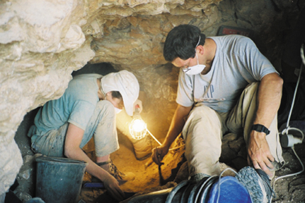
Archaeologists from Hebrew University
in Jerusalem unearth a papyrus document found in a small cliffside cave in the
Judean Desert, as part of a cave survey. The documents could tell researchers
about a time period which saw a Jewish rebellion against the Romans in the second
century. Through the surveying work, geophysicists hope to find older artifacts
in order to reconstruct a 31 B.C. earthquake event that may have buried the
writers of the Dead Sea Scrolls. Photo by Amos Frumkin, Hebrew University.
Specifically on this expedition, they were searching for a crushed skeleton
an Israeli archaeologist claimed to have seen during a 1953 Dead Sea Scrolls
expedition. As datable organic remains, the skeleton is unique from other, non-organic
archaeological evidence. “If these ceilings didn’t fall on something
organic, they may not be able to date them [collapsed ceilings],” Kagan
explains. “Otherwise, maybe the archaeology is 2,000 years old and the
ceiling fell yesterday.” If found and dated to before 31 B.C., the crushed
skeleton could suggest that the 31 B.C. earthquake buried the scroll writers.
The cave ended up being too large and difficult to excavate. “The entrance
to the cave was about a square foot … the floor was littered with boulders
about 20 feet high and 20 feet across. It was pitch dark, no daylight ever;
there were bats and bat manure. Even if you were not a claustrophobic you would
become one,” he recalls.
Unable to find the crushed skeleton, they decided to turn to smaller caves nearby.
Since then, in a collaboration of Stanford University with Hebrew University
and Bar-Ilan University in Israel, a team of geologists and archaeologists has
entered about 200 caves in the region. In November, the research group announced
that they found in one of the caves ancient papyrus scrolls, coins and arrowheads,
probably from about A.D. 130. Nur believes that much more remains to be found.
He eagerly awaits his next cave expedition this month, hoping to find material
old enough to prove their earthquake hypothesis. “Just call this Indiana
Jones and the Dead Sea Scrolls.”
Lisa M. Pinsker
Back to top
Adventures
in cave exploration
The stench
of hydrogen sulfide gas emanates from the mouth of Cueva de Villa Luz, in Mexico,
an indication of the cave’s formidable environment. A person who spends too
much time inside the limestone labyrinth could die from the fumes. Geologist Louise
Hose is no stranger to the smell, but ever since her first visit to the cave in
1996, she and her caving companions don gas masks and gas monitors while wading
through the cave’s warm, white mineral streams to investigate its dark interior.
 Every year, nearby
villagers perform a traditional ceremony of asking the Zoque gods permission to
enter the cave and harvest its unique bounty of fish. They quickly collect basketfuls
of the sardine-sized mollies for food from a stream inside the cave’s main
entrance. Two years ago, Hose witnessed a harvest that yielded 45 pounds of fish.
In any other cave, this practice would collapse such a rare commodity, she says,
one of the many distinctions that make Cueva de Villa Luz her favorite.
Every year, nearby
villagers perform a traditional ceremony of asking the Zoque gods permission to
enter the cave and harvest its unique bounty of fish. They quickly collect basketfuls
of the sardine-sized mollies for food from a stream inside the cave’s main
entrance. Two years ago, Hose witnessed a harvest that yielded 45 pounds of fish.
In any other cave, this practice would collapse such a rare commodity, she says,
one of the many distinctions that make Cueva de Villa Luz her favorite.
The secret behind the cave’s plentiful source of fish is sulfuric oxidizing
bacteria that not only feed the fish, but also hang from the walls and ceilings
generating gelatinous, slug-like and stalactite-dripping sulfuric acid Hose and
her colleagues call “snottites.” Drop by drop, they create the cave’s
cavernous hallways and crag-like tunnels. “When I first heard about colonies
of microbes living in the cave, I assumed they were little things in a corner,
not this dramatic feature carving out the entire cave,” Hose says. What makes
the environmental conditions just right for the bacteria to take such an active
role in the cave’s formation and whether the bacteria have pharmaceutical
benefits are just two of the questions Hose hopes student geomicrobiologists following
in her footsteps will answer.
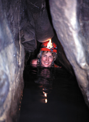
Louise Hose takes a swim to check out a
passage in a water-filled cave in Tabasco, Mexico. Photo by James Pisarowicz.
“Right now the whole geomicrobiology area is pretty exciting. Most of us
10 years ago getting our degrees didn’t consider it as a career,” she
says. “Now a large number of institutes are looking to add geomicrobiology
to their list. A degree program that focuses on mineralogy, geochemistry and microbiology
is a winning combination right now. Students with that kind of training could
go into pharmaceutical work, groundwater remediation or studying things as diverse
as how caves form or what kind of life survives in volcanoes. It is esoteric,
but we are finding life in places we never dreamed of before.”
Hose grew up in the Los Angeles area and teamed up with other cavers while she
was an undergraduate at California State University (CSU) to explore caverns in
the Sierras and the Mojave Desert. “I quickly became interested in geology
but the faculty discouraged me, as a woman, from pursuing it as a career.”
This was 1971. She moved to Arizona where she obtained her bachelor’s degree
in secondary education and spent three years as the athletic coach and P.E. instructor
that students also came to for questions about physical science. When she returned
to CSU in Los Angeles for a master’s degree in geology the atmosphere had
changed dramatically. “In 1973 and 1974 the federal government put pressure
on oil and mining companies to hire women,” Hose explains.
Her graduate studies took her to a karst area in Tamaulipas, Mexico, the site
of the Western Hemisphere’s deepest explored cave at that time. In 1990,
Hose received her Ph.D. from Louisiana State University in Baton Rouge for her
work on the Barberton Greenstone Belt in South Africa. She has worked as a contract
geologic consultant and writer helping with television documentaries, conducting
forensic studies and geologic investigations. Until recently, she also taught
geology at Chapman University in Orange, Calif. In 1999, National Geographic Adventure
featured Hose in their Explorers for the Millennium issue and in 2000, Outside
Magazine named her one of 25 All-Star Athletes and Adventurers.
In December, Hose started as director of the National Park Service’s National
Cave and Karst Research Institute, based in Carlsbad, N.M. She is in charge of
promoting education and directing resources to help fund research in cave and
karst communities. “Microbial studies are particularly fascinating, but also
we will be working on groundwater contamination and pollution, subsidence and
general engineering and education so folks living in a karst region can better
understand the nature of the area they live in,” she says.
Christina Reed
Back to top
