Geotimes

Feature
Building
the World's Largest Rail Tunnel
Simon Löw and Herbert Einstein
 Switzerland
will soon boast the world’s longest rail tunnel, one that will stretch 57
kilometers. In an effort to improve its rail system, the country is in the midst
of a huge construction project to build two new rail tunnels through the Alps.
The tunnels will cut through the mountains deeper than any other tunnel, as the
country is pressured to increase its transportation system’s capacity for
rail freight.
Switzerland
will soon boast the world’s longest rail tunnel, one that will stretch 57
kilometers. In an effort to improve its rail system, the country is in the midst
of a huge construction project to build two new rail tunnels through the Alps.
The tunnels will cut through the mountains deeper than any other tunnel, as the
country is pressured to increase its transportation system’s capacity for
rail freight.
The tunnels will cross important parts of the deeper core of the Swiss Alps, which
have a complex tectonic and metamorphic history. Both base tunnels run essentially
perpendicular to the main tectonic units and sit beneath 2,500 meters of rock.
Their depth, combined with the complexity of the geology, make the project particularly
challenging.
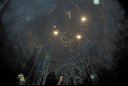
From below:
Pictured is a view up the access shaft for the Sedrun-Gotthard base tunnel. The
Gotthard base tunnel will stretch 57 kilometers through the Alps as part of a
railway improvement program in Switzerland. Photo by Herbert Einstein.
The longer of the two tunnels, the new Gotthard tunnel, will run 57 kilometers,
making it the world’s longest. The other tunnel, Lötschberg, will stretch
34.6 kilometers. Both will sit lower in the mountains than any of the many rail
tunnels or highway tunnels previously built in Switzerland. At greater depths,
slopes leading into the tunnels aren’t as steep, and heavier trains can pass
through.
The need for the new tunnels started as early as the 1960s when Europe experienced
rapid economic growth. One consequence of this growth was a highway building boom
that produced several long highway tunnels through the mountains between 1964
and 1980, some of them as long as their predecessor railway tunnels. By 1998,
the freight being transported through and across the Alps by rail and truck within
the arc between Mount Cenis (France) and Brenner (Austria) equaled about 98 million
tons, more than triple the amount 30 years earlier.
Over time, the amount of freight being carried by truck in Europe has eclipsed
the amount being carried by rail. But, in Switzerland, rail traffic had remained
dominant because the country maintained a 28-ton limit for truck freight transport.
Now, as part of several agreements with the European Union, Switzerland raised
that limit to 40 tons to match other European countries. As a result, truck traffic
through Switzerland and on transalpine roads is increasing and will continue to
increase, a trend that the Alpine countries find unacceptable. Thus, in the hopes
of alleviating truck traffic, they are building high-capacity rail links through
the Alps, links that require long, deep base tunnels: the Maurienne-Ambin tunnel
in France, the Brenner tunnel in Austria, and the Gotthard and Lötschberg
tunnels in Switzerland. The construction will also connect Switzerland into Europe’s
high-speed rail network.
Fueling the displeasure over truck traffic was the Oct. 24, 2001, accident in
the existing Gotthard Highway Tunnel. Two trucks collided, causing a fire that
smoldered for several days and closed the tunnel long enough to seriously disrupt
traffic patterns through the Alps. Eleven people died in the accident. In March
of 1999, a tunnel fire also claimed lives when a cigarette butt caused a truck
carrying flour and margarine to explode in the Mont Blanc tunnel that connects
France and Italy. Thirty-nine people died. And in May of 1999, a collision in
Austria's Tauern tunnel caused a fire that killed 12 people.
The new Gotthard and Lötschberg tunnels are part of Switzerland’s NEAT
project: Neue Eisenbahn Alpentransversalen or New Transalpine Railroad Link. The
major components of NEAT are the Gotthard and Lötschberg-Simplon axes but
with additional improvements along the access lines.The main axes parallel the
present roads and railways, but their base tunnels, Gotthard and Lötschberg,
will be deeper and longer than any of the existing tunnels and than the existing
tunnels of the same names.
The Gotthard base tunnel will be 600 meters deeper than the existing Gotthard
tunnel. The Lötschberg base tunnel will be 550 meters below the current Lötschberg
tunnel. The existing Simplon tunnel, 20 kilometers long and at an elevation of
700 meters, is a part of the new system. Several more tunnels no more than 10
kilometers long will be built to create an access system that will join the existing
tunnels with their corresponding base tunnels, creating a four-track system. The
existing tunnels can allow 250 trains per day, but the new base tunnels will increase
that capacity by 300 trains per day.
Working with geologic uncertainties
Some sections of the two tunnels may cause considerable difficulties during
construction, difficulties that translate into added cost and time. Also, even
in well explored cases like these two tunnels, it is not possible to precisely
predict what will be encountered, an uncertainty inherent to most geologic and
geotechnical projects. In addition, even if the geology were precisely known,
construction processes always include variability. Although risk analysis is
a well-known tool in business administration and has been so for a number of
decades, it is not frequently used in major infrastructure projects. For the
two transalpine tunnels, it was applied extensively not only regarding cost
and time but also regarding operational safety.
The feasibility and design stages of the project paid close attention to selecting
the most suitable tunnel alignments with respect to the geology. Important geological
criteria in this process were: avoiding tunnel sections with very high overburden
and stresses; finding the most stable ground conditions at locations of multifunction
stations; limiting the length of the tunnel sections that are in weaker rocks
(Triassic evaporates, phyllites, shists and cataclasites); optimal tunnel orientation
with respect to critical tectonic structures (shear zones, faults, foliation);
and protecting groundwater resources while minimizing the flow of groundwater
into the tunnel. In addition, other criteria, such as short total tunnel length
and short access ramps or shafts, accessibility, environmental protection and
large tunnel radii had to be considered. These factors led to final tunnel alignments
that follow good ground conditions over long tunneling intervals.
Nevertheless, geologically problematic structures or conditions could not be
entirely avoided.
Preliminary site investigations, conducted primarily between 1990 and 1999,
focused efforts on reducing, quantifying and mitigating geological uncertainties
and risks. Simon Löw and colleagues reported the results of these investigations
at the GeoEng 2000 International Conference on Geotechnical and Geological Engineering
in Melbourne. One example follows.
Water from fault zones
 It is known through
numerous tunnels and hydropower drifts built in the eastern Aar and Gotthard
massifs during the past 130 years that some of the steeply inclined fault zones
in these units are highly permeable and could lead to initial tunnel inflows
of 100 to 1,000 liters per second. As tectonic forces push the rocks against
and past each other, the rock is ground into pieces, much the way a powder forms
when two pieces of concrete scrape past each other. These cataclastic faults
create broken-down rock that is much more permeable than the original rock,
easily allowing water to pass through.
It is known through
numerous tunnels and hydropower drifts built in the eastern Aar and Gotthard
massifs during the past 130 years that some of the steeply inclined fault zones
in these units are highly permeable and could lead to initial tunnel inflows
of 100 to 1,000 liters per second. As tectonic forces push the rocks against
and past each other, the rock is ground into pieces, much the way a powder forms
when two pieces of concrete scrape past each other. These cataclastic faults
create broken-down rock that is much more permeable than the original rock,
easily allowing water to pass through.
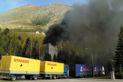
Tunnel fire:
Trucks wait in line as smoke billows from an exhaust exit of the Gotthard tunnel
near Airolo, Switzerland. On Oct. 24, 2001, two trucks collided in the tunnel,
igniting a fire that killed 11 people. The accident and others in transalpine
highway tunnels have fueled sentiment that too many trucks use the roads and
tunnels. Austria, France and Switzerland are working on large construction projects
in an effort to increase the freight capacity of their transalpine railway systems.
AP Photo/KEYSTONE, Giuliano Giulini
The mean total spacing between faults in the area of the eastern Aar and Gotthard
massifs is on the order of only 35 meters; they are very close together. But
the mean spacing between faults that would produce inflow is only every 200
meters. Therefore, only a small percentage of all faults mapped at the surface
and described in inventories of large faults are expected to be permeable at
a critical level. At the same time, predicting the location and properties of
fault zones 1,000 to 2,500 meters below ground surface — the elevation
of the tunnel — is an extremely difficult or even impossible task, but
many people are working on understanding relationships between fault mechanics
and rock permeability.
Fault zones do not only pose problems to miners during excavation, but also
to the environment. It is known from many tunnels already built in the Alps
that large tunnel inflows in crystalline rocks can draw down the water table.
Such water table drawdowns can dry out springs located many kilometers away
from the tunnel alignment. Even more spectacularly, geodetic measurements performed
in the Aar and Gotthard massifs above the existing Gotthard Highway Tunnel show
that localized tunnel drainage from just one permeable fault zone has created
surface settlements on the order of 12 centimeters over distances of many kilometers.
These settlements are unexpected because they occur in stiff crystalline rocks
above a tunnel that has an overburden of 1,000 meters. As reported in a Ph.D.
thesis by Christian Zangerl of ETH (Swiss Federal Institute of Technology) in
Zurich, model calculations show that these settlements cannot be explained purely
by closure of fractures, but that properties of the intact rock also contribute
to the observed phenomena. Strong local variations of surface settlements could
possibly cause serious damage to arch dams, which sit in nearby valleys. For
such reasons, detailed localization and characterization of critical faults
at tunnel elevation is performed with new exploration techniques carried out
from the advancing tunnel face.
Modernizing transalpine crossings
Engineers have tackled the Alps many times before. Transalpine traffic in Europe
existed in prehistoric times and it was important for the Celts and particularly
the Romans. One can state that the founding of the Swiss Confederation in the
13th century was closely related to the transportation corridor over the Gotthard
Pass. As a matter of fact, only an engineering feat — the construction
of a suspended roadway along the steep walls of the Schöllenen Gorge, and
a bridge across this gorge — made the Gotthard an acceptable route. Once
this was achieved, it benefited from being one of the shortest European North-South
routes.
This route and others across mountain passes were, in essence, mule paths. The
next major development, in the first half of the 19th century, was when roads
were built over several mountain passes, making stagecoach and wagon transportation
possible. In the second half of the 19th century and in the early 20th century,
railroad connections were built across the Alps, first without tunnels or with
only short tunnels and then, starting with the Mont Cenis tunnel, including
major tunnels.
Since then, engineers have constructed many rail and highway tunnels through
the Alps. The current project is one of the most ambitious. Changing policies,
populations and economics demand two more, and engineers and geologists are
working together to meet the challenge.
Löw is chair and professor
for engineering geology at the Swiss National Institute of Technology in Zurich
and has been involved in the planning and realization of Switzerland's railway
improvement project for the last 10 years.
Einstein is a professor of civil and environmental engineering at the Massachusetts
Institute of Technology. He and colleagues at MIT and in Switzerland developed
and applied a decision analysis tool to estimate construction cost and time of
the Gotthard- and Lötschberg base tunnels. E-mail him at: Einstein@mit.edu.
