
 The invitation
came by e-mail. David Wunsch, State Geologist and Director of the New Hampshire
Geological Survey, had learned that there would be space in a sno-cat for him
and a guest to ride to the Mount Washington Observatory. Would someone from
Geotimes like to accompany him? This would mean spending the night inside the
observatory responsible for monitoring some of the world’s worst weather
as it blows across New Hampshire’s Presidential Mountain range. Since 1849,
those mountains have claimed 124 lives, including four hikers who would die
later that year, one of natural causes, one of hypothermia and two from an avalanche.
The invitation
came by e-mail. David Wunsch, State Geologist and Director of the New Hampshire
Geological Survey, had learned that there would be space in a sno-cat for him
and a guest to ride to the Mount Washington Observatory. Would someone from
Geotimes like to accompany him? This would mean spending the night inside the
observatory responsible for monitoring some of the world’s worst weather
as it blows across New Hampshire’s Presidential Mountain range. Since 1849,
those mountains have claimed 124 lives, including four hikers who would die
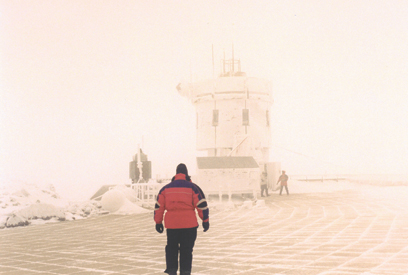
later that year, one of natural causes, one of hypothermia and two from an avalanche.Dave Wunsch carefully makes his way along the weather deck above the Sherman Adams Building. Photo by Christina Reed.
Two weeks later, I was on a plane to New Hampshire. The following morning Wunsch and I met the sno-cat driver, Chris Uggerholt, and a couple of volunteer weather observers at the eastern base of Mount Washington. The observers and Uggerholt looked Wunsch and me over, making sure we each wore appropriate wool and/or synthetic (not cotton!) clothing for the journey along with insulated gloves, goggles and mountaineering boots. We kept our crampons for our boots handy in case we needed to abandon our snow vehicle and hike out. The twin-tracked machine, equipped with a plow and back cabin, was made to haul about 10 passengers and their gear. Its primary route: the 8-mile-long, privately owned Auto Road from the mountain’s eastern base to the observatory stationed at 6,267 feet high in elevation, only 21 feet below the peak. Uggerholt secured our backpacks and sleeping bags to the roof of the sno-cat.
I had visited the observatory once before, 17 years ago, during a month when the average temperature hovered around 40 degrees Fahrenheit and the Cog Railway took tourists straight up the western side of the mountain. From October through April the temperature averages below freezing. By mid-November the Cog’s “Little Engine that Could” cannot, and car traffic up the Auto Road along the eastern slope yields to the sno-cat. When weather permits, skilled mountaineers can hike mapped trails marked occasionally with rocky cairns in the White Mountain National Forest, but the observatory is off limits for their use. Teachers and members of the observatory can ride the sno-cat to the summit and spend the night at the observatory as part of its education trips, or EduTrips. These overnight sojourns offer visitors a chance to learn firsthand the challenges of recording winter weather at the observatory.
With records of hurricane-strength winds (74 miles per hour) occurring on average 104 days of the year and freezing fog occurring almost daily in the winter, Mount Washington has a reputation for being “Home of the world’s worst weather.” Every hour someone on the mountain is recording temperature, barometric pressure, visibility, prevailing conditions, sky cover and relative humidity. They do this in 12-hour shifts that begin and end at 4:30. Even with hourly reports however, and more than 70 years of records, the worst weather in the world is still surprising. Indeed meteorologists planning to travel to Antarctica have spent shifts on Mount Washington in preparation for their trip.
 As the only mountain
in the northeast taller than 6,000 feet, Mount Washington sits like a traffic
control tower monitoring the weather fronts that move across the New England
portion of the Appalachians. The jet stream from the west controls the path
of high and low pressure systems across the country. Low pressure systems bring
in the storms. At Mount Washington, high winds traveling from the St. Lawrence
and Ohio valleys and up along the Atlantic coast collide in a small atmospheric
window over the summit. The bottom of this window is the summit and the top
is the tropopause.
As the only mountain
in the northeast taller than 6,000 feet, Mount Washington sits like a traffic
control tower monitoring the weather fronts that move across the New England
portion of the Appalachians. The jet stream from the west controls the path
of high and low pressure systems across the country. Low pressure systems bring
in the storms. At Mount Washington, high winds traveling from the St. Lawrence
and Ohio valleys and up along the Atlantic coast collide in a small atmospheric
window over the summit. The bottom of this window is the summit and the top
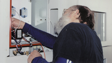
is the tropopause. Dick Bailey adjusts the weather instruments that record the anemometer’s wind speed. Photo by Christina Reed.
In the winter, cooler temperatures create less warm-air convection to buoy the tropopause up, the region of air that separates the weather-producing troposphere from the stratosphere. When the tropopause falls, the area of the troposphere between the summit and the tropopause shrinks, but the volume of air passing through it is the same. The funnel-like condition of a low tropopause causes the winds to cross the summit even faster than usual, often with speeds exceeding 100 miles per hour. The world record for the fastest wind speed at a surface station still stands at 231 miles an hour, observed at the summit of Mount Washington on April 12, 1934.
The U.S. Signal Service, a precursor of the Weather Bureau, first provided regular meteorological observations on Mount Washington from 1870 to 1892. The example of a continuous observing station led other countries to follow suit. “In the early days of the observatory they didn’t know what the conditions were like on a mountain. It was a basic inquiry weather-wise, but no one could answer it. So they sent up four people to document what was going on,” says Ken Rancourt director of research at the observatory. “They found it inhospitable and a challenge to record weather on a regular basis.”
After World War I, with advances in aviation and shortwave radio, the scientific contribution an observatory on Mount Washington might offer came back into demand. Observers reoccupied the summit in 1932. Much of the research at the time focused on the formation of rime ice. In the winter, rime ice forms on everything exposed, as supercooled water droplets carried in the clouds freeze immediately upon impact with whatever they touch, including another frozen water droplet. The formation of rime ice creates a strange illusion of ice flags waving in the wrong direction, for it builds up into the wind and is deceptively strong. Today, every hour the observers climb to the top of the parapet and bang a metal rod against the ice to clear the anemometer and other instruments of their frozen burden. The same ice forms on airplane wings and many of the de-icing methods used now come from research conducted on Mount Washington.
 “We still
do some studies on the supercooled large droplet [rime ice] problem. But major
efforts today are on air-quality measurements and continual weather observations,”
Rancourt says. “We need to know long-term weather measurements before we
can make any evaluation with what’s happening to climate change. Our record
began in 1932; that’s 70 years in one location.”
“We still
do some studies on the supercooled large droplet [rime ice] problem. But major
efforts today are on air-quality measurements and continual weather observations,”
Rancourt says. “We need to know long-term weather measurements before we
can make any evaluation with what’s happening to climate change. Our record
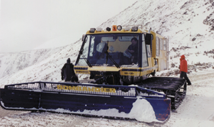
began in 1932; that’s 70 years in one location.” Conditions along the Auto Road allow Chris Uggerholt to stop the Bombadier sno-cat for a quick break. Photo by Christina Reed.
The morning of our arrival at the base, the summit had received 7 inches of new snow in the last two days. With 100 mile-per-hour winds, the snow drifts on the Auto Road had reached 15 feet in some areas. Uggerholt carefully threaded his way up the road, stopping multiple times to back up and attack the drift in front of him again in order to level it enough to cross. The sno-cat doesn’t need to plow the entire road but it needs to travel across level snow or the sleds that give it traction uphill will slide off the mountain’s incline. Uggerholt has 12 years of experience shuttling meteorologists and visitors to the observatory and never loses his respect for the mountain. “It can be a scary place sometimes,” he says. “A lot of times I can’t see what I’m doing and there is not a lot of room for error.” Even though the road is only 8 miles long, cruising speed for the sno-cat is 8 miles per hour and with stops and starts to level the road the trip takes usually 90 minutes. It took us two hours.
Soon after arriving at camp, I followed a volunteer researcher, Ann Grote, outside to watch her test whether the snow outside was falling or just blowing around. From the weather station, I climbed the spiral stairs to the observation deck on the roof, where gusts blew up to 88 miles per hour. Grote held up a blackboard and explained that fresh falling snow explodes on impact, but blowing old snow bounces due to different crystal structures.
Later, Wunsch and I went out on the observatory deck to test our skills at walking in 100 mile-per-hour winds. We slowly worked our way to where we faced the brunt of the wind without shelter and dropped to our knees to keep from stumbling. Once on our knees, we raised our arms and leaned into the wind. We could get to about a 45 degree angle to the stone-tiled roof deck before the wind would calm a bit and we would end up doing push-ups to keep from face-planting onto the deck.
After a dinner of homemade spinach and cheese calzones, I followed another volunteer researcher, Katie Koster, to watch her switch the metal tubes they use to measure precipitation. The crampons on our boots kept us from sliding in the 88 mile-per-hour winds. Koster hauled out a heavy metal tube almost as big as she was, and swapped it for the snow-filled tube. Once inside the weather station, she measured the water content of the snow that had either fallen or blown into the tube. The observatory is testing different precipitation gauges to evaluate a newer model’s potential benefit to the airline industry before it goes into commercial production.
The next morning, Uggerholt met us with the new shift of visitors attending an EduTrip to the summit. Wunsch and I agreed that our trip provided a fantastic opportunity to learn first-hand about weather instrumentation and the efforts it takes to manually record weather conditions. Before he became a geologist, Wunsch had studied meteorology in college. The combination of skills gave him a keen perspective on Mount Washington. “It was interesting to witness some of the geologic phenomena related to cold weather,” he says. “The whole top of Mount Washington is felsenmeer, an old German term for a ‘sea of rocks.’” Instead of the red Conway granite, which hosts the Old Man of the Mountain profile seen on 2001 New Hampshire quarters, Mount Washington has a mismatch of metamorphic rock. “Above tree level there is little life and a quick trip to Mount Washington makes it is easy to envision what it would be like in New Hampshire 12,000 years ago when glaciers were here year-round.” Blowing snow, freezing fog, and boulders covered with rime ice make for a hostile environment; the best place to study bad weather — and good weather too, once it changes.
