
 So far, the group
has recovered more than 95 percent of the data in real time and the latency
— the difference between when the sensors record the GPS data and when
researchers actually receive data — is less than one second.
So far, the group
has recovered more than 95 percent of the data in real time and the latency
— the difference between when the sensors record the GPS data and when
researchers actually receive data — is less than one second. At this locked section of the fault, geophysicists say they actually are moving a step closer to creating a reliable early warning system for earthquakes that combines GPS fault-slip sensors with seismic sensors.
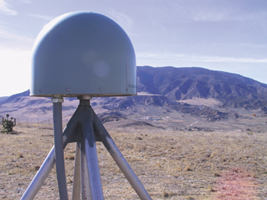
GPS monument, complete with antenna and a gray hemi-spherical radome cover, for the Southern California Integrated GPS Network (SCIGN) site at Lone Juniper Ranch marks where sensors are measuring slip along the northeast side of the San Andreas fault near Gorman, Calif. In the background lies another SCIGN site at Frazier Mountain High School, on the other side of the San Andreas. Photo courtesy of USGS.
“The GPS sensors would act like a large creep meter and measure the particle motions of the sites in a way that complements the seismic sensors,” says geophysicist Ken Hudnut of the U.S. Geological Survey in Pasadena.
GPS sensors are best at measuring large motions at low frequencies, and seismic sensors are best at measuring small motions at high frequencies. “Putting the seismological part together with the global positioning part, you get a very good idea of what the motion of the Earth is over a wide range of frequencies,” says Tom Heaton, a professor of engineering seismology at the California Institute of Technology. Neither system alone can give an entire view, he says. The combination of the two technologies will allow for early warnings (on the order of seconds) that are robust and reliable.
J.D. Cooper proposed the idea of early warning in a Nov. 3 1868 editorial in the San Francisco Daily Evening Bulletin: “A very simple mechanical contrivance can be arranged at various points from 10 to 100 miles from San Francisco, by which a wave of the earth high enough to do damage will start an electric current over the wires now radiating from this city and almost instantaneously ring an alarm bell, which should be hung in a high tower near the center of the city.” Though simple in concept, this idea has taken years to even come close to reality.
 The management of
such an early warning system is fraught with questions — such as, how much
warning is enough warning to save lives and property, or what happens when an
earthquake occurs directly below an urban center? But the system holds great
promise beyond warning people by allowing, for example, for the automatic shutdown
of oil pipelines as happened this past November with the magnitude-7.9 earthquake
on the Denali fault in Alaska. A coupling of GPS and seismic sensors could more
quickly distinguish the size of a quake and rapidly make a decision whether
or not to shut off critical services.
The management of
such an early warning system is fraught with questions — such as, how much
warning is enough warning to save lives and property, or what happens when an
earthquake occurs directly below an urban center? But the system holds great
promise beyond warning people by allowing, for example, for the automatic shutdown
of oil pipelines as happened this past November with the magnitude-7.9 earthquake
on the Denali fault in Alaska. A coupling of GPS and seismic sensors could more
quickly distinguish the size of a quake and rapidly make a decision whether
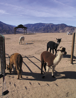
or not to shut off critical services.Alpaca roam freely at the Lone Juniper Ranch, a site along the San Andreas fault for the Southern California Integrated GPS Network. Photo courtesy of USGS.
That’s because, Hudnut says, GPS sensors are extremely sensitive to actual slip on the fault. “The seismic sensors start to pick up shaking in the first few seconds, but it’s still difficult for them to distinguish between whether this is going to be a large event or just remain a small event. The GPS sensors can start detecting actual slip on the fault plane and, at that early stage, can help to discriminate between a large event and a small event.”
Slip at the ground surface of more than 5 centimeters on a previously locked fault likely signals an earthquake of magnitude 6.0 or higher, Hudnut says. “And we can detect that slip with a GPS system probably within less than 10 seconds.” At that point, the seismic sensor data, he explains, still may not be able to distinguish whether or not the earthquake is destined to become a “Big One” — important information for deciding whether to shutdown key utility or public infrastructure systems.
Beyond early warning, Hudnut says, GPS real-time fault slip hold value in rapidly gaining information on how much slip has occurred at points along a fault, especially where critical lifelines, such as highways and bridges cross faults — rather than having to wait for field personnel to make on-site measurements.
This winter, following on the success of their GPS deployment, Hudnut and his team of USGS researchers plan to deploy a strong motion seismic sensor package hooked up to GPS — continuing their pursuit of early warning.
