
 Researchers
have gathered together a broad network of GPS data to draw a map of microplates
in the Aegean. The data fit a simpler model than expected, and the results,
they say, imply that larger continental plates may be composed of microplates
too.
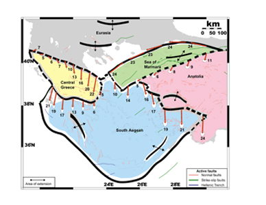
Researchers
have gathered together a broad network of GPS data to draw a map of microplates
in the Aegean. The data fit a simpler model than expected, and the results,
they say, imply that larger continental plates may be composed of microplates
too. From left to right, the recently identified Aegean microplates: Central Greece (yellow), South Aegean (blue), Sea of Marmara (green) and Anatolia (pink). Image courtesy of Wayne Thatcher, USGS.
Marlene Nyst and Wayne Thatcher of the U.S. Geological Survey compiled six European datasets of GPS measurements in Greece, Turkey and the Peloponnese peninsula. The researchers calibrated the smaller sets to one large set, orienting them together. The GPS measurements were translated into velocity vectors, showing directions and speeds of surface movements for the region. The measured crustal movements lined up to show some areas moving together, but also showed four distinct corridors with relatively higher amounts of crustal deformation. These crumpling zones represent boundaries for four microplates: Central Greece, South Marmara, Anatolia and the South Aegean.
Thatcher presented the new model at the American Geophysical Union meeting last December (their paper is in press for the Journal of Geophysical Research. Past models have suggested two or three microplates and discrete bands of squashing that look like stripes on a map, in a region shaped by the collision of Africa, Eurasia and Anatolia. Scaling up the Aegean system, Thatcher says, implies that the larger continents also may be composed of smaller plates - rather than single giant rigid plates with regions of diffused deformation (the accepted model at present), where the crust crumples and buckles broadly.
Tanya Atwater, of the University of California, Santa Barbara, says the distributed GPS surveys have "taken us to a whole new level in being able to think of continental deformations," instead of having to wait for hundreds of years of earthquakes to locate boundaries.
William Holt of Stony Brook University in New York says "the one shortcoming of their model is that it fails to predict the seismicity distribution within the blocks." Although the researchers' model fits the crustal motions, Holt says, many more microplates probably are present in the Aegean - possibly more than a dozen. He says GPS may be "too blunt of a tool" to precisely locate all microplate boundaries.
Naomi Lubick
Back to top
