Geotimes

Feature
Geoarchaeology:
The Past Comes to Light
Geotimes Staff
Perhaps the only way to fully understand early humans is to understand their
ancient environments. That simple concept underlies the field of geoarchaeology — the application of the earth sciences to archaeological studies. The following
geoarchaeology vignettes show that geological stories are inseparable from the
human ones: Sea level can rise causing populations to migrate. A volcano can
erupt and wipe out a civilization. Climate can alter the soil and shift the
course of a culture. As the natural world changes, so too does society. Together,
geologists and archaeologists can unravel our past and better plan for and understand
our future.
Searching Dirt
Aegean Volcanic Dating Dilemma
Digging Below Manhattan
Black Sea Floods
Satellites Reconstruct Ancient Egypt
Iceman's Origins
SEARCHING
DIRT
 For
25 years, geologist Rolfe Mandel has been studying early Americans. He wants
to know when they first arrived on the continent, where they came from and where
they went once they populated the landscape. But in searching for clues from
ancient people, Mandel decided on a route different from most archaeologists.
They go out looking for artifacts; he goes out looking for soils.
For
25 years, geologist Rolfe Mandel has been studying early Americans. He wants
to know when they first arrived on the continent, where they came from and where
they went once they populated the landscape. But in searching for clues from
ancient people, Mandel decided on a route different from most archaeologists.
They go out looking for artifacts; he goes out looking for soils.
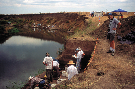
Excavations in 2003 at the Claussen
site along Mill Creek in northeast Kansas revealed at least three archeaological
horizons. Rolfe Mandel, shown below inspecting mussel shells in an ancient campsite
buried 30 feet deep, now awaits radiocarbon dates for the lower two horizons.
Images courtesy of John Charlton, Kansas Geological Survey.
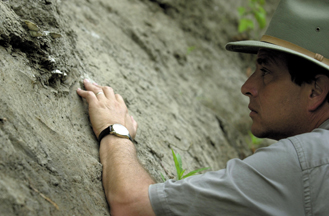 Mandel
diligently treks from creekbed to creekbed, searching the banks for layers of
soils that might be more than 9,000 years old, in hopes of finding evidence
of early Americans. He believes that Paleo-Indians spent most of their time
in stream valleys and near shallow depressions known as playas. As focal points
for water, animal and plant resources, the playas and streams were attractive
to people living in the High Plains. Because buried soils are viewable in river
cutbanks, Mandel says, the banks are like windows to ancient landscapes.
Mandel
diligently treks from creekbed to creekbed, searching the banks for layers of
soils that might be more than 9,000 years old, in hopes of finding evidence
of early Americans. He believes that Paleo-Indians spent most of their time
in stream valleys and near shallow depressions known as playas. As focal points
for water, animal and plant resources, the playas and streams were attractive
to people living in the High Plains. Because buried soils are viewable in river
cutbanks, Mandel says, the banks are like windows to ancient landscapes.
Ancient Americans are among the most elusive groups for archaeologists to study
because they were largely nomadic, following migrating herds of bison. They
left little behind in the way of belongings or settlements, Mandel says. So
archaeologists look for subtle clues of habitation, including flint spear points,
knife blades, charcoal remains of campfires and bone fragments from the game
that provided sustenance for the Paleo-Indians.
Until recently, most anthropologists believed that the peopling of North America
began about 11,500 years ago with the crossing of the Beringia land bridge and
then slow migration across the continent. However, archaeologists have now found
sites dating human activity to at least that age in the North American Southwest
and Southeast, which leads some researchers to believe that people arrived well
before then (see stories in this issue).
Mandel and colleagues at the University of Kansas department of anthropology
and the Kansas Geological Survey believe they will find evidence of inhabitants
from more than 11,500 years ago across the Great Plains. Art Bettis, a geologist
at the University of Iowa who also studies the peopling of the Great Plains,
says it is "very likely" that geoarchaeologists will find these older
sites.
Mandel, Bettis says, has developed the first comprehensive description of the
Quaternary landscape history of Kansas, which will help in the search for buried
archaeological sites. Indeed, Mandel's work is one of the most detailed regional
histories of Holocene environments in the world, echoes Lee Allison, head of
the Kansas Geological Survey. Having a good idea of what the ancient landscape
looked like, especially the temporal and spatial patterns of soil deposits,
allows Mandel to then target these geological oases for potential archaeological
evidence. "It is geologic exploration applied to an entirely new field,"
Allison says. Thus far, searching the soils has led Mandel and colleagues to
uncover several Paleo-Indian sites in Kansas that are at least 9,000 years old.
"Each site fills in a slightly different piece of the puzzle," Mandel
says. At the Kanorado site in northwestern Kansas, for example, researchers
uncovered well-preserved mammoth and camel bones at the base of a river cutbank
— thought to be more than 11,000 years old. And at the Winger site in southwestern
Kansas, researchers saw a massive bison bone-bed about 9 feet below the surface
along a stream that is cutting into a playa. Researchers have dated the bones
to about 9,000 years ago, and Mandel says there may be additional, older layers
below.
One spot to watch, Bettis says, is the Claussen site in northeastern Kansas,
which Mandel first discovered in 1999 but only recently began fully exploring.
Walking along a creekbed, 30 feet below the present-day land surface, Mandel
saw telltale signs of former stable landscapes — dark soil layers that
indicate buried topsoils. In the dark layers, he noted small flakes of flint,
cracked and blackened rocks from ancient fires, mussel shells and animal bone
fragments. At the very least, Mandel says, "someone had eaten dinner here
thousands of years ago." Even more exciting, he says, was that he could
see at least three distinct layers of human activity, with the upper layer dated
to nearly 9,000 years ago.
In the summer of 2003, Mandel and a team of archaeologists returned to the site,
armed with a $1 million endowment from retired geologist Joe Cramer (who has
spent more than a few years in search of ancient Americans himself) to search
for further evidence of human activity. They collected charcoal samples from
each distinct layer and sent them to a lab for radiocarbon dating. Now, Mandel
awaits word on the dating. In the meantime, he's going back out to the streambeds,
looking for archaeological evidence in the soils.
"Mandel's research into the early Americans promises to increase immensely
our understanding about the peopling of the Plains," Bettis says. Mandel
has changed the field of archaeology, he says, and it will be exciting to see
what comes next.
Megan Sever
Links:
"The
Ice-Free Corridor Revisited," Lionel E. Jackson Jr. and Michael C.
Wilson, Geotimes, February 2004
"Quest
for the Lost Land," Renée Hetherington et al., Geotimes,
February 2004
Back to top
Aegean
Volcanic Dating Dilemma
 After a volcanic
eruption, widespread ash plumes can smother the region and leave behind valuable
marker horizons in the archaeological record. By assigning absolute dates to these
horizons, geologists are working with archaeologists to better understand the
history of the ancient civilizations that flourished nearby. At Thera, an eastern
Mediterranean island also known as Santorini, geologists are looking to the ash
to reconstruct what happened there thousands of years ago.
After a volcanic
eruption, widespread ash plumes can smother the region and leave behind valuable
marker horizons in the archaeological record. By assigning absolute dates to these
horizons, geologists are working with archaeologists to better understand the
history of the ancient civilizations that flourished nearby. At Thera, an eastern
Mediterranean island also known as Santorini, geologists are looking to the ash
to reconstruct what happened there thousands of years ago.
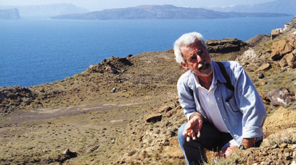
Floyd McCoy samples a small remnant of a
massively thick deposit left behind by the Late Bronze Age eruption of Thera in
the eastern Mediterranean. In the background stands the huge caldera excavated
by that eruption and now filled by the sea. Photo courtesy of Floyd McCoy.
Thera erupted more than 3,500 years ago, causing pyroclastic flows, earthquakes,
tsunamis and extensive tephra plumes that scattered pumice and ash as far away
as the Black Sea and the Nile Delta. In 1939, Greek archaeologist Spyridon Marinatos
hypothesized that the Late Bronze Age eruption had led to the demise of the artistically
and technologically advanced Minoan civilization, which had thrived for more than
1,500 years on the Aegean island of Crete, just 70 kilometers south of Thera;
the civilization began to decline in 1450 BC. This idea quickly gained widespread
acceptance and was later popularized as proof of the historical accuracy of the
myth of Atlantis. However, a discrepancy between archaeological and geological
findings has led to a 20-year-long debate about the exact date of the eruption
and therefore, its role, if any, in the collapse of the Minoan civilization.
Traditional archaeological techniques of dating — such as synchronization with
Egyptian civilizations through the discovery of Minoan pottery at sites in the
Nile Valley or of Egyptian artifacts on Crete — have put the eruption date around
1550 B.C. or later. And some radiocarbon dates from the town of Akrotiri, a Theran
city buried under meters of ash, place it closer to 1500 B.C.
Other geological dating techniques have suggested a much earlier date for the
eruption. Acid snow and volcanic glass found in Greenland ice cores place the
date of the eruption around 1645 B.C. Also, thicker than normal tree rings found
in ancient trees in Anatolia show that a cool wet year, possibly caused by a massive
volcanic eruption, occurred around the same time. Additional evidence for climate
change at this time comes from Ireland, California and China.
"It's really geophysicists against archaeologists," says Floyd McCoy,
a volcanologist at the University of Hawaii who has been studying Thera for more
than 20 years. "But it's not a hostile thing. It's a wonderful kind of conversation
going on as we try to figure this out."
McCoy recently discovered 2-meterthick ash deposits in new roadcuts on the island
of Anaphi, 12 kilometers east of Santorini, and ash in seafloor cores close to
the Peloponnese peninsula. Both findings indicate a much wider ash distribution.
"This eruption was almost 10 times bigger than we thought," McCoy says.
"It had been about a 6. This puts it at 7.0" on the Volcanic Explosivity
Index, which ranges from 0 to 8. It would thus have had a more damaging and lasting
effect on the region's agriculture, trade, infrastructure and fleets, he says,
which could have eventually contributed to the Minoan collapse. "It's my
opinion that this eruption changed the whole course of Western civilization,"
McCoy says.
Jeremy Rutter, a specialist in Bronze Age archaeology of the Aegean at Dartmouth
College, agrees with the earlier date for the eruption, but he says that even
if the eruption were more explosive, the time span between the eruption and the
collapse of Minoan palatial civilization is still too long for it to be a factor.
"There's no way you're going to make something that happened in either 1640
B.C. or 1550 B.C. responsible for something that happened quite suddenly in 1450
B.C.," he says.
The true importance of the eruption date, Rutter says, is its potential for use
in correlating developments within various Bronze Age civilizations across the
eastern Mediterranean. "This is a problem that has been haunting this small
corner of scholarship for some time now," he says. "We're interested
in determining whether certain things happened first in Egypt or first in the
Aegean. And continuing disagreement over the absolute date of the Theran eruption
really is getting in the way of making progress on this."
Rutter said he expects the conflict will be resolved in the next 10 to 15 years,
with the discovery of Theran ash in a welldated archaeological site in the Near
East or by advances in dendrochronology. Or it could be solved geologically, McCoy
says. He is currently trying to apply new techniques for dating the eruption itself.
Sara Pratt
Geotimes contributing writer
Back to top
Digging
Below Manhattan
 Buried under
the cement and concrete of the Manhattan skyline lie layers of glacial deposits,
animal bones and modern human detritus, representing thousands of years of Holocene
geology. The most urban setting in the world still provides opportunities for
geoarchaeological research, and recent work on the soils and stratigraphy of the
island sheds light on how to dig in New York.
Buried under
the cement and concrete of the Manhattan skyline lie layers of glacial deposits,
animal bones and modern human detritus, representing thousands of years of Holocene
geology. The most urban setting in the world still provides opportunities for
geoarchaeological research, and recent work on the soils and stratigraphy of the
island sheds light on how to dig in New York.
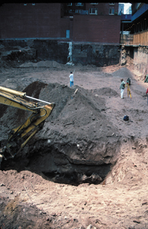
A trench at a dig site on Worth St. in downtown
Manhattan reveals soils and other geologic evidence for the ancient and more recent
history of New York. Image courtesy of Geoarcheology Research Associates.
Joseph Schuldenrein and his team of geoarchaeologists have further elucidated
Manhattan's geology, both prehistoric and historic. In the past few years, the
researchers were called in to several construction projects where they had a rare
opportunity to core and document profiles from freshly dug sites across lower
Manhattan.
They had seen these neighborhoods before, when centuries-old African-American
burial grounds were discovered during the construction of a tunnel almost two
decades ago. Schuldenrein, an adjunct professor at New York University, established
Geoarcheology Research Associates in 1989. Based in Riverdale, N.Y., the consulting
geoarchaeologists determine whether construction projects will disturb historic
sites and document the value of what might be found, necessary steps under the
National Historic Preservation Act. The company works to fuse geology and archaeology,
studying everything from early Native American landscapes in the Ohio River valley
to early cultures in Pakistan, India, and Jordan.
During their most recent opportunities to see under the city, the researchers
recorded some known stratigraphic history — from late Quaternary glacial moraine
deposits and prograding deltas to the arrival of the Dutch and the beginning of
anthropogenic landscape shifts. But they also found a soil horizon they could
follow across the island.
"Nobody knew about this soil," Schuldenrein says. The stable landform
serves as a baseline for future digging, allowing the team to reconstruct the
island's past surface morphology. It also provides a date for stratigraphic reference
from the layer's organic material, of about 2,000 years before present. Schuldenrein
presented the new soil horizon and a complete history of the island at last year's
annual Geological Society of America (GSA) meeting in Seattle, Wash.
Superimposing historic and current maps with well profiles, Schuldenrein's team
has painted "a real picture" of what to expect when digging, Schuldenrein
says. The least likely traces to be encountered are Native American, which Schuldenrein
compares to "looking for a needle in a haystack — they didn't leave much
behind." However, by reconstructing the postglacial landscape, he can point
to the stream deposits that represent landscapes where people might have made
camps or hunted in the region before the Dutch settlers came.
According to Dutch maps from the 1600s, a pond sat just north of the city's first
commons, where City Hall sits today, Schuldenrein says. Native Americans probably
stayed there, and the area held a local lime source from natural springs as well.
Several hundred years later, early American tanners used both the pond and the
lime.
"As the tanning industry got bigger and bigger, the pond became a huge cesspool,"
Schuldenrein says, creating a health epidemic (and a typhus reservoir). In 1815,
the city mandated its closure, filling it without leaving a trace. But Schuldenrein
traced the origins of the fill to an early artist's rendition of a nearby hill
that was once popular for sledding in the city. "The only thing this can
be is a glacial kame," or ridge deposited by a glacial stream, says Schuldenrein,
who has found oral accounts from 1850 describing the recreation area. "In
1815, that's what they used to fill it — they just leveled the landscape."
The new New Yorkers flattened glacial features and extended Manhattan to its current
configuration, changing the terminal moraine in order to create a huge commercial
center. Geoarcheology Research Associates has produced a 15,000-year chronology
and a map of lower Manhattan, noting the potential Dutch, English and American
archaeological sites and places where, hypothetically, Native Americans could
have settled.
Schuldenrein "mentally stripped away the construction and got to the landscape
as it was when people first settled there … defining some of the glacial
features underneath the city that influenced the settlement of the earliest European
historic populations," says David Cremeens, a soil scientist with GAI Consultants,
in Monroeville, Penn., and the chair of the archaeological geology division of
GSA.
Construction of the modern city disturbed previous deposits in some places and
preserved them under cement in others, also making the evidence hard to access,
Cremeens says. Schuldenrein's work could uncover social structures or other elements
buried underneath the modern city. It "has the potential of turning up something
brand new," he says, "or at least adding to what we know."
Naomi Lubick
Back to top
BLACK
SEA FLOODS
 Born in Odessa,
Ukraine, Valentina Yanko-Hombach has always wanted to understand the ancient history
of the great basin that borders her homeland. The Black Sea, which stands as an
important trading and commercial center for the surrounding countries, holds clues
deep in its sediments about the people who once lived along its shores.
Born in Odessa,
Ukraine, Valentina Yanko-Hombach has always wanted to understand the ancient history
of the great basin that borders her homeland. The Black Sea, which stands as an
important trading and commercial center for the surrounding countries, holds clues
deep in its sediments about the people who once lived along its shores.
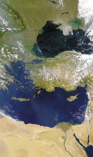
This SeaWiFS satellite pass over Turkey
in August 2000 highlights the Black Sea (top) and the nearby Mediterranean Sea.
A body of evidence is now emerging from Eastern European scientists about the
flooding history of the Black Sea, challenging a mainstream hypothesis of a large,
catastrophic flood linked to the biblical story of Noah’s flood. Provided
by ORBIMAGE and the SeaWiFS Project, NASA/Goddard Space Flight Center.
For the past 30 years, the geologist and micropaleontologist has been working
to reconstruct the region's sea level, drawing on research from other former-Soviet
and Eastern Bloc scientists. Language and political barriers have largely prevented
these scientists' data from entering the mainstream global scientific debate.
A prevailing Western idea about a past ancient flood in the region, first presented
in 1997 by Walter Pitman and Bill Ryan both of Columbia University, suggests that
salty Mediterranean water abruptly flooded the freshwater Black Sea about 7,200
years ago; the researchers link the event to the biblical story of Noah's flood.
But Yanko-Hombach is weaving together a different story for the basin — not
one of a single sharp cataclysmic inundation but instead of natural cyclicity.
The ups and downs of the sea could have mirrored the changes in culture for a
variety of societies.
She and colleagues have studied thousands of kilometers of high-resolution seismic
profiles and thousands of sediment cores during large-scale geological surveys
of the Black Sea shelf. Yanko-Hombach's own work hones in on foraminifera — shells
of bottom-dwelling microorganisms that reflect past water chemistry. She can match
specific species, for example, to the salinity signatures from various bodies
of water; some love saltwater, others abhor salt.
Yanko-Hombach's analyses suggest that the region has experienced many floods of
various magnitudes over the past 800,000 years. She has found a first wave of
recolonization by Mediterranean immigrants among foraminifera species in Black
Sea sediments as early as 9,500 years before present. Strontium isotope ratios
in mollusk shells, however, as measured by Candace Major and Steve Goldstein in
Ryan's research group, are now revealing the sudden switching on of a strong marine
signal at 8,400 years before present. Thus, Yanko-Hombach's data suggest an earlier
and less dramatic sea-level change. The evidence shows, Yanko-Hombach says, that
"Noah's flood legend has nothing to do with the Black Sea."
Ryan and Pitman's hypothesis was based on incomplete data, she says. The Black
Sea has many areas of regional washout, where sediments of certain ages are absent
and can give the impression of a flood event. Eastern scientists, however, have
long been sampling areas closer to the seashore.
Jim Teller of the University of Manitoba says that where researchers sample can
result in significantly different conclusions about changes the fossils underwent.
"Researchers get a limited number of dates, and there's a lot of difference
in the extrapolation process over intervals without dates," he says.
But Ryan speculates that the discrepancy with the Russian and Ukrainian measurements
may lie in the dating method itself. The ages Yanko-Hombach uses are primarily
derived from methods of carbon-14 dating. This technique required large samples,
he says, which may have introduced mixed organic materials and skewed the results
to older apparent ages.
"Her timing of the saltwater intrusion is more than a thousand years before
any similar salinity signal in cores calibrated with the new accelerator mass
spectrometer instruments," Ryan says. "So it is difficult for me to
see how so many salt-tolerant species of clear Mediterranean genesis could colonize
the Black Sea 9,500 years ago and yet not show up in the strontium isotopic signal."
Yanko-Hombach's data are "both wonderful and problematic," Ryan says,
pointing out that her "marvelously detailed record of the foraminifera species
abundances" still indicates the occurrence of an abrupt change in fauna in
some cores, just like what he sees in the bottom-dwelling mollusks. "A flood
from the Mediterranean could produce this change, but the real issue is whether
a flood is the required causative event or if something of less magnitude and
more gradual could produce the changes we both observe," he says.
Currently, Yanko-Hombach and Ryan are working together to apply modern dating
methods to single specimens in an old Ukrainian core sample. Ryan says that his
research has involved frequent correspondence with Eastern scientists. Yanko-Hombach's work, he says, is a valuable service to the community in creating new
opportunities for collaborative study.
"I am trying to bring together people to develop scientific dialogue,"
Yanko-Hombach says. She has already presented her research widely, including at
a NATO workshop last October in Bucharest, Romania, and the Geological Society
of America (GSA) meeting last November in Seattle, where she co-chaired a session
about the Black Sea.
To further break down barriers of the past, she has proposed a 4.5 million Euro
proposal to the European Union that involves archaeologists, anthropologists and
geologists from 11 countries, including Germany, Switzerland, France, Italy and
those bordering the Black Sea basin (excluding Georgia). The project would continue
her quest to link climate to changes in coastal migration and culture in the region.
In the meantime, archaeologists continue their own quest to link their findings
to flood events. Archaeological evidence from a site called Kamennaya Balka in
Rostov, Russia, for example, supports a large flooding event 16,000 and 14,000
years before present, Yanko-Hombach says. She and Andrey Tchepalyga of the Institute
of Geography in Moscow say that melting glaciers and thawing permafrost caused
the Caspian Sea to increase its surface level by about 80 meters, swelling to
half again its present size, and to spill multiple times into the Black Sea during
the 2,000-year period.
Nataly Leonova at Moscow State University suggests that such flooding may have
been responsible for local changes in culture about 16,000 years ago. Before that
time, Leonova says that archaeological artifacts in and around the Crimea indicate
a clear relationship to Caucasus cultures. And then that connection suddenly stopped:
The area was perhaps covered by water, cutting off communication.
All the floods likely caused some change in culture, Yanko-Hombach says. Flooding
can happen in many places in the world as a result of climate change, and thousands
of years ago, "local people would have considered this as 'Noah's flood,'"
she says.
"These were magical kinds of things, so anything truly larger compared to
your experiences and what your ancestors had told you about would be worth writing
down," says Teller, who also co-chaired the GSA session. He has published
work in 2000 suggesting that Noah's flood occurred in the Persian Gulf, where
archaeologists found the Epic of Gilgamesh — clay tablets that include a story
of a great flood.
Still, Teller says that linking any flood event to Noah's flood is nearly impossible
at this time "unless something is discovered that nails down the whole concept
of Noah's flood — which is just a few verses in the Bible."
Lisa M. Pinsker
Back to top
Satellites
Reconstruct Ancient Egypt
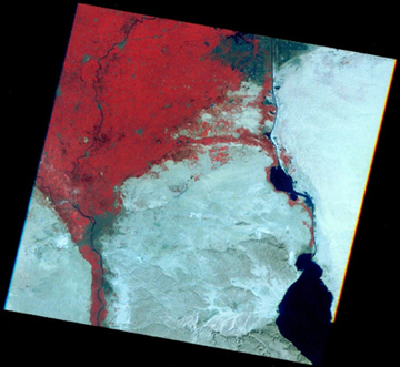 Sarah
Parcak of Cambridge University in England used this Landsat image of the eastern
Egyptian delta to locate 44 new archaeological sites in Egypt. Darker spots
on the image reveal archaeological sites and modern cities from the surrounding
landscape due to their higher moisture content.
Sarah
Parcak of Cambridge University in England used this Landsat image of the eastern
Egyptian delta to locate 44 new archaeological sites in Egypt. Darker spots
on the image reveal archaeological sites and modern cities from the surrounding
landscape due to their higher moisture content.
Parcak is taking this satellite imagery and verifying it with archaeological
data and cores from the delta in order to differentiate present-day cities from
the ancient sites, and to reconstruct settlements from Egypt's Old Kingdom —
best known for the Great Pyramids. This is the first time this methodology has
been used to locate archaeological sites.
Presenting at the American Geophysical Union meeting last December, Parcak says
she particularly wants to see how an extreme and sustained period of drought
and cooling 4,200 years before present affected the delta landscape and the
people of the Old Kingdom. Archaeologists have found many sites tied to the
Old Kingdom from before the abrupt climate change, but very few after. Thus
Parcak's research could open up the field for further research on climate change-civilization
interaction.
Megan Sever
Back to top
ICEMAN'S ORIGINS
A long the Italian-Austrian border in 1991, two German hikers made a startling
discovery: a 5,200-year-old mummy preserved in an alpine glacier. Later named
the Iceman, this Neolithic man has led to a plethora of research and debate over
the past 13 years, speculating about his lifestyle, habitat and cause of death.
The Iceman, however, left clues about his life and habitat in the chemical composition
of his remains. Through food and drink, the isotopic signatures from local rocks,
soils and water transfer to the biological minerals deposited in the human body.
Tooth enamel preserves childhood activity, and bones reveal the last 10 to 20
years before death. By comparing the Iceman's isotopic signatures to those in
the surrounding environment, geoscientists now say that they have nailed down
his likely birthplace and lifelong travel patterns.
The Iceman, also known as Ötzi (he was found in the Ötzal Alps), probably
lived his entire life — 46 years — within a 37-mile range south of the glacier
in which he was found, says Wolfgang Müller, a geologist at the Australian
National University. His birthplace was likely within a few valleys to the southeast
of where he was found — present-day northernmost Italy. He migrated during his
later adult life and seemed to spend much of his adult life a bit farther west,
Müller and colleagues suggest in an article in the Oct. 31 Science.
While Ötzi may have migrated seasonally, the evidence that he spent his entire
life in one small region demonstrates that central Europe's Alpine valleys were
permanently inhabited during the terminal Neolithic, Müller and colleagues
write.
"Knowing the Iceman's home territory will help in reconstructing the cultural
landscape in which the Iceman lived," says Thomas Loy, an archaeologist at
the University of Queensland in Australia, who has been using DNA analysis to
understand the Iceman's death (most recently speculated to have been caused by
a violent battle). Until Müller's analysis, Loy says, the Iceman was a singularity;
he was an isolated Copper Age person with no corresponding identifiable culture.
The researchers compared isotopic composition in Ötzi's teeth and bones with
soils throughout the region. Within his habitat, at least four different types
of rock are distinguishable by strontium and lead isotopes: limestone, rhyolite,
basalt and a group of mixed phyllites and gneisses. Also in his teeth and bones,
the geochemists noted distinct levels of certain oxygen isotopes that they could
then compare to known oxygen isotopes in the area, thus constraining Ötzi
to the specific watersheds in which he lived at varying stages of his life.
Although much of Müller and colleagues' findings correspond to previous research
in the region, some papers have suggested that Iceman spent a good deal of time
farther north than Müller's team suggests. But, Müller says, all the
isotopic evidence they found points to the south. In addition, the isotopic evidence
corresponds to the botanical and archaeological evidence.
In the new study, the scientists use a "combination of several techniques
pooled together to maximize information, and also new methods never utilized in
such circumstances," Müller says. One such method involves examining
argon isotopes in tiny mica flakes found in the Iceman's intestines, which constrains
his last meal to a region that holds the same mica. Loy says using combined isotopic
evidence to constrain habitat and travel ranges is "a very powerful method,"
and will be a very useful tool to investigate prehistoric people and societies.
Megan Sever
Back to top
