
Three huge waves crashed over tens of kilometers of Papua New Guinea's shoreline
on July 17, 1998. More than 2,000 people died, swept away by the 7- to 10-meter
waves. Two villages disappeared.
Initially, scientists thought the tsunami had been created by an offshore earthquake,
a magnitude-7.0 event, but the lagtime between the shaking and the waves made
geologists take another look. They found the waves were too large to fit the
earthquake that seemed to have produced them. Instead, they hypothesized, a
slumping landmass could have generated the higher and more focused waves, which
hit a discrete section of the Papua New Guinea shore. Underwater surveys showed
a large slumping bowl tens of kilometers offshore — a landslide triggered
by the earthquake, perfectly positioned to send waves caroming inland.
The ensuing controversy over whether an earthquake or an underwater landslide
generated the Papua New Guinea tsunami rekindled interest in such events; it
also drew geologists into a field that had been dominated by modelers and seismologists.
"Tsunami science used to be considered part of seismology," says Philip
Watts, an independent consultant who chaired one of several sessions on tsunamis
at the American Geophysical Union (AGU) annual meeting last December, and who
was one of the first to champion the submarine landslide's culpability. After
Papua New Guinea, that's no longer true, he says.
 Typically,
seismologists and wave modelers attributed tsunamis to the push of a thrust
fault underwater: Once an earthquake heaved a landmass up, the water would follow.
The size and acceleration of a wave would depend on the mass displaced and its
speed (slow earthquakes can still create large waves). Now, models are incorporating
what landslides over the past century, from Alaska to Nicaragua, have shown:
that a sliding landmass underwater, though it may not send a wave across the
Pacific as large earthquakes do, might create local tsunamis.
Typically,
seismologists and wave modelers attributed tsunamis to the push of a thrust
fault underwater: Once an earthquake heaved a landmass up, the water would follow.
The size and acceleration of a wave would depend on the mass displaced and its
speed (slow earthquakes can still create large waves). Now, models are incorporating
what landslides over the past century, from Alaska to Nicaragua, have shown:
that a sliding landmass underwater, though it may not send a wave across the
Pacific as large earthquakes do, might create local tsunamis.
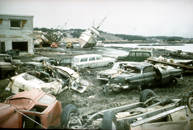
The commercial heart of Kodiak, Alaska, was devastated following the arrival
of several large seismically generated waves, an hour after the start of the
1964 earthquake. Before the offshore waves hit — at almost 20 feet above
tide level — about 160 fishing boats occupied the harbor pictured here.
However, landslide-generated waves and associated nearshore landslides caused
most of the casualties and damage. Courtesy of George Plafker.
Modeling actual tsunami waves has taken a huge step forward recently, says Jose
Borrero, a coastal engineer who works with Costas Synolakis at the University
of Southern California. Nevertheless, he says, "exactly the mechanics of
how water waves are generated, whether it be tsunamis generated from landslides
or earthquakes … are still under debate." Current models using a variety
of methods have been effective at "hindcasting" tsunamis, taking into
account fieldwork and other records. Borrero and others would like to see a
network of submarine "tsunometers," much like the seismic network
that monitors earthquake regions in California and elsewhere.
So far, the one tsunami warning system under development, the DART system built
by the National Oceanic and Atmospheric Administration (NOAA), relies on past
events for modeling current ones. Hydrophones, tide gauges and seismic reports
provide the meat for models that can forecast tsunami waves within half an hour
of their propagation. "In a nutshell, it's get the measurements as quickly
as you can and run the model … to match the measurements," says Frank
Gonzales, with the tsunami research program at NOAA's Pacific Marine Environmental
Laboratory in Seattle. Still, Gonzalez says, the system can listen only for
large events that propagate ocean-wide waves.
Nevertheless, the nascent program, deployed along the Pacific Coast of the United
States, in order to monitor and protect Hawaii, has already had some success.
As scientists reported at the AGU meeting, the system modeled the wave action
from an Alaskan earthquake last November in real time within one centimeter
of what tide gauges registered. An Alaskan earthquake — in the magnitude-7
or -8 range — can generate a tsunami that will take coastline, for example,
and can be forecast within 20 minutes or so. But if it's headed for a community
two or three minutes away, Gonzales says, "no amount of technology in the
world is going to save your life." Nevertheless, "a minute can make
a difference," he says. "The farther you run away from the water,
the weaker the tsunami will be when it catches you, regardless of the country,
regardless of the situation." Gonzales and other researchers emphasize
that education for coastal populations is the key to survival, and eventually,
he says, "an early warning can save lives."
Paleotsunami research feeds into detection and warning systems, showing what
kinds of events a region may have in its future. Characterizing older events
is much like determining historical seismicity or flood frequency for a region.
Each of the five western U.S. coastal states has a team creating tsunami hazard
maps for their coastal communities, as part of NOAA's National Tsunami Hazard
Mitigation Program, determining what regions are most at risk and for what magnitude
events.
"The geologic record is powerful," says Bruce Jaffe, a geologist with
the U.S. Geological Survey in Santa Cruz, Calif., providing records of events
where people were not present. For example, in the coastal region off the Cascadia
subduction zone, estuaries contain mud or sunken peat layers that subsided during
an earthquake and were then covered with sand brought in by a tsunami. (Radiocarbon
dating and tree-ring chronology from those estuaries also confirmed tsunami
reports in Japan, from the occurrence of a huge Cascadia earthquake in 1700,
modeled last November in Journal of Geophysical Research.)
Recent tsunami deposits on land are just as important, Jaffe says, particularly
for recognizing the older geologic evidence. He traveled to Papua New Guinea
several months after the 1998 tsunami to examine the new deposits there, as
well as to Peru after a tsunami followed a magnitude-8.4 earthquake on June
23, 2001. In general, Jaffe says, tsunami waves deposit a layer of very fine,
well-sorted sand brought in from offshore. Currently he is refining deposition
models, attempting to determine tsunami flow velocities from sediment transport
characteristics.
Researchers in the field may squabble over the details of the modeling, but
most now seem convinced that the problem is complex: a dangerous cocktail of
landslide dynamics, seismology, geology and other factors. That awareness took
a while to become mainstream, says George Plafker, a geologist emeritus at USGS
in Menlo Park, Calif. Plafker started working on tsunamis in 1964 after an immense
earthquake struck Alaska, bringing both seismic- and landslide-induced tsunamis
ashore. "There was never any question about what was going on," he
says of the one-two punch. The event included immediate waves generated by local
submarine landslides, as high as 42 meters in nearby fjords, followed by a large
seismic tsunami that followed within an hour of the earthquake, over 10 meters
high.
Since the Papua New Guinea event, models "are finally becoming realistic,"
Plafker says. "All these factors have to be taken into account before you
talk about any particular tsunami."
The shift has brought new urgency to mapping the seafloor for regions with potential
for underwater landslides, which share some characteristics of onland slope
failures. After detailed mapping of such slumps offshore Santa Barbara, Gary
Greene of the Monterey Bay Aquarium Research Institute and coworkers developed
a set of criteria for recognizing potential tsunami-producing submarine landslides,
including seismic setting, the circulation of groundwater and water inputs from
onshore rainfall, and the presence of hydrocarbon reservoirs or other porous
flow regimes. "Based on what we know today, we can predict areas that could
generate tsunamis," Greene says, "and that's where we should go out
and look."
Naomi Lubick
Back to top
 |
Geotimes Home | AGI Home | Information Services | Geoscience Education | Public Policy | Programs | Publications | Careers |