 The Tibetan plateau,
home to the Himalaya, is the highest and largest topographic feature on Earth.
Its uplift over the past 20 million years has influenced climate by shaping
air masses and driving the Asian monsoons. Although geologists know its height
today, what is less certain is its elevation at various times in the past —
which would tell scientists how fast the plateau rose and, therefore, something
about what processes were going on far below the crust. A new method, however,
using the stomata, or breathing pores, on fossilized leaves may have promise
in constructing the past heights of the landscape.
The Tibetan plateau,
home to the Himalaya, is the highest and largest topographic feature on Earth.
Its uplift over the past 20 million years has influenced climate by shaping
air masses and driving the Asian monsoons. Although geologists know its height
today, what is less certain is its elevation at various times in the past —
which would tell scientists how fast the plateau rose and, therefore, something
about what processes were going on far below the crust. A new method, however,
using the stomata, or breathing pores, on fossilized leaves may have promise
in constructing the past heights of the landscape.
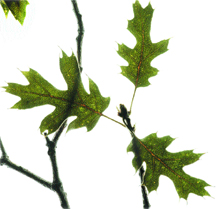
These dried leaves of a California Black
Oak, collected with permission from Mount Starr King in Yosemite National Park
at an elevation of about 7,000 feet, are about an inch long each. The leaves
become smaller at higher elevations, allowing scientists to correlate leaf characteristics
to past elevations. Image by John Weinstein; courtesy of The Field Museum.
Several methods exist to calculate such “paleoelevations,” including
looking at the size of gas bubbles in lava and the ratio of oxygen isotopes
in sediment. But “there isn’t very much that’s sensitive to altitude,”
says Peter Molnar, a geophysicist at the University of Colorado, Boulder, who
studies the formation of mountain ranges. Additionally, these methods must all
overcome the fact that very few physical processes react in a consistent way
everywhere on the planet, he says. For example, proxies for elevation that depend
on temperature, climate and latitude vary at different rates in different locales.
The new method, however, takes advantage of one factor that does change with
elevation in a physically predictable way worldwide: the partial pressure of
carbon dioxide in the atmosphere. “If you go up one kilometer in the atmosphere
at the equator or one kilometer at the pole, you’ll see the same variation”
in carbon dioxide, Molnar says, “whereas if you go up one kilometer at
the equator, the temperature change is very different from that at the pole.”
At higher altitudes, plants tend to develop more stomata in order to better
absorb the dwindling amounts of carbon dioxide for photosynthesis — a relationship
that has been understood since the 1980s. Jennifer McElwain of Chicago’s
Field Museum developed a technique that counts the number of stomata on a fossil
leaf to determine the amount of carbon dioxide that was present in the atmosphere
during its growth and, therefore, the altitude at which the plant grew, as she
reported in the December Geology.
The study used samples of California Black Oak (Quercus kelloggii) because
it grows at a wide range of elevations. Leaves collected in the 1930s for the
museum’s herbarium were used to develop and test a formula relating stomatal
density to changes in elevation. McElwain then applied the formula to a related
species, Quercus pseudolyrata, to show that the method could be applied
to species other than the one on which it was calibrated.
However, as McElwain notes, some recent studies have shown that stomatal response
varies widely from species to species. Therefore, applying a formula calibrated
on modern plants to an extinct species is a leap some are not keen on making.
“Where I see problems is the application to fossil sites,” says Robert
Spicer, a paleobotanist at the Open University in Milton Keynes, in the United
Kingdom, who also works on using fossil leaves to determine paleoelevation.
Still, he says, “this is an interesting new approach that is worthy of
further development.”
Molnar agrees, saying, “I think what she’s done is very clever.”
He worries, however, that by using leaves of plants that are extinct, there’s
no way to know for certain how the plants would react. “I see that as the
Achilles’ heel, if there is one,” Molnar says.
Additionally, unlike the method Spicer works with, which relies only on the
size and shape of fossil leaves, Spicer says that the use of stomata will require
fossil material “to be very well preserved — at the level of preserving
epidermal cell detail.” Such fossils, he says, are not easy to find. “I
know of no Tibetan material that meets this criterion.”
Other methods of determining paleoelevation can have as much as 1,000 meters
of error. McElwain reports the new method has an average uncertainty of 300
meters. Although Molnar and Spicer question such unusually low uncertainties,
they both suggest comparing the new method to old ones. Such comparisons tend
to yield good results, they say.
“All these methods have their problems,” Molnar says. Comparing them,
however, may yield “some kind of confidence that we’re getting there.”
Sara Pratt
Geotimes contributing writer
Back to top
 |
Geotimes Home | AGI Home | Information Services | Geoscience Education | Public Policy | Programs | Publications | Careers |