 Glaciers and
rivers erode the landscapes over which they traverse, shaping and molding deep
valleys and jagged mountains and cliffs. But figuring out how quickly these
processes work has long proven elusive. A new technique for calculating incision
rates, however, is shedding light on the timing of these glacial processes.
Glaciers and
rivers erode the landscapes over which they traverse, shaping and molding deep
valleys and jagged mountains and cliffs. But figuring out how quickly these
processes work has long proven elusive. A new technique for calculating incision
rates, however, is shedding light on the timing of these glacial processes.
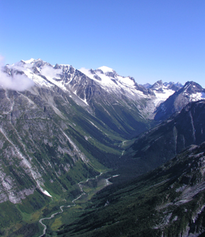
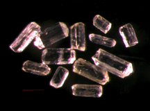
Glaciers have extensively shaped the mountains
and valleys in the southern Coast Mountains of British Columbia over the last
2 million years. A new technique for measuring the glacial erosion rate, by
dating apatite grains (below), is showing that erosion occurred faster than
originally thought. Images courtesy of Todd Ehlers.
As rivers and glaciers cut through rocks, they reveal deeper and warmer rocks;
generally, the deeper the rocks, the warmer they are. To make a connection between
a rock’s temperature and when it was glacially exposed, David Shuster of
the Berkeley Geochronology Center in California and colleagues developed a new
dating technique using helium, a byproduct of uranium decay. Helium leaks faster
from warm rocks than from cool ones. By looking at the distribution of helium
in apatite mineral grains along a topographic gradient and how long it took
for the helium isotopes to leak out of rocks, researchers were able to determine
the rates at which rocks at various elevations cooled and thus the timing of
the glacial erosion, Shuster says.
 Measuring
helium concentrations within minerals near Mount Waddington in British Columbia’s
Coast Mountains, Shuster and colleagues found that around 1.8 million years
ago, glaciers began eroding the valleys at a much faster clip than they had
over the previous millions of years, which they reported in the Dec. 9 Science.
The “dramatic increase” in the local erosion rate (incision rate),
which is at least six times faster than the longer-term erosion rate in the
valley, shows that glaciers can dramatically alter a landscape’s topography
quite quickly, which is “an important result,” says Peter Reiners
of Yale University in New Haven, Conn.
Measuring
helium concentrations within minerals near Mount Waddington in British Columbia’s
Coast Mountains, Shuster and colleagues found that around 1.8 million years
ago, glaciers began eroding the valleys at a much faster clip than they had
over the previous millions of years, which they reported in the Dec. 9 Science.
The “dramatic increase” in the local erosion rate (incision rate),
which is at least six times faster than the longer-term erosion rate in the
valley, shows that glaciers can dramatically alter a landscape’s topography
quite quickly, which is “an important result,” says Peter Reiners
of Yale University in New Haven, Conn.
Even more significant is “the power of this new technique,” Reiners
says, to “constrain the detailed time-temperature history of rocks,”
to distinguish young valleys from old ones and figure out how fast they were
carved.
“Measuring erosion rates is really hard to do,” agrees Peter Molnar
of the University of Colorado in Boulder. Shuster and colleagues “found
an innovative way to look at the history of cooling using helium,” to get
much better erosion rates than ever before. This is a technique, Molnar says,
that could be applied in many different locations to understand the timing of
topographic changes.
Megan Sever
 |
Geotimes Home | AGI Home | Information Services | Geoscience Education | Public Policy | Programs | Publications | Careers |