
 Severe
shaking awoke residents in Mozambique at 12:19 a.m. local time on Thursday,
as a magnitude-7.4 earthquake struck the seismically active region of East Africa,
according to the U.S. Geological Survey (USGS).
Severe
shaking awoke residents in Mozambique at 12:19 a.m. local time on Thursday,
as a magnitude-7.4 earthquake struck the seismically active region of East Africa,
according to the U.S. Geological Survey (USGS).
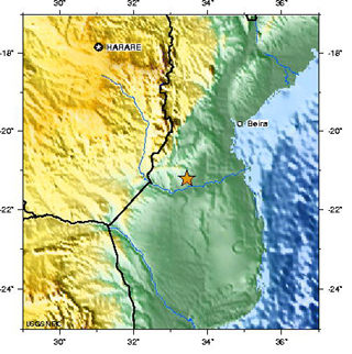
The East African Rift Zone experienced
a damaging magnitude-7.4 earthquake Thursday in Mozambique, centered about 215
kilometers southwest of Beira. Image courtesy of USGS.
The event was centered about 215 kilometers southwest of the city of Beira.
Stemming from a shallow depth of 11 kilometers, however, the earthquake could
be felt by people throughout Mozambique as well as in parts of the neighboring
countries of Swaziland, Zambia, Zimbabwe and South Africa, according to USGS.
At least five aftershocks immediately followed the main event, according the
Associated Press, and seismologists expect more small tremors
over the next week.
Shaking was strong enough to kill four people and injure at least 29 more, according
to a Feb. 24 Agence France-Presse story. Also, USGS initial
reports noted that buildings in Beira and Chimoyo sustained damage, and power
outages darkened Mozambique's capital city Maputo, 535 kilometers south of the
earthquake's epicenter.
Thursday's earthquake was not an entirely uncommon event within the East African
Rift Zone, which runs north-south about 3,000 kilometers, from Ethiopia to Zambezi.
The event Thursday stemmed from the southern end of the zone, which is being
stretched by forces that could one day lead to East Africa splitting from the
main continent (see Geotimes, Dec. 5, 2005). On
Dec. 5, the zone produced a destructive shallow earthquake centered north of
Mozambique in Tanzania — a magnitude-6.8 event that killed at least three
people.
Andrzej Kijko, the head of the seismology department at the Council for Geoscience in Pretoria, South Africa, says that seismologists expect events in the magnitude-7 range to occur about every 50 years in this area. In fact, an earthquake similar in size and location to Thursday's event occurred in 1940.
The extreme distances — up to 1,000 kilometers from the earthquake's center — to which people reported feeling the shaking are a function of Africa's unique rocks, Kijko says. The mostly homogenous rock above the junction of the South Africa plate and Somali plate offers few obstacles for traveling seismic waves.
Kijko and colleagues are studying structures that are crucial to understanding
East Africa's earthquakes. They know events are more likely at the borders between
plates, but he says that it's "more difficult to predict size and nearly
impossible to predict timing."
Kathryn Hansen
Links:
"Earthquake shakes East Africa,"
Geotimes Web extra, Dec. 5, 2005
"Developing a Scientific Workforce in
Africa," Geotimes, October 2005
USGS
report on Mozambique earthquake
Council
for Geoscience (South Africa)
Associated
Press report on Yahoo! News
Agence
France-Presse story on Yahoo! News
 |
Geotimes Home | AGI Home | Information Services | Geoscience Education | Public Policy | Programs | Publications | Careers |