
|
|
|
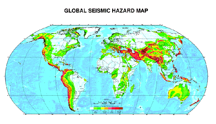
A seismic map for the world
For more information on this USGS Global Seismic Hazard map please visit
<http://seisma.ethz.ch/gshap/>
or send questions to <gshapmap@usgs.gov>.
The U.S. Geological Survey this month will
release the first quantitative map of global seismic hazards. With this
map, hazard values in any one country or region may be compared and contrasted
directly with hazard values in other regionsfor the first time ever,
says Kaye Shedlock, a USGS scientist and coordinator of the maps Western
Hemisphere portion. This will help give all countries a sense of their
relative hazard compared to the well known, hot hazard areas of the world.
For example, the map shows that the North Anatolian fault in Turkey
is actually at risk of experiencing more earthquakes than Californias
San Andreas fault, long known as an earthquake hot spot.
The map is a product of the Global Seismic Hazard Assessment Program, launched in 1992 and ended last year, which was part of the United Nations International Decade for Natural Disaster Reduction. Hundreds of scientists from most of the worlds countries cooperated to produce the map.
Previous efforts to assess global seismic hazard were qualitative, Shedlock
says. The Global Seismic Hazard Map defines a common, quantitative hazardspecifically,
probable ground motion during an earthquakefor every country. The map
defines the peak ground acceleration that has a 10 percent chance of being
exceeded in the next 50 years.
Peak ground acceleration can be applied to building codes, and the
map was created in part as a tool for planning land use and designing buildings
around probable earthquake hazards. It goes into the equation of how resources
can be better distributed, Shedlock says.
The International Lithosphere Program started the Global Seismic Hazard Assessment Program with support from the International Council of Scientific Unions as a demonstration project of the International Decade for Natural Disaster Reduction. Support for the map also came from NATO, UNESCO, the International Association of Seismology and Physics of the Earths Interior, the European Council, the European Union, the International Geological Correlation Program, INTAS (an association of the European Community for promoting science), the U.S. Geological Survey, the State Seismological Bureau in China, Instituto Nazionale di Geofisica in Italy, GeoForschungsZentrum Potsdam in Germany, and the Swiss Seismological Service in Switzerland.
Kristina Bartlett
Geotimes