
|
|
|
Finding a landing site on Mars
Ever since little green men were ruled out in the search for martian life, finding a convincing biomarker became difficult. The criteria for determining where to look for extraterrestrial organisms on the planet have changed as the size of the evidence has shrunk: from canals and cities, to nanobacteria and organic compounds. The search for life on Mars is now the goal of NASAs Mars Surveyor program. With the recent failure of the Polar Lander, deciding where to land will be critical to the missions continuation.
At the October meeting of the Geological Society of America, researchers from institutions across the nation discussed new findings in the fields of remote sensing and exobiology, the study of life as it may exist on other planets. Researchers presented several new methods for detecting and recognizing biomarkers that might be found in martian rocks and soil.
However, before evidence of life can be studied it needs to be found. And with only three landings remaining in the Surveyor program (the 2001, 2003 and 2005 missions), choosing the right landing sites is vital. This choice depends on the newest developments in remote sensing and on-site martian exploration.
Searching from Above
| From the earliest stages of site selection and throughout the Surveyor
program, remote sensing instruments onboard spacecraft have mapped the
planet from orbit for geomorphology and mineralogy. The landers and rovers
are sent to the most interesting sites to analyze materials up close. In
the final 2005 stage of the program, the landers will package specimens
and send them to an orbiting craft that will carry them to Earth.
Remote sensing provides both visual and spectral data about the martian surface and allows researchers to determine where biomarkers are most likely to occur. Life is the unifying concept behind Mars Surveyor, says Jeffrey Moersch, a remote sensing expert at NASAs Ames Research Center in Moffett Field, Calif. And because almost all life requires water, searching for existing or once-present water is one of the primary goals for remote sensing. Researchers can infer the presence of water from the presence of compounds that generally require water to formcarbonates, sulfates, clays or any other minerals associated with water chemistry. However, the carbonates are the most elusive, the Holy Grail for remote sensors, says Moersch. Any area that might be a paleo lake is a primary target, he says. These would be the places you would look for carbonates, sulfates or halidesminerals that form in the presence of liquid water, Moersch says. But carbonates have yet to be found.
|
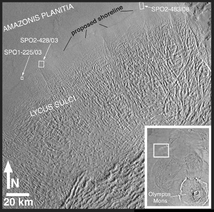
"Lycus Sulci" is the name
of a region of hills and ridges located north and
|
The jump from orbit to land moves the study from a geological one to a study of the planets chemistry and paleontology, says Harry McSween of the University of Tennessee, Knoxville, and member of the Mars Surveyor team. Fossils and unusual geochemical signatures may ultimately provide signs of life. Theres a disconnect between what youre able to measure from orbit and what will ultimately be some kind of acceptable biomarker, McSween says. Carbonates are the first step in the evaporation sequence; but McSween is looking for phosphates, where, on Earth, the most exquisitely preserved microfossils are usually found.
The next three Surveyor lander missions will have new equipment for observing fine-scale chemistry and textures. Cameras on future rovers will be able to differentiate details on the scale of microbial mat layering, with a resolution of 0.28 milliradians per pixel.
So where do we go?
The 2001 steering group has been working since 1998 to find the most appropriate stomping grounds for the next rover, Marie Curie, the spare of the Pathfinders Sojourner. Following an October workshop held in Houston, the site known as Isidis Rim was chosen as the leading candidate. The choice was not simple, for scientific goals need to be balanced with the safety of the landing site and the availability of solar energy to power the devices.
The Isidis Rim site for the 2001 landing fits these requirements. It also lies within an impact crater, and therefore may contain fragments of deeper crustal or mantle rocks. The site also contains evidence of past water in the form of networks of small channels or valleys. Finding evidence for fossil life is not the only goal of the 2001 mission. But if life once existed on Mars, Isidis Rim is one of the first places to look.
Josh Chamot
Geotimes contributing writer