Geotimes

Feature
Investigating
the Paleoclimate of an Arctic Gateway
Julie Brigham-Grette,
Lloyd Keigwin and Neal Driscoll
Sidebars:
Studying a submerged land bridge
The original Healy
The drilling routine
 In June of 2002, the
icebreaker U.S. Coast Guard Cutter Healy set off from Nome, Alaska, for its first
geoscience research mission in Alaskan waters. Carrying about 20 scientists from
five institutions and a Coast Guard crew of 75, the Healy, under the command of
Capt. Dave Visneski, was decked out with the best equipment for coring marine
sediments and collecting sonar images of the seafloor and continental shelves.
In June of 2002, the
icebreaker U.S. Coast Guard Cutter Healy set off from Nome, Alaska, for its first
geoscience research mission in Alaskan waters. Carrying about 20 scientists from
five institutions and a Coast Guard crew of 75, the Healy, under the command of
Capt. Dave Visneski, was decked out with the best equipment for coring marine
sediments and collecting sonar images of the seafloor and continental shelves.
The clues for this scientific investigation were beneath the treacherous waters
of the Bering Sea and Chukchi Sea. Working within a project funded by the National
Science Foundation (NSF), we were on a mission to collect sediments from these
seafloors and the intervening shallow continental shelf to determine the recent
sea history for the Bering Strait region. It was in this region that sea-level
drop exposed a land bridge 20,000 years ago — the proverbial bridge across
which early people and many other types of mammals presumably entered the New
World.
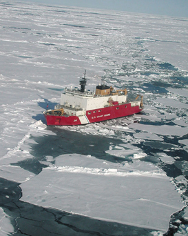
Breaking the ice:
The U.S. Coast Guard Cutter Healy breaks ice on the Arctic Ocean during a nine-week
cruise in August 2001. With funding from the National Science Foundation, the
cruise was the first scientific voyage for the Healy, and the scientists onboard
set out to investigate a slow-spreading mid-ocean ridge, the Gakkel Ridge. They
found that the ridge may be more volcanically active than previously thought.
Last summer, Healy set out again, this time to help a research team sample the
seafloor beneath the Bering Sea and the Chukchi Sea to find clues about past climate
and sea-level changes in the western Arctic. Photo by Henry Dick, Woods Hole Oceanographic
Institution.
As we continue our research, we are interested in how this sea-level history influenced
the past oceanography of the water masses on either side of the land bridge. Despite
the importance of this marine gateway between the Atlantic and Pacific oceans,
the recent geologic history of these sea floors remains poorly explored. Our goal
was to collect sediment cores, seismic data and oceanographic measurements in
order to unravel broad questions surrounding the paleoclimatic history of this
western Arctic gateway.
By the end of our fieldwork last summer, we collected more than 100 different
cores from the seafloor sediments.
The Bering Strait, today connecting the Bering and Chukchi seas, sits in the middle
of a vast subcontinent known as Beringia. This entire region of land and sea stretching
from the Kolyma River of northeastern Siberia to the Mackenzie River in the Yukon,
is critically important to Earth’s climate system. Only 20,000 years ago
during the last glaciation, when sea level was about 130 meters lower than it
is today, the land bridge separated the deeper Bering Sea and North Pacific Ocean
from the Arctic Ocean. As sea level goes up and down due to changes in the size
of the world’s ice sheets and glaciers, the Bering Land Bridge serves at
times as a continent and at times as an ocean gateway, producing a geographic
bottleneck to the migration of terrestrial and marine biota.
The floors of the Bering and Chukchi seas are some of the most extensive continental
shelves on Earth. Their low gradient makes them very sensitive to relative sea-level
changes and they could play a key role in global climate.
The common research vessel for collecting cores of marine sediments is a Class-1
UNOLS ship (of the University-National Oceanographic Laboratory System) outfitted
for long (at least 20 meters) piston coring. But none of these ships will go to
the Chukchi Sea because of the threat of sea ice. Thus, we proposed using the
USCGC Healy, which is designed to cut through sea ice, for its first geological
science mission in Alaskan waters. We spent our first three-week research cruise
in the Bering Sea in late June and early July and our second in the Chukchi Sea
in late August to the middle of September.
Where ocean and climate interact
The history contained in the cores we collected can tell us a great deal about
changes in sea level and climate, and add to our understanding of global change
in Earth’s past. One of the major scientific goals in studies of past climate
change is to quantify the range and dynamics of natural variability in Earth’s
systems on a variety of time scales.
A key mechanism in Earth’s climate system is the coupling between ocean
and climate. Studies that help us to understand this coupling — such as
correlations between marine sedimentary records and terrestrial records —
are of particularly high priority because they are tools for learning more about
the climate system’s dynamics and feedbacks. The arctic regions are exceptionally
sensitive to climate change and are thought to amplify changes in the global
system.
Glacial-interglacial cycles have imposed on the Bering Strait region some of
the most radical changes in paleogeography documented in the Northern Hemisphere.
These changes, in turn, have helped to drive equally radical changes in arctic
climate. With sea level rise, for example, the rapid migration of shorelines
and encroachment of the sea would have locally cooled nearshore sites by changing
summertime gradients in temperature and moisture. The greatest east-west heterogeneity
across Beringia occurred during warm (flooded) or warming (partially flooded)
periods of late Pleistocene summers, when the cool maritime influence bifurcated
the relatively warm continental interior, as suggested by Patricia Anderson
and Anatoly Lozhkin in the January 2001 Quaternary Science Reviews. When
the Bering shelf is at least partially flooded, the sea seems to have considerable
“down-wind” effects.
Oceanographic changes would also have been radically influenced by changes in
sea level across the Bering Strait that regulated the northward flow of Pacific
waters into the Arctic Ocean and North Atlantic. Today, the less saline Pacific
waters supply nearly one-third of the total freshwater input to the Arctic Ocean
(half that of riverine inputs), maintaining the modern halocline while influencing
the strength of thermohaline circulation in the North Atlantic. Any change in
this system would have impacted global ocean circulation in ways that remain
unclear.
Despite their importance, the paleoceanography and sea-level history of the
Bering Strait region, viewed by some as the Arctic Ocean’s leaky back door,
remain poorly studied. In contrast, decades of detailed study and modeling of
the paleoceanography of the North Atlantic, Norweigian Sea and Greenland Sea
continue to yield important information about the cyclicity and dynamics of
thermohaline circulation in these water bodies, and of this circulation’s
impact on global climate. Studies of terrestrial and near-shore paleoclimate
from across the Yukon, Alaska and northeast Russia are also extensive, as demonstrated
by a compilation of this research in the January 2001 Quaternary Science Reviews.
Seeing this compilation of Beringian paleoenvironmental history, we recognized
the need to study high-resolution records from the Bering Sea and Chukchi Sea
for comparison. Sorely missing from existing literature are studies of how these
seas participate in controlling Beringian climate. Understanding this relationship
could give us a fuller appreciation for the role of the Beringian gateway in
the global climate system.
Especially important is an understanding of how the flow of water through the
Bering Strait influences thermohaline circulation in the North Atlantic by changing
the flux of fresher water into the Arctic Ocean. While we know that sea-surface
conditions such as ice extent, temperature and salinity likely influenced global
climate through albedo effects, heat exchange and humidity, we previously had
very little high-resolution proxy data for these properties from the Bering
Sea and Chukchi Sea. Changes in the surface water conditions and the amount
of water flowing toward the North Atlantic were also likely influenced by changes
in sea level.
Stories of changing sea level
One of the major science goals of our project is to gain new insights into
the history of sea-level change through the Bering Strait. We hypothesized it
is likely to have differed from global sea-level change because of both global
changes in glacial sea level and because of tectonic forces in the Bering Strait
region.
For example, estimates have varied on how long and how late after the last glacial
cycle the land bridge was exposed. In a 1997 issue of Palaeogeography, Palaeoclimatology,
Palaeoecology, Scott Elias and his colleagues updated estimates of post-glacial
sea level rise, saying that the Chukchi shelf was inundated and water began
to flow through the Bering Strait when sea level was at negative 50 meters water
depth by 11,000 years before the present. This new age estimate is significant
because it suggests the land bridge was exposed 3,800 years longer than the
time period postulated in 1984 by Dean McManus and Joe Creager in Quaternary
Research.
However, the new estimate was based on only a few radiocarbon dates of terrestrial
material from the Chukchi Sea. Nevertheless, submergence of the land bridge
shortly after 11,000 years before the present is indirectly supported by evidence
for the arrival of endemic Pacific mollusks and the reestablishment of a seasonal
whale migration to the Beaufort Sea between about 10,000 and 10,500 years before
the present, as first published in 1996 by Canadian geologist Art Dyke in the
journal Arctic. These new dates, though significant, only provide data marking
the position of sea level for isolated locations on the shelf at the same depth.
What was needed to help quantify how long the land bridge was exposed was a
transect of cores from deep-water sites up onto the shallow continental shelf
from a range of depths to more accurately define the migration of the shoreline
through time. The cores we collected last summer cover such an area. Moreover,
we needed to assess any new sea level history against the influence of subtle
flexing of the lithosphere due to the subduction processes and tectonics across
this region of Alaska and northeast Russia.
We chose the Chukchi for reconstructing relative sea level because it offered
a greater likelihood for better coring locations on the shelf. Pleistocene marine
and terrestrial deposits on the Bering shelf are more likely to be reworked
and eroded than on the Chukchi shelf, because the former is less protected by
sea ice and more exposed to powerful storms from the southwest, which have a
long fetch. Previous work, especially that led by geologist Larry Phillips of
the U.S. Geological Survey, documented the existence of numerous buried channels
and valleys dissecting the Chukchi shelf that appear to record several changes
in sea level. By sampling near the channel thalwegs (the steepest parts of the
channels), we hoped to acquire thick estuarine sequences from which we could
establish a chronostratigraphic framework for each estuarine section. Ideally
we hoped to also find fossiliferous marine sediments overlying the sandy estuarine
deposits. Such sediments would allow us to bracket the sea level rise with radiocarbon
ages on the youngest terrestrial and oldest marine deposits.
Based on the seismic data from these cruises alone, we are encouraged that we
have identified many of the complexities of the stratigraphy of the Chukchi
shelf. Nested series of eroded and back-filled channels and channel systems
across the shallow shelf indicate that a much longer record of sea level change
is available in the sediments we cored. In deep-water sites, we located thick
piles of flat-lying, undisturbed sediments that likely contain critical information
for understanding the long history of the deeper portions of the Bering and
Chukchi seas. In a few places, the coring equipment wasn’t long enough
to sample all of the sediment. However, knowing where to find such “sweet
spots” on the ocean floor is half of the scientific puzzle in this line
of work.
Given this new knowledge and our future results from the cores we have collected,
the data will allow us to ask new scientific questions of the regional paleoclimate
history and the influence of the oceans on the terrestrial environment. By improving
upon what was known from these oceans before, we will also be in a better position
to help define the role and history of the Bering Strait in the global climate
system.
|
Studying
a submerged land bridge
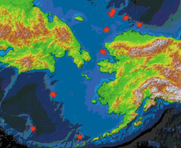 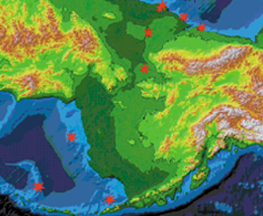 The
terrain and bathymetry map at near right shows the Bering Strait region
as it might have appeared during the Last Glacial Maximum, about 20,000
years ago. Sea level might have been 125 meters lower than today (this
comparison does not compensate for Holocene sedimentation or tectonic
forces). This drop opened a land bridge that probably allowed humans and
other mammals to migrate to the New World. The
terrain and bathymetry map at near right shows the Bering Strait region
as it might have appeared during the Last Glacial Maximum, about 20,000
years ago. Sea level might have been 125 meters lower than today (this
comparison does not compensate for Holocene sedimentation or tectonic
forces). This drop opened a land bridge that probably allowed humans and
other mammals to migrate to the New World.
The map on the far right shows the region today. Sea level is higher and
the land bridge is submerged. Stars indicate where the Healy team took
cores from the seafloor. These stars are also indicated on the upper map
for comparison.
Both maps were created by William F. Manley of the Institute of Arctic
and Alpine Research at the University of Colorado. See online
animations of the flooding of the land bridge over time.
Back to top
|
| The
original Healy
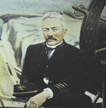 In the
late 1800s, Capt. Michael Healy of the Cutter Bear was a celebrated officer
in the Marine Revenue Cutter Service. He protected the interests of the
U.S. government along the coast of Alaska. Known as one of the greatest
arctic navigators of the time, “Hell Roaring Mike Healy” stood
for justice in the early years of the new American Arctic. In the
late 1800s, Capt. Michael Healy of the Cutter Bear was a celebrated officer
in the Marine Revenue Cutter Service. He protected the interests of the
U.S. government along the coast of Alaska. Known as one of the greatest
arctic navigators of the time, “Hell Roaring Mike Healy” stood
for justice in the early years of the new American Arctic.
He warned of the potential over-harvesting of marine mammals, and he protected
the interests of native communities and new settlers alike, as both were
vulnerable to the Alaskan frontier’s lawless times. At right is a
photo of the oil painting of Capt. Healy that is onboard the ship named
for him, the U.S. Coast Guard Cutter Healy.
True to its namesake, the USCGC Healy patrols and protects U.S. waters
while carrying civilian scientists into the Arctic ice pack as far as
the North Pole. Commissioned in 2000 as the largest icebreaker in the
U.S. fleet, it is also a scientific platform for exploring the Arctic.
JBG
Back to top
|
| The
drilling routine
 As
with any major oceanographic cruise on a ship the size of Healy, time
really does equal money. Our goal was to sample as many areas of the floors
of the Bering Sea and Chukchi Sea as possible in each of our three-week
cruises. As
with any major oceanographic cruise on a ship the size of Healy, time
really does equal money. Our goal was to sample as many areas of the floors
of the Bering Sea and Chukchi Sea as possible in each of our three-week
cruises.
We employed a two-pronged approach to rapidly locate regions of continuous
deposition with minimal unconformities caused by past continental slope
failure. We used existing GLORIA side-scan sonar data (Geologic Long-Range
Inclined Asdic) from the U.S. Geological Survey, along with accompanying
single-channel seismic data, to identify broad sediment targets. We then
used our Scripps Edgetech CHIRP system, a seismic system that creates
images of the seabed at a resolution of less than a meter to penetration
depths of more than 50 meters. By combining the CHIRP data with the shipboard
swath bathymetry, we could easily locate the exact coring targets.
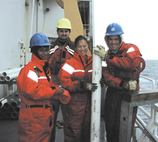
Core on deck: Deck operations included scientists
from several institutions. From left to right are Ana Carmo of the University
of Kentucky; graduate students Zach Lundeen of the University of Massachusetts,
Amherst, and Mea Cooke of the Woods Hole Oceanographic Institution; and
undergraduate student Alex Zaveruha of Western Washington University.
Photo by Julie Brigham-Grette, University of Massachusetts, Amherst.
By day, we set up 40 coring stations to take four-inch-wide cores of the
seafloor sediments. Depending on which of our coring systems we used,
the cores would range between 80 centimeters long and 21 meters long.
By night the seismic crew monitored the charts, identified coring targets,
and collaborated with the bridge to set the ship’s course on a grid
of transects that mapped the seafloor in a pattern you might otherwise
make mowing your lawn.
Coring sandy shelf sediments is nearly impossible using conventional piston
coring equipment. To optimize our chances for recovery at shallow shelf
depths, we used a submersible vibracore system — which literally
vibrates the core barrel into the seafloor — designed by Neal Gielstra,
Paul Gayes, Liz Johnstone and Jamie Phillips from Coastal Carolina University.
It worked beautifully at first, but soon the summer’s unexpected
lack of sea ice proved to be a mixed blessing.
On the one hand, the lack of sea ice meant rough waters, making it difficult
to hold the ship on station without an anchor and take cores. More than
once we exceeded the vibracore system’s design specifications, but
we accomplished our goals. On the other hand, the open water and warm
weather allowed us to use the CHIRP system freely and obtain very high-resolution
images of the seafloor and the shelf stratigraphy in areas where even
coarse resolution data had not been collected before.
By the end of our fieldwork, we had collected cores from between negative
2,800 meters to negative 50 meters water depth. We had an outstanding
set of nearly 100 different marine cores together measuring more than
500 meters. Some are the longest cores ever taken in this part of the
western Arctic.
JBG
Back to top
|
Brigham-Grette
is a professor in the Department of Geosciences at the University of Massachusetts-Amherst.
Email her at juliebg@geo.umass.edu.
Keigwin is a senior scientist and paleoceanographer at Woods Hole Oceanographic
Institution. And Driscoll is an associate professor with the Scripps Institution
of Oceanography, University of California-San Diego.
National Science Foundation (NSF) funding for this project is from the Arctic
Natural Sciences program of the Office of Polar Programs (Jane Dionne, program
manager) with contributions from the Paleoclimate Program (David Verardo, program
director) and the Arctic System Science Program (Neil Swanberg, program manager).
