Geotimes

Feature
From
Magnetism to Meteorites: Research at the Poles
Geotimes staff
As part of the International Geophysical
Year in 1957, several countries cooperated to send research expeditions
to Antarctica, jump-starting scientific research on the continent. Two years
later, 12 nations signed the Antarctic Treaty, an agreement that the continent
will be used for peaceful purposes only and as a place for scientific research.
By 2000, 45 countries had signed onto the treaty. The continent has been
an active science laboratory. According to the Council of Managers of National
Antarctic Programs, 26 different countries host 82 research stations in
Antarctica.
Security issues and natural resources have driven U.S. research interests
at the other pole — a history that starts in 1897 with the purchase
of Alaska. In 1984, to better coordinate federal research in the polar region,
Congress passed the Arctic Research and Policy Act. The National Science
Foundation became a lead agency for implementing Arctic research policy,
and soon formed the Office of Polar Programs.
Geoscientists working at the poles are unraveling Earth’s history —
from very old records of mountain belts and plate motions, to relatively
recent records of climate change stored in ice cores. The following suite
of articles provides a glimpse at three areas where current research is
making strides. Geophysicists studying Earth’s magnetic field are taking
to the poles to understand a rapid decrease in magnetic field intensity.
The snowy expanses of Antarctica and Greenland are prime hunting ground
for geoscientists studying meteorites, providing a chilly window into the
origin of the solar system and beyond. And remote sensing has revolutionized
our ability to measure the total size of ice sheets and how that size is
changing. |
Deciphering Earth's dicey dipole
Meteorites on ice
An expanding view of polar ice sheets
Deciphering
Earth's dicey dipole
 In October
2000, Discover magazine ranked the top 20 ways the world could end. At
number six was a reversal of Earth’s magnetic field. The magnetic field,
created by convection in Earth’s fluid outer core, forms a protective shield
around the planet, blocking out harmful solar radiation and particles from deep
space. Every few hundred thousand years, the field intensity drops down close
to zero and then gradually reappears with the poles at opposite ends of the globe.
The magnetic poles form the northern and southern ends of an imaginary giant bar
magnet.
In October
2000, Discover magazine ranked the top 20 ways the world could end. At
number six was a reversal of Earth’s magnetic field. The magnetic field,
created by convection in Earth’s fluid outer core, forms a protective shield
around the planet, blocking out harmful solar radiation and particles from deep
space. Every few hundred thousand years, the field intensity drops down close
to zero and then gradually reappears with the poles at opposite ends of the globe.
The magnetic poles form the northern and southern ends of an imaginary giant bar
magnet.
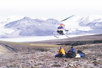
University of Rochester students Karrie
Weaver (left) and Doug Laity wait for helicopter transport on Axel Heiberg Island
in the High Canadian Arctic, on an expedition to measure the intensity of the
ancient magnetic field from lava basalts. Some researchers think the field is
on the brink of a reversal, and the ancient data provide additional evidence.
University of Rochester.
“On geological time-scales, Earth’s magnetic field, grossly dipolar,
presents stable polarity intervals, with duration on the order of a few hundreds
of thousands of years, interrupted by sharp reversals from one polarity to the
other,” says geophysicist Mioara Mandea of the Institut de Physique du Globe
in Paris. The latest reversal happened nearly one million years ago, which has
many researchers wondering whether Earth is due for a magnetic flip soon.
Some geophysicists, who have noticed a rapid decline in the strength of Earth’s
magnetic field, say the field is showing signs of an imminent reversal. Others,
however, argue that the field’s intensity could easily bounce back.
“Where we’re on solid footing is that the overall intensity of Earth’s
magnetic field is decreasing, and it’s decreasing quite rapidly. It’s
actually decreasing more rapidly than if we turn the convection in the core off
and let the field decay away,” says John Tarduno, a geophysics professor
at the University of Rochester. “That does not necessarily tell you that
you’re heading toward a reversal.”
If the field intensity continues as it has, it will reach zero intensity in 2,000
years or so, Tarduno says. But, he cautions, the field’s intensity, even
though it’s decreasing very rapidly, is higher than the long-term average.
Also, “there are many times in the records we have so far, where the record
appears to be dropping rapidly and then increases again,” says Tarduno, who
conducts research up near the North Magnetic Pole, located about 966 kilometers
from the geographic North Pole, and moving northwest about 40 kilometers per year,
according to a recent survey (Geotimes, May 2002).
The North Pole is the birthplace of geomagnetic research, which began in the 19th
century. Roald Amundsen, on his search for the Northwest Passage, set up a temporary
magnetic observatory to relocate the pole found 70 years earlier by James Clark
Ross. Now, geomagnetic researchers look at Earth’s magnetic field in a variety
of ways — from space, from computer simulations and right from the source
in the cold, remote Arctic.
Tarduno and his students have ventured up to the Arctic four times over the past
decade to reconstruct the history of Earth’s magnetic field as recorded in
lava basalts near the pole. “Most of our work is geared at understanding
the long-term history of the magnetic field as well as understanding the basic
relationships between the characteristics of the field, which have been hard to
define,” he says.
They measured the paleointensity of the magnetic field from plagioclase crystals
in arctic lavas 95 million years old that represent a superchron, a time period
without magnetic reversal for millions of years. “What we’ve found is
that during this time interval, the field appears to be unusually strong —
two to three times stronger than the long-term average of the field, over the
last 160 million years, and it seems to be remarkably stable,” Tarduno says.
Their work, published in the Oct. 29 Proceedings of the National Academy of
Sciences and funded by the National Science Foundation and Canada’s Polar
Continental Shelf Project, therefore suggests that magnetic field intensity is
related to other components of the field, including the rate of reversal.
Recent and prior work with satellite data has highlighted other possible relationships
in the magnetic field that could point toward a reversal. This past April, Gauthier
Hulot, Mandea and colleagues published in Nature the presence of patches of reversed
magnetic intensity in the Southern Hemisphere, which may have something to do
with the decrease in field intensity over the past couple hundred years, and could
be precursors to a dipole reversal.
Tarduno’s team looked for evidence of similar patches of disturbances in
the ancient magnetic field but did not find any. “We believe it is because
the field was in an unusually strong and stable — non-reversing — configuration,”
Tarduno says.
Researchers think that the convection in the outer core, which drives the magnetic
field, creates these patches. “What you need to do is maintain that pattern
in the outer core long enough so that the reversal can actually propagate through
the inner core. That’s the trick,” Tarduno says.
Indeed, Gary Glatzmaier of the University of California at Santa Cruz says that
instabilities such as the Southern Hemisphere patches are common in “geodynamo”
simulations, but do not usually survive. “Once in many attempts the fluid
flow and thermodynamics happen to be right for instability to continue to grow
while the original field polarity is being destroyed and sometimes, after several
thousands of years, this reversed polarity can take over the entire core,”
he explains. “The process of a dipole reversal is very complicated and chaotic
and I would imagine there’s no simple explanation.”
Tarduno hopes to return to the Arctic soon to learn more about Earth’s geomagnetic
past and the geodynamo that charged it. Although he does not expect a dipole reversal
in the immediate future, he does say that the patches of reversed flux in the
South Atlantic have been causing and will continue to cause more radiation to
hit satellites above those regions.
Lisa M. Pinsker
Back to top
Meteorites
on ice
Stellar explosions of red giants and supernovas send star dust careening through
the universe. For billions of years the galactic grains travel away from their
solar systems. More than a thousand times smaller than sand, the tiny diamonds
and other minerals carry an encrypted message: noble gases with the atomic signatures
of their parent star.
 Eventually
the dust travels through the Milky Way Galaxy to another solar system —
one early in its formation. The dust becomes part of a growing cloud of molecular
material forming planets, the Sun and asteroids. It is these asteroids, between
Jupiter and Mars, that have locked the secrets of other solar systems away for
4.5 billion years. But often chunks of the asteroids break off and spin in a
collision course toward the Sun, only to crash en route instead on the Moon
or any planets that might cross their paths. Of the ones that hit Earth, only
a small fraction make it through the atmosphere and even fewer are ever found.
Eventually
the dust travels through the Milky Way Galaxy to another solar system —
one early in its formation. The dust becomes part of a growing cloud of molecular
material forming planets, the Sun and asteroids. It is these asteroids, between
Jupiter and Mars, that have locked the secrets of other solar systems away for
4.5 billion years. But often chunks of the asteroids break off and spin in a
collision course toward the Sun, only to crash en route instead on the Moon
or any planets that might cross their paths. Of the ones that hit Earth, only
a small fraction make it through the atmosphere and even fewer are ever found.
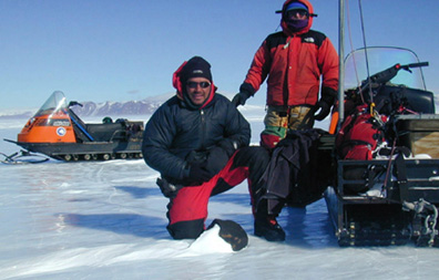
Jamie Pierce (left) and John Schutt are
part of the Antarctic Search for Meteorites program. Here, they recover the
largest ordinary chrondrite (20 kilograms) of the 2001-2002 season. They are
pictured here on the Meteorite Hills icefield, Darwin Mountains, East Antarctica.
ANSMET/Linda Martel.
Astronomers have gazed through their telescopes to learn of the birth of stars
and poets have written about dust trails from comets that blaze as meteor showers
in the night sky, while meteorites quietly have accumulated on the frozen ice
sheets of Antarctica.
Japanese glaciologists first discovered the bounty there for the taking in 1969.
After hearing about nine specimens from four different types of meteorites the
Japanese scientists reported finding, William Cassidy of the University of Pittsburgh
asked the National Science Foundation (NSF) to fund a similar expedition near
the American base at McMurdo Sound. NSF, however, rejected the idea, twice.
The third time was the charm.
Since Cassidy’s first two-person expedition in 1976, the Antarctic Search
for Meteorites (ANSMET) program Cassidy established with NSF support has brought
back 11,647 meteorites, including six martian meteorites and the first identified
lunar meteorites. With the Japanese collection counting now at 16,500, nearly
90 percent of the currently known samples collected on the planet have come
from Antarctica.
Each austral summer, the team of meteorite hunters travels to McMurdo Station
and prepares for six weeks of field camp in remote sections of the continent.
The cost of the expedition runs about $120,000 per person. “That includes
everything: six weeks on the ice, two weeks there and back traveling, insurance,
every drop of fuel for the planes, room and board at McMurdo — people forget
how much it costs to do research on Antarctica, but we’re pretty cheap
compared to a lot of other projects,” says Ralph Harvey of Case Western
Reserve University, who began leading ANSMET in 1991 as principal investigator
of the grants after Cassidy retired.
This season, for the first time, NASA is joining NSF in supporting the ANSMET
fieldwork. The additional funding has allowed a reconnaissance team of four
to scout out the Transantarctic Mountains near the South Pole with the aid of
a Twin Otter plane. A larger team of eight is using snowmobiles to conduct systematic
searches of the Transantarctic Mountains in two regions: Goodwin Nunataks and
MacAlpine Hills, both about a day’s journey from the Beardmore Glacier.
Harvey calls the organized grid-pattern search akin to a giant Easter egg hunt.
The team members are lined up on their snowmobiles about 50 feet apart and set
off in parallel lines across the Polar Plateau.
The Antarctic Ice Cap receives meteorites on its surface and then over hundreds
of thousands of years smuggles them into its deep interior while the ice creeps
slowly across the continent. An unknown number are lost at sea where the ice
travels over the continental edge and breaks into icebergs. But in areas such
as near the Transantarctic Mountains, where the wind whips the ice into a frozen
ocean of brilliant blue, ablating the upper layer through evaporation, the meteorites
are revealed once more.
Before the expedition, Scott Messenger joined others at McMurdo station over
the Thanksgiving weekend for a 5-kilometer foot race. While Messenger will have
a snowmobile to help him with the meteorite hunt, the race put the team in good
spirits. With clear weather on Dec. 7, they returned from their first day of
collecting with 21 meteorites.
Back at Washington University in St. Louis, Messenger is one of a growing number
of researchers working in a new field studying interstellar grains and their
bizarre records of noble gasses. The first indication that meteorites held interstellar
material occurred in the 1960s when researchers found unusual isotopic ratios
of the elements neon and xenon. “Something strange was spooking around
in the meteorites,” says Edward Anders, now retired from the University
of Chicago. When heated under extreme temperatures the noble gasses escaped
with wildly ranging isotopic ratios unknown to this solar system. “Meteorites
are a god-awful mix of the whole periodic table.”
Anders and his team had a hunch that the mysterious mineral might be pentlandite,
which the text books claimed could withstand acid. While William Cassidy was
struggling to persuade NSF to fund ANSMET in the early 1970s, Anders and his
team soaked meteorites in an acid bath overnight until all that was left was
a black residue. The first test showed successfully that the strange noble gases
still remained. But the black mineral residue wasn’t pentlandite. “We
had a long tradition of doing the right experiment for the wrong reason,”
Anders says. After 12 years of working on and off the project to identify this
black sludge, it took a technological fluke for his team to discover at least
one of the minerals in the meteorites that could hold such gases.
In 1987, John Wacker, a post-doc on the project, left a fresh sample of this
black residue on a hot plate overnight to dry and further tease out the mystery
ingredients. But when the thermometer malfunctioned and the hot plate became
much hotter than it was set for, “the next morning the black stuff turned
white and the noble gases were still there,” Anders recalls. Another post-doc,
Roy Lewis, checked out the X-ray diffraction pattern and saw lines of diamonds.
“Of all things, diamonds,” Anders remembers.
Working with colleagues who had access to an ion microprobe at Washington University,
the researchers identified silicon carbide and graphite as also carrying the
noble gasses from another solar system. Other researchers have since identified
four more presolar grain minerals. In 2000 Messenger presented a way to find
presolar grains caught in Earth’s atmosphere using high-altitude aircraft.
On the horizon, the meteorite hunters are looking for something else too: meteorites
from Mercury and Venus. Theory has it that the meteorites exist, indeed they
might already sit in the collections at the Johnson Space Center or at the Smithsonian
categorized as ungrouped meteorites. But nobody knows yet just what special
link will identify them, or just where on the ice sheet they may turn up.
Christina Reed
Back to top
An
expanding view of polar ice sheets
The Greenland and Antarctic ice sheets hold a vast amount of Earth’s freshwater.
If the two sheets melted completely, they would raise the sea level by almost
70 meters. Even a fractional change in the volume of the sheets would significantly
impact sea level. One of the major research efforts at high latitudes is to understand
how polar ice sheets will respond to a climate likely to warm over the next century.
 The overall
scientific picture of the polar ice caps, as summarized in the Intergovernmental
Panel on Climate Change (IPCC) assessment published in 2001, is that Greenland
and Antarctica may contribute up to a maximum of 11 centimeters to sea-level rise
over the next century. However, uncertainty underlies these projections. Ice sheets
shrink when more mass is lost from melting and glacier discharge than is gained
from precipitation; they grow when that balance shifts in favor of precipitation.
Since global climate change could increase precipitation over the poles, the IPCC
assessment concluded that the polar ice sheets may not contribute to a rise in
sea level at all. They may even offset a rise from other mechanisms — such
as thermal expansion of ocean water and melting of nonpolar glaciers — by
as much as 19 centimeters.
The overall
scientific picture of the polar ice caps, as summarized in the Intergovernmental
Panel on Climate Change (IPCC) assessment published in 2001, is that Greenland
and Antarctica may contribute up to a maximum of 11 centimeters to sea-level rise
over the next century. However, uncertainty underlies these projections. Ice sheets
shrink when more mass is lost from melting and glacier discharge than is gained
from precipitation; they grow when that balance shifts in favor of precipitation.
Since global climate change could increase precipitation over the poles, the IPCC
assessment concluded that the polar ice sheets may not contribute to a rise in
sea level at all. They may even offset a rise from other mechanisms — such
as thermal expansion of ocean water and melting of nonpolar glaciers — by
as much as 19 centimeters.
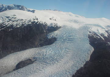
Glaciologists took this picture as they
flew over Patagonian ice fields on Dec. 7. The flight was part of a joint effort
between Centro de Estudios Cientificos of Chile and NASA to remotely measure ice
thinning rates of glaciers in Antarctica and Patagonia. CECS/NASA.
A major source of uncertainty in projecting the growth or decline of ice sheets
is that Greenland and Antarctica span immense areas; but precipitation patterns,
melting rates and glacier velocities — the parameters that control the size
of the ice sheets — vary over several kilometers. Assembling a comprehensive
picture of ice sheet dynamics requires analyzing an entire ice sheet at high resolutions,
a daunting task. However, recent advances in remote sensing have rapidly accelerated
progress toward a global view of the ice sheets — and their sensitivities
to climate changes.
“The past 10 years have revolutionized glaciology through the widespread
application of remote sensing to infer conditions over vast areas and over time,”
says Robert Thomas, a glaciologist with EG&G Services at NASA in Wallops Island,
Va., who has been studying polar ice sheets for about 40 years and co-authored
a review in the Aug. 30, 2002, Science of research in Greenland and Antarctica.
A remote-sensing technique called Interferometric Synthetic Aperture Radar (InSAR)
is revealing the speeds of glaciers within the polar ice sheets — data critical
for nailing down Antarctica’s overall mass balance. Unlike Greenland, Antarctica
is so cold throughout the year that hardly any surface ice melts. The sheet loses
mass primarily through glaciers that discharge solid ice into the ocean. With
InSAR, satellites emit pulses of microwaves and measure the properties of returning
waves to discern features on the ground. Overlapping two or more images separated
in time and covering the same section of an ice sheet allows researchers to determine
the speeds of glaciers down to an accuracy of a few meters per year.
Eric Rignot, a glaciologist with NASA’s Jet Propulsion Laboratory, used InSAR
data to show that one of the largest glaciers in Antarctica, Pine Island glacier,
has been retreating quickly over the past decade. The glacier has also discharged
18 percent more ice into the ocean per year than it did a decade ago. “Glaciologists
had hypothesized that this glacier was one of the most susceptible to possible
global climate changes, but there was no good glaciology data to confirm or deny
it. Thanks to the satellite data, we’ve been able to look at this glacier
without setting a foot on it,” Rignot says. The larger implication, Rignot
explains, is that even in Antarctica, glaciers respond to changes in climate on
time scales of decades, not in the hundreds or thousands of years assumed by most
predictive models of the evolution of the ice sheet in a changing climate.
Other InSAR data indicate that certain sections of the Antarctic ice sheet are
growing or not changing in size. Ken Jezek, a glaciologist from Ohio State University,
has used InSAR to determine the velocities of ice streams draining into the Filchner
Ice Shelf, one of the larger shelves in Antarctica. He and colleagues found that
the mass added annually by snow roughly equals the amount discharged to the sea.
Thomas spends many of his research hours cruising over polar ice sheets in a low-flying
aircraft. A laser mounted to the plane pulses thousands of times per second, precisely
measuring the distance from the plane down to the ice sheet. Since 1991, he and
colleagues have been using this technique to develop maps of much of Greenland’s
topography. A low frequency radar, also mounted to the plane, complements the
topographic data by measuring the thickness of ice down to depths exceeding four
kilometers.
By repeating these measurements over time, Thomas and colleagues have been able
to determine how much topography and ice thickness has changed in Greenland over
the past decade. The results show, according to Thomas, that Greenland is thinning,
primarily near the coasts, providing enough water to raise sea level by at least
0.15 millimeters per year, almost 10 percent of the observed global rate of sea
level rise (see related
story in this issue).
The next generation of polar altimeters has taken to the sky. Last month, NASA
launched ICESat, a satellite that will map the topography of polar ice sheets
over an area unmatchable by even the most diligent pilot. The satellite’s
laser altimeter will determine the average height of parcels of land 60 meters
in diameter to within an accuracy of about 10 centimeters. This satellite and
other remote sensing techniques will help glaciologists narrow down the uncertainty
of how the immense freshwater reserves now locked in these glaciers will respond
to a changing climate.
Greg Peterson
Back to top
